IspecHyper多旋翼無人機高光譜影像處理方法研究
2024-09-20 00:00:00馬燦達蘇秋群謝國雪黃啟廳楊紹鍔張秀龍林垚君
安徽農業科學
2024年17期
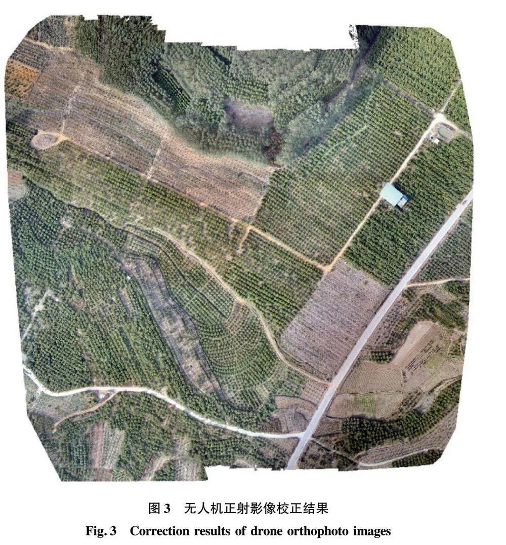
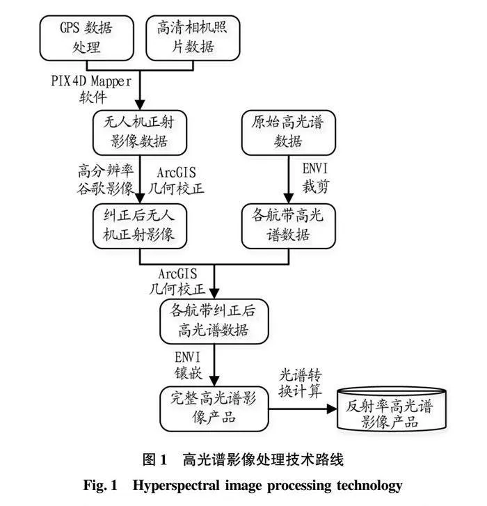


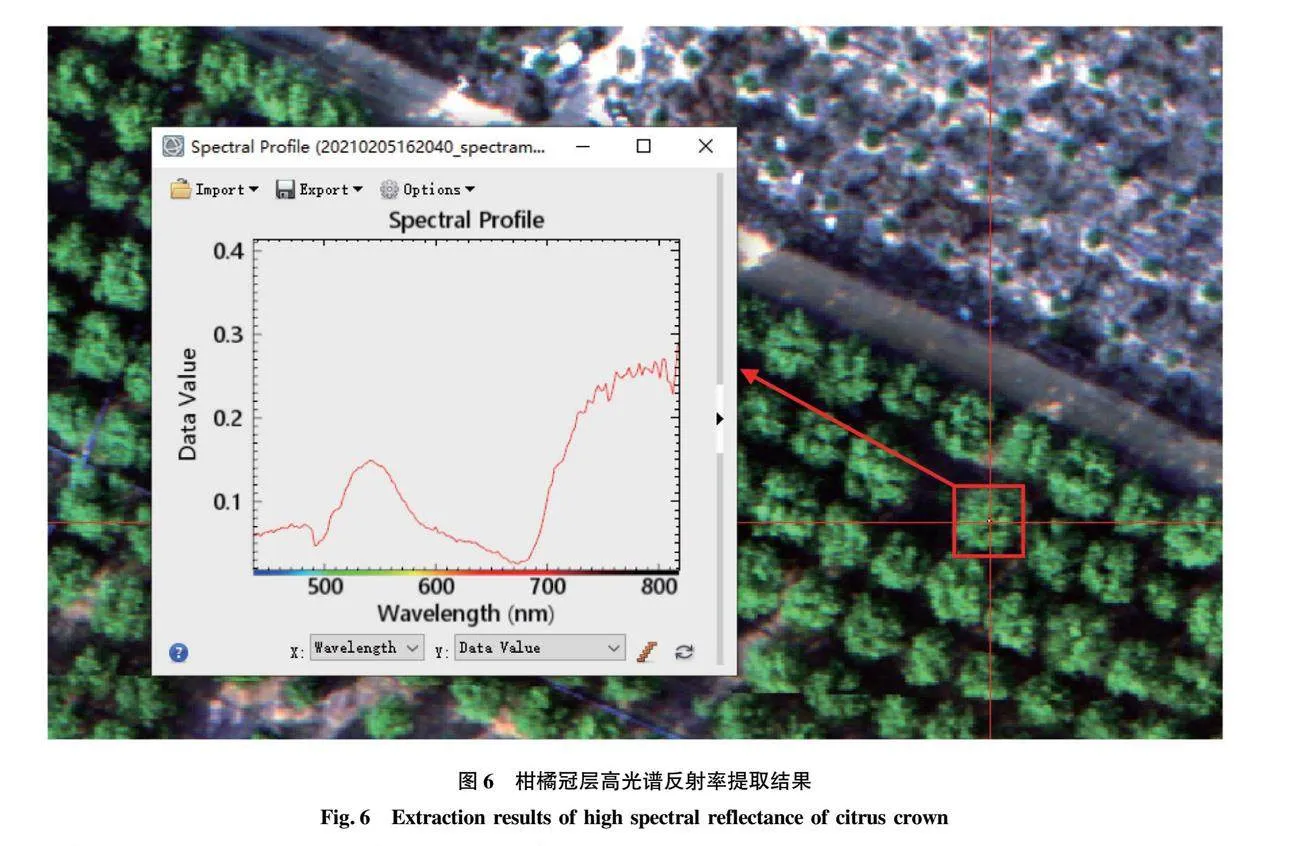
摘要 為解決IspecHyper(萊森光學)多旋翼無人機高光譜成像系統缺乏數據處理配套軟件,采集多航帶高光譜數據誤差大、坐標缺失、無法自動拼接等問題,以武鳴區太平鎮角龍村柑橘種植基地為研究區,開展IspecHyper多旋翼無人機高光譜影像處理方法研究。首先,利用IspecHyper-VM200成像系統獲取研究區高清照片和多航帶高光譜影像數據;其次,以高清照片為數據源,通過PXI4D Mapper軟件預處理和ENVI軟件影像幾何校正,形成高分辨率無人機正射影像;最后,利用ENVI軟件裁剪多航帶高光譜影像扭曲邊界數據,以無人機正射影像為基準完成幾何校正,進而通過影像鑲嵌和光譜轉換計算,形成高光譜反射率影像產品。結果表明,該研究形成的技術方法可有效解決IspecHyper多旋翼無人機高光譜影像處理存在問題,同時為無人機高光譜影像處理提供技術參考。
關鍵詞 遙感;IspecHyper;無人機;高光譜影像;圖像處理
中圖分類號 P231 文獻標識碼 A 文章編號 0517-6611(2024)17-0233-05
doi:10.3969/j.issn.0517-6611.2024.17.053
Research on Hyperspectral Image Processing Method of IspecHyper Multi-rotor UAV
MA Can-da, SU Qiu-qun, XIE Guo-xue et al
(Agricultural Science and Technology Information Research Institute, Guangxi Academy of Agricultural Sciences, Nanning, Guangxi 530007)
Abstract In order to solve the problems of IspecHyper multi-rotor UAV hyperspectral imaging system, such as lack of data processing supporting software, large error in collecting multi-band hyperspectral data, lack of coordinates, and inability to automatically stitch. Taking the citrus planting base of Jiaolong Village, Taiping Town, Wuming District as the research area, this paper studies the hyperspectral image processing method of IspecHyper multi-rotor UAV. Firstly, the IspecHyper-VM200 imaging system was used to obtain high-definition photos and multi-band hyperspectral image data of the study area. Secondly, using high-definition photos as data sources, high-resolution UAV orthophotos were formed by PXI4D Mapper software preprocessing and ENVI software image geometric correction. Finally, the ENVI software was used to cut the distorted boundary data of multi-band hyperspectral images, and the geometric correction was completed based on the UAV orthophoto image, and then the hyperspectral reflectance image product was formed through image mosaic and spectral conversion calculation. The experimental results show that the technical method formed in this paper can effectively solve the problems of hyperspectral image processing of IspecHyper multi-rotor UAV, and provide technical reference for hyperspectral image processing of UAV.
Key words Remote sensing;IspecHyper;Unmanned aerial vehicle;Hyperspectral;Image processing
基金項目 國家自然科學基金項目(42061071);廣西科技重大專項(桂科AA22036002);廣西創新驅動發展專項(桂科AA18118046);廣西農業科學院科技發展基金資助項目(桂農科2022JM47,桂農科2024YP065,桂農科2021ZX03)。
作者簡介 馬燦達(1992—),男,廣西南寧人,工程師,從事農業遙感技術應用研究。通信作者,工程師,碩士,從事農業遙感技術應用研究。
收稿日期 2023-09-27
隨著遙感對地觀測技術的不斷發展,無人機遙感影像的采集與處理能力日漸強大,無人機能夠較好降低氣候條件的影響,克服空間分辨率不足,提高工作效率等性能,使其成為支撐中小區域遙感監測不可或缺的重要手段。……
登錄APP查看全文