武漢市南湖2000—2021年水域面積時空變化分析
2024-09-20 00:00:00殷宗敏楊玉龍孫晨柳思羽劉學浩何文熹
安徽農業(yè)科學
2024年17期
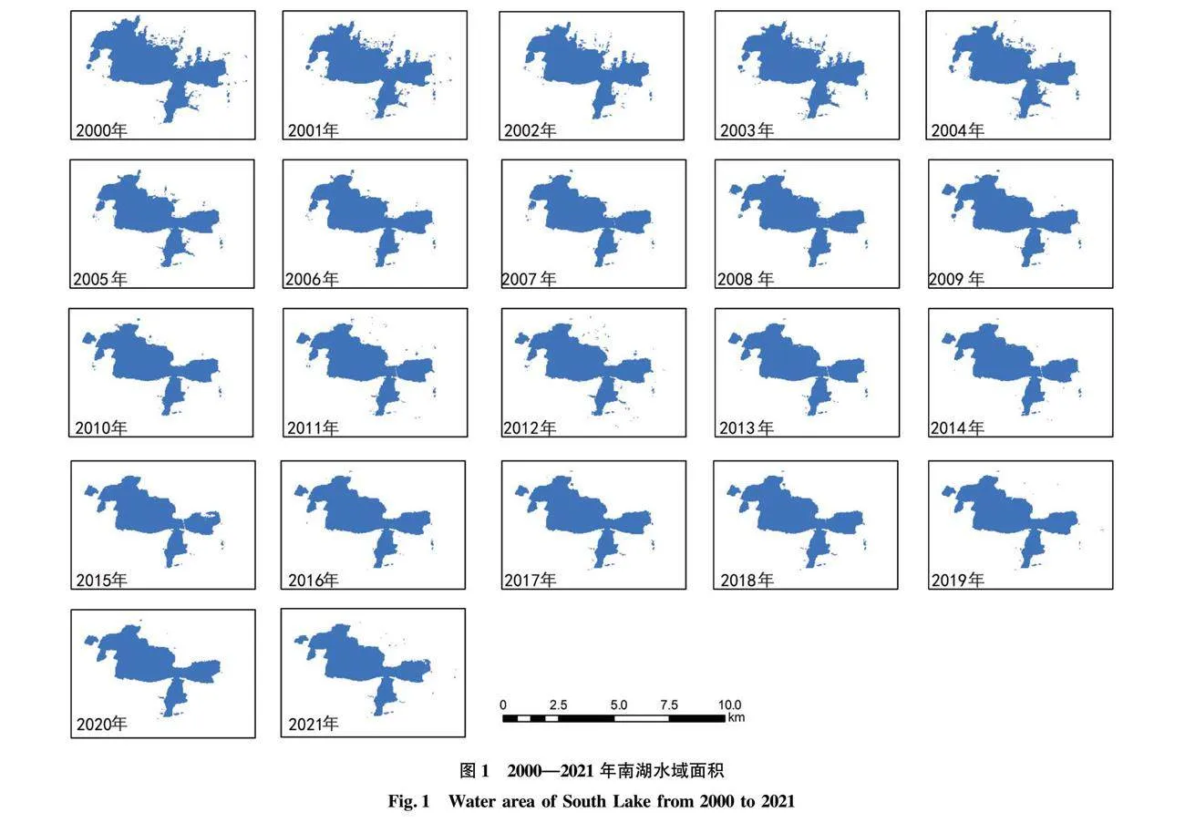
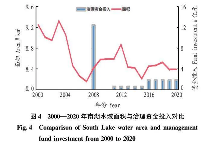
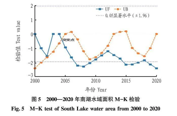
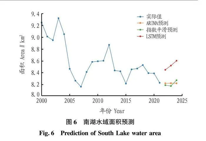
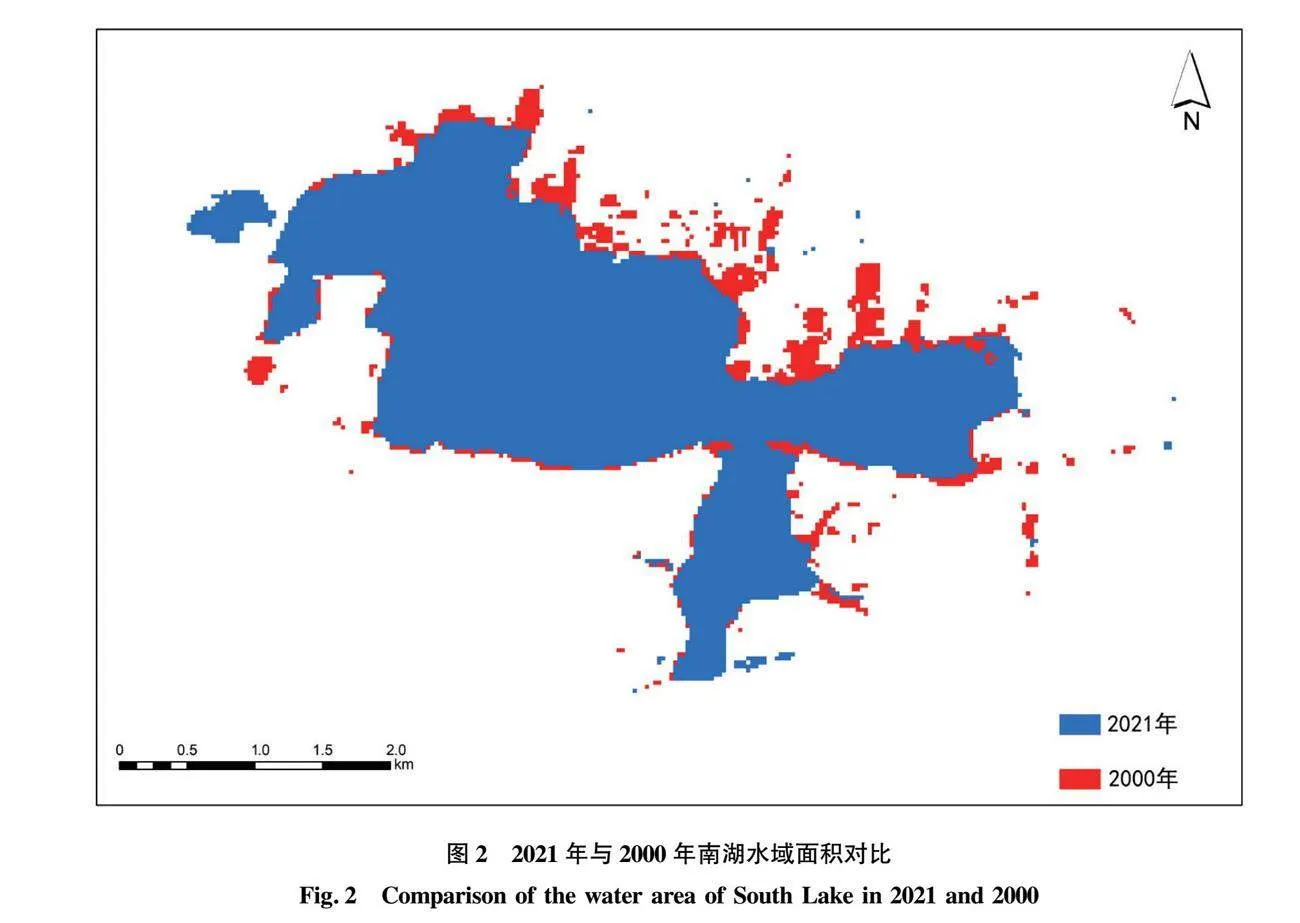
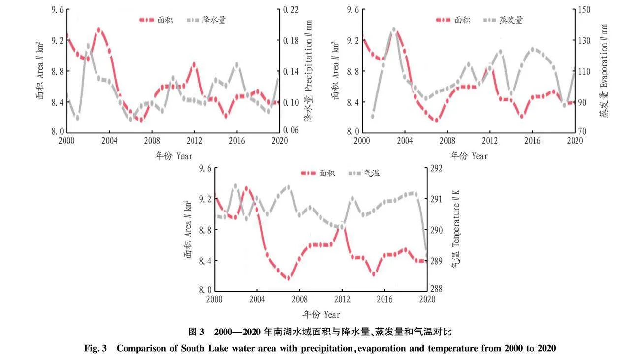
摘要 基于Landsat衛(wèi)星數(shù)據(jù),采用波段比值法獲取2000—2021年武漢市南湖水域面積,分析南湖水域面積時空變化。結果表明:南湖2003年水域面積最大,水域面積在2000—2007年呈現(xiàn)縮小,2008—2012年呈現(xiàn)增大,2013—2021年又呈現(xiàn)縮小,南湖治理時間與水域面積增大時間點重合,說明湖泊治理取得了成效。南湖2000—2021年水域面積整體呈現(xiàn)縮小,面積縮小總量為1.02 km2,且北面、東面的面積縮小變化最為明顯,南湖水域面積在2004—2005年呈現(xiàn)突變性快速縮小。南湖水域面積與蒸發(fā)量存在正相關,南湖水域面積與氣溫存在負相關。指數(shù)平滑模型和神經網(wǎng)絡模型(LSTM)都能預測南湖水域面積,且水域面積在2022—2024年呈現(xiàn)增大,但指數(shù)平滑模型預測結果更準確。
關鍵詞 Landsat衛(wèi)星數(shù)據(jù);水域面積;時空變化;相關性;武漢市南湖
中圖分類號 K928.43 文獻標識碼 A 文章編號 0517-6611(2024)17-0072-04
doi:10.3969/j.issn.0517-6611.2024.17.015
Analysis of Spatiotemporal Changes in Water Area of South Lake from 2000 to 2021 in Wuhan City
YIN Zong-min,YANG Yu-long,SUN Chen et al
(Wuhan Geological Survey Center of China Geological Survey,Wuhan,Hubei 430205)
Abstract Based on Landsat satellite data,the band ratio method was used to obtain the water area of South Lake in Wuhan City from 2000 to 2021,and the spatiotemporal changes of the water area of South Lake were analyzed.The results showed that in 2003,South Lake had its largest water area,with a decrease in water area during 2000-2007,an increase during 2008-2012,and another decrease during 2013-2021.The timing of South Lake’s management coincides with the period of increased water area,indicating the effectiveness of lake management.Overall,the water area of South Lake decreased from 2000 to 2021,with a total reduction of 1.02 km2.The most significant reductions occurred on the northern and eastern sides,and there was a rapid and abrupt decrease in South Lake’s area during 2004-2005.South Lake’s water area changes exhibit a positive correlation with evaporation,and a negative correlation with temperature.Both the exponential smoothing model and the long short-term memory (LSTM) neural network model could predict South Lake’s surface area.The water area was projected to increase from 2022 to 2024.However,the predictions from the exponential smoothing model were more accurate.
Key words Landsat satellite data;Water area;Spatiotemporal change;Correlation;South Lake in Wuhan City
基金項目 國家自然科學基金項目(42107485)。
作者簡介 殷宗敏(1992—),男,江西廬山人,工程師,碩士,從事地質遙感、GIS數(shù)據(jù)分析方面的研究。通信作者,高級工程師,碩士,從事自然資源督察技術方面的研究。
收稿日期 2023-10-09
武漢市南湖作為武漢市第三大城中湖,其面積變化與周邊生態(tài)環(huán)境密切相關,南湖面積縮小和消失會影響武漢地區(qū)的水資源供應和生態(tài)系統(tǒng)平衡,因此研究南湖面積變化趨勢對環(huán)境保護和地區(qū)生態(tài)可持續(xù)性具有重要的意義。同時治理南湖污染,一直是人們關注的焦點問題。
湖泊面積的提取有多種方法:①基于紋理特征的方法,利用紋理特征來提取水體,湖泊水體的紋理特征和周圍陸地不同,通過分析影像中像素的紋理信息,可以將水體從陸地分離出來;……
登錄APP查看全文