基于KinectV2.0的視覺SLAM建圖研究與誤差分析
2021-09-23 00:50:01馬佳豪,郭中華
電腦知識與技術(shù) 2021年21期
關(guān)鍵詞:移動機器人
馬佳豪, 郭中華
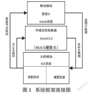


摘要:目前,基于RGB-D攝像頭的視覺SLAM是該領(lǐng)域的研究熱點之一。傳統(tǒng)視覺SLAM因精度較差的問題,應(yīng)用范圍遠不如激光SLAM,文中以此構(gòu)建了基于KinectV2.0的視覺SLAM系統(tǒng)來驗證此問題;算法方面,Gmapping算法在RBPF粒子濾波算法基礎(chǔ)上優(yōu)化了提議分布并且選擇性重采樣從而減少了計算量,因此選用Gmapping算法在三個不同復(fù)雜程度的場景下進行地圖構(gòu)建實驗,最后對三個場景下的建圖數(shù)據(jù)和實測數(shù)據(jù)進行誤差分析。實驗結(jié)果表明,基于KinectV2.0構(gòu)建的視覺SLAM系統(tǒng)在三個場景下的建圖精度和穩(wěn)定性與激光SLAM相比擬,因此在光照變化較小或不變的場景下可選用視覺SLAM以降低成本,一定程度上可以減少設(shè)備成本并降低技術(shù)難度。
關(guān)鍵詞:視覺 SLAM;移動機器人;RGB-D;回環(huán)檢測;建圖精度
中圖分類號:TP242? ? ? ?文獻標(biāo)識碼:A
文章編號:1009-3044(2021)21-0001-03
開放科學(xué)(資源服務(wù))標(biāo)識碼(OSID):
Study and Error Analysis of Visual SLAM Mapping Based on KinectV2.0
MA Jia-hao1, GUO Zhong-hua1,2
(1.School of Physics and Electronic-Electrical Engineering, Yinchuan 750021, China; 2. Ningxia Key Laboratory of Intelligent Sensing for Desert Information, Yinchuan 750021, China)
Abstract:Currently, visual SLAM based on RGB-D camera is one of the research hotspots in this field. Due to the problem of poor accuracy of traditional visual SLAM, the application range is far inferior to laser SLAM. In this paper, a visual SLAM system based on KinectV2.0 is constructed to verify this problem; in terms of algorithm, the Gmapping algorithm optimizes the proposal based on the RBPF particle filter algorithm The distribution and selective resampling reduces the amount of calculation. Therefore, the Gmapping algorithm is selected to conduct map construction experiments in three scenes of different complexity. Finally, the error analysis of the mapping data and the measured data in the three scenes is carried out. The experimental results show that the mapping accuracy and stability of the visual SLAM system based on KinectV2.0 in the three scenes is comparable to that of laser SLAM, so visual SLAM can be used in scenes with small or constant illumination changes to reduce costs , To a certain extent, it can reduce equipment costs and reduce technical difficulties.
Key words: visual SLAM; mobile robot; RGB-D; loop detection; mapping accuracy
1 引言
同時定位及地圖構(gòu)建(SLAM, simultaneous localization and mapping)出現(xiàn)于機器人應(yīng)用領(lǐng)域 , SLAM技術(shù)[1]目標(biāo)是使機器人在一個未知環(huán)境中使其實時重新構(gòu)建當(dāng)前未知環(huán)境的地圖結(jié)構(gòu),同時對自身進行定位。移動機器人的同步定位和地圖構(gòu)建(SLAM)技術(shù)成了移動機器人發(fā)展進程中亟待解決的一個核心問題,在實現(xiàn)SLAM技術(shù)的基礎(chǔ)之上,才能使移動機器人真正地實現(xiàn)自動化,才能使機器人在更多領(lǐng)域煥發(fā)出應(yīng)有的活力。SLAM技術(shù)的實現(xiàn)大致分為兩個主要方向——激光SLAM技術(shù)和視覺SLAM(V-SLAM)技術(shù),一般來說激光SLAM精確度較高,但是成本高,采集數(shù)據(jù)量大,對計算力要求嚴(yán)苛,只利用相機作為傳感器的SLAM被稱為視覺SLAM[3],作為當(dāng)前SLAM框架的主要類型,激光SLAM與視覺SLAM必將在相互競爭和融合中發(fā)展。
文獻[4]構(gòu)建了一個基于手持 Kinect 的 RGB-D SLAM 系統(tǒng),文獻[5]中首次提出了基于Kinect的SLAM系統(tǒng),文獻[6]中提到視覺SLAM的傳感器有單目、雙目、RGB-D攝像頭。文獻[7]中在RBPF SLAM基礎(chǔ)上對提議分布和重采樣進行了優(yōu)化,其算法被實現(xiàn)為開源的SLAM功能包Gmapping。為了保證建圖與定位的準(zhǔn)確性,實驗設(shè)備使用RGB-D攝像頭作為數(shù)據(jù)采集設(shè)備,在光照強度一定的前提下,利用基于粒子濾波算法優(yōu)化的Gmapping功能包對于三種不同復(fù)雜程度的環(huán)境進行地圖構(gòu)建,并與環(huán)境實測數(shù)據(jù)對比進行誤差分析,最終通過本實驗的建圖結(jié)果驗證與分析,在誤差允許范圍內(nèi)視覺SLAM在環(huán)境光正常、構(gòu)建小場景地圖時可以保證建圖精確度,因此基于KinectV2.0的視覺SLAM在建圖精度和穩(wěn)定性方面可以與激光SLAM的精度與穩(wěn)定性相比擬。
猜你喜歡
北京航空航天大學(xué)學(xué)報(2022年6期)2022-07-02 01:59:12
四川輕化工大學(xué)學(xué)報(自然科學(xué)版)(2021年3期)2021-08-30 06:37:02
中國慣性技術(shù)學(xué)報(2019年3期)2019-10-15 07:21:02
電子測試(2018年15期)2018-09-26 06:01:34
制造技術(shù)與機床(2017年3期)2017-06-23 08:11:21
智能系統(tǒng)學(xué)報(2015年4期)2015-12-27 09:38:35
機電產(chǎn)品開發(fā)與創(chuàng)新(2014年5期)2014-03-11 16:42:32
鄭州大學(xué)學(xué)報(理學(xué)版)(2014年3期)2014-03-01 04:21:09
中國海洋大學(xué)學(xué)報(自然科學(xué)版)(2014年8期)2014-02-28 12:21:31
中國海洋大學(xué)學(xué)報(自然科學(xué)版)(2014年7期)2014-02-28 12:21:19