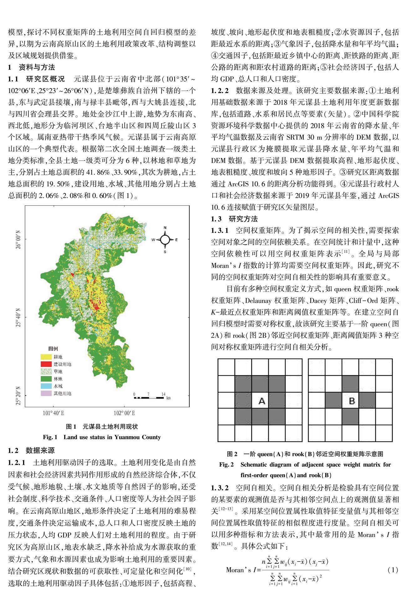
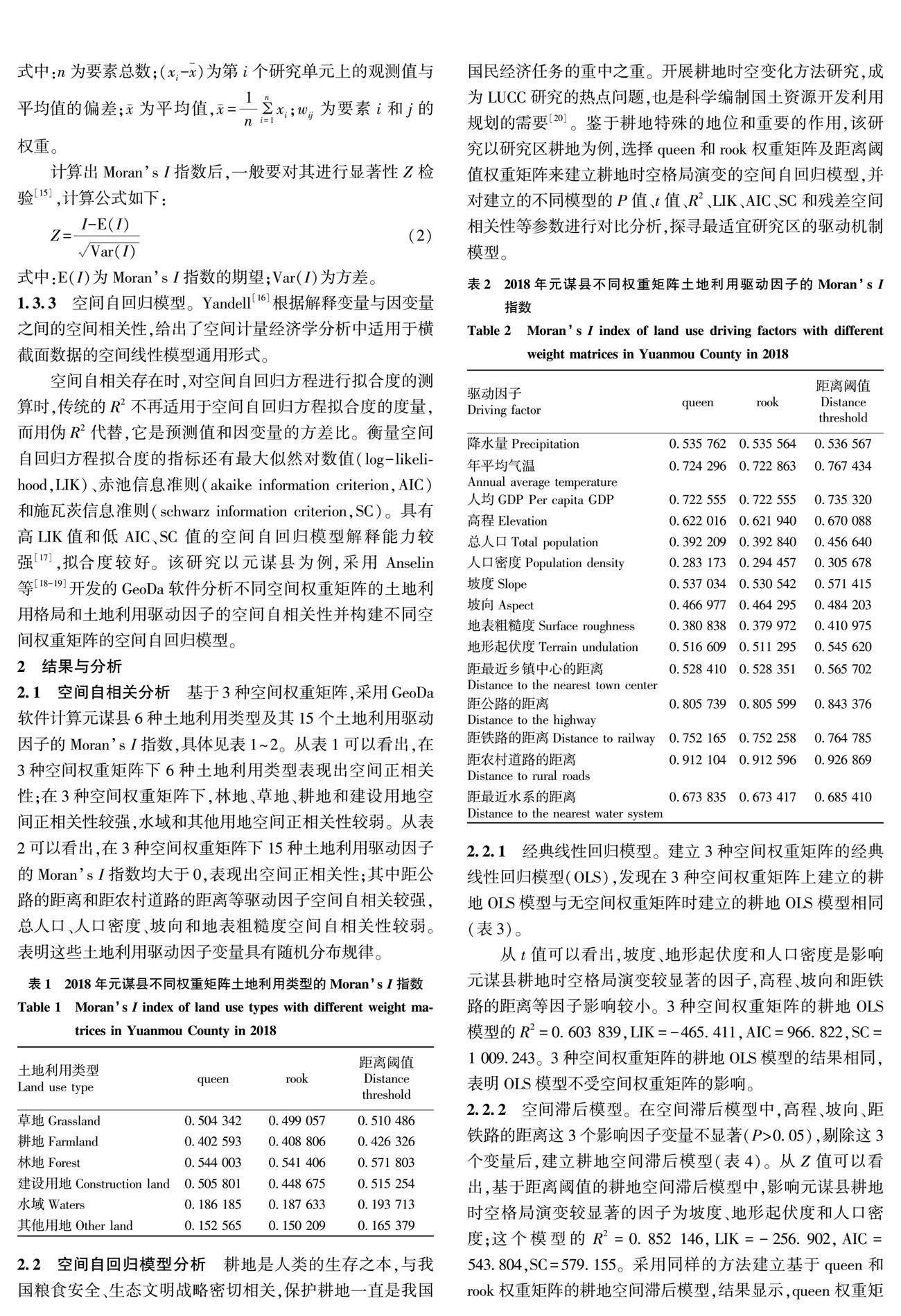
基于不同權(quán)重的土地利用空間自相關(guān)模型對(duì)比分析
2024-06-23 10:36:57胡銳劉志偉張雄浩徐志鴻趙俊三
安徽農(nóng)業(yè)科學(xué)
2024年11期
胡銳 劉志偉 張雄浩 徐志鴻 趙俊三
摘要 [目的]研究不同空間權(quán)重矩陣對(duì)土地利用空間自相關(guān)模型的影響。[方法]以元謀縣土地利用變量為基礎(chǔ),首先分析不同權(quán)重矩陣下土地利用類型及其驅(qū)動(dòng)因子的空間自相關(guān)性,建立基于queen權(quán)重矩陣、rook權(quán)重矩陣和距離閾值權(quán)重矩陣的耕地時(shí)空格局演變的空間自回歸模型,選取擬合優(yōu)度、最大似然對(duì)數(shù)值、赤池信息準(zhǔn)則、施瓦茨信息準(zhǔn)則、影響因子數(shù)量和模型殘差空間自相關(guān)性等參數(shù)作為模型評(píng)價(jià)指標(biāo),對(duì)比分析經(jīng)典線性回歸模型、空間滯后模型和空間誤差模型的差異。[結(jié)果]2018年元謀縣土地利用類型和土地利用驅(qū)動(dòng)因子在不同空間權(quán)重矩陣下均呈現(xiàn)出較強(qiáng)的空間正相關(guān)關(guān)系。通過對(duì)比3種權(quán)重矩陣的經(jīng)典線性回歸模型、空間滯后模型和空間誤差模型,發(fā)現(xiàn)在同一空間自相關(guān)模型中,基于距離閾值權(quán)重矩陣的空間自回歸模型的擬合效果較好,基于同一個(gè)空間權(quán)重矩陣,空間誤差模型的擬合效果較好。[結(jié)論]空間相關(guān)性與空間權(quán)重矩陣有關(guān),基于距離閾值矩陣的空間誤差模型的擬合度最高,解釋能力最強(qiáng),能更好表征云南高原山區(qū)的土地利用格局的空間演變。
關(guān)鍵詞 土地利用;空間權(quán)重矩陣;空間自相關(guān);空間自回歸模型;元謀縣
中圖分類號(hào) F301.2? 文獻(xiàn)標(biāo)識(shí)碼 A? 文章編號(hào) 0517-6611(2024)11-0054-06
doi:10.3969/j.issn.0517-6611.2024.11.012
Comparative Analysis of Spatial Autocorrelation Models of Land Use Based on Different Weights—A Case Study of Yuanmou County
HU Rui1,2, LIU Zhi-wei1, ZHANG Xiong-hao3 et al
(1.Southwest Survey and Planning Institute of National Forestry and Grassland Administration, Kunming, Yunnan 650031;2.Faculty of Land Resource Engineering, Kunming University of Science and Technology, Kunming, Yunnan 650093;3.Surveying and Mapping Engineering Institute of Yunnan Province, Kunming, Yunnan 650033)
Abstract [Objective]To study the impact of different spatial weight matrices on the spatial correlation model of land use. [Method]Based on the land-use variables of the administrative village of Yuanmou County, this paper first analyzed the spatial autocorrelation of land-use types and their driving factors under different weight matrices, and established an algorithm based on the queen weight matrix, rook weight matrix and distance threshold weight matrix. Spatial autoregressive model for the evolution of the spatio-temporal pattern of cultivated land. Parameters such as goodness of fit, maximum likelihood logarithm, Akaike information criterion, Schwartz information criterion, number of influence factors and spatial autocorrelation of model residuals were selected as model evaluation indicators.The differences between the classic linear regression model, the spatial lag model and the spatial error model were compared and analyzed. [Result]In 2018, land use types and land use drivers in Yuanmou County showed a strong positive spatial correlation under different spatial weight matrices. By comparing the classic linear regression model, spatial lag model and spatial error model of the three weight matrices, it was found that in the same spatial autocorrelation model, the fitting effect of the spatial autoregressive model based on the distance threshold weight matrix was better; based on the same space,the weight matrix and the spatial error model fit better. [Conclusion]The spatial correlation was related to the spatial weight matrix. The spatial error model based on the distance threshold matrix had the best fitting degree and the strongest interpretation ability, which could better represent the spatial evolution of the land use pattern in the mountainous plateau of Yunnan.
Key words Land use;Spatial weight matrix;Spatial autocorrelation;Spatial autoregression model;Yuanmou County
基金項(xiàng)目 國家自然科學(xué)基金項(xiàng)目(41761081)。
作者簡介 胡銳(1995—),男,云南文山人,工程師,碩士,從事地理信息系統(tǒng)及自然保護(hù)地規(guī)劃研究。……
登錄APP查看全文
 安徽農(nóng)業(yè)科學(xué)
2024年11期
安徽農(nóng)業(yè)科學(xué)
2024年11期
- 安徽農(nóng)業(yè)科學(xué)的其它文章
- 基于文獻(xiàn)計(jì)量的稻田生態(tài)種養(yǎng)研究進(jìn)展及趨勢分析
- 特色蔬菜蘆筍產(chǎn)業(yè)發(fā)展現(xiàn)狀與趨勢研究
- 農(nóng)民工職業(yè)發(fā)展研究的演變路徑與發(fā)展趨勢研究
- 基于灰色關(guān)聯(lián)度模型的紅棗產(chǎn)業(yè)提質(zhì)增效路徑探索
- 數(shù)字鄉(xiāng)村建設(shè)對(duì)農(nóng)村居民消費(fèi)影響的異質(zhì)性及特征
- 數(shù)字金融發(fā)展對(duì)農(nóng)民可持續(xù)性增收的影響機(jī)制