財稅史里話運河
2020-12-08 02:07:56陳陽
文化交流 2020年11期
關鍵詞:杭州
陳陽
運河從來不是哪個帝王一時心血來潮下江南的產物,它是王朝統治的經濟命脈,國家財政運轉賴以為系的動脈,也是國家財政支出的對象,是古代中國財政運轉最具體的媒介之一。
半個中國之財賦悉由此路而進
中國地勢西高東低,大型的天然河流(例如海河、黃河、淮河、長江、錢塘江等)一路向東,流入大海。為了解決南北之間的交通運輸問題,古代中國人只能通過開鑿南北走向的人工水系來連通天然的大江大河,因而成就了中國貢獻給世界的歷史遺產、南北走向的大型人工水系——京杭大運河。
京杭大運河開鑿于春秋,擴修于隋,繁榮于唐宋,取直于元,疏通于明清,是中華文明的重要標識。大運河早期多因戰爭需要而開鑿,隋唐以后直至明清的主要功用是漕運,是持續至今仍在使用的活態文化遺產。
京杭大運河流經北京、天津、河北、山東、河南、安徽、江蘇、浙江六省二市,其演變與發展涉及制度、經濟、社會、文化等諸多方面。作為由國家開鑿、政府管理的巨大水利工程體系,大運河承載了以農立國的古代中國特有的漕運文化傳統。
浙江境內的古運道
京杭大運河浙江段作為中國大運河的南端,包括形成時間較早、連續運用時間最長、自然條件最好的河段——江南運河和大運河內河航運通道與外海連接的紐帶——浙東運河兩段河道,至今仍發揮著航運、水利、行洪等功能。它們的歷史,是一部越地從區域性政權融入統一帝國、越地文化和中原文化交流融合的歷史,也是一部國家為了汲取稅賦推動運河貫通、帶動城市發展的歷史。
我國河流多為東西走向,戰國以前,水路運輸仍限于自然河道范圍內,南北交通極為不便。春秋末年,各國開始興建運河工程溝通天然水道,但這些工程普遍規模較小。南方吳、越兩國分別崛起后,隨著經濟、軍事的發展開始向外擴張,原來的天然河流已經不能滿足航運需求,由此,兩國先后利用東南地區水網發達的優勢,開始改造、建設一些運河,用于航運、灌溉之用。
吳國開鑿了一條連通吳地到長江的南北向運河,與江北的邗溝串聯,形成吳地向北的運河水系;向南修建百尺瀆,連通吳越兩地,從由拳(嘉興)出發,經過鹽官到達錢塘江,渡江以后進入越地,最終連通越國都城會稽。這是文獻記載可見的太湖流域與浙江(錢塘江)最早的聯系通道。這條水運通道存在數百年,是吳越兩地主要的聯系渠道,一直到秦始皇征服楚國后,在長江南翼開辟陵水道,渡江不再經由鹽官,而是多經由更加安全的錢塘縣(杭州)。陵水道逐漸取代百尺瀆,成為溝通太湖流域與浙江(錢塘江)的主要聯系通道。這條渠道的開筑,使偏遠的越國地區、會稽郡范圍的地域有效地進入了中央政府控制的范圍內,也形成了今日所說江南運河浙江段的早期形態。
越王勾踐時期貫通的山陰故水道,西起紹興城東郭門,東至今上虞縣東關鎮練塘村,全長約20.7公里,與《越絕書》的記載大致符合。東晉時會稽內史賀循連接、疏浚了山陰故水道和其他舊有河道的一部分,形成西陵運河。后又不斷改造,這條由錢塘江而達會稽的運河,與上虞以東運河以及姚江、甬江的自然水道一起最后匯入東海,形成了通江達海的浙東運河。
這些人工開鑿的運河,在不同地域的具體河段可能有特定的名字,不同時期的拓展延伸或改建又會形成新的名字,今天的人需要一些時間才能理清它們的關系。
錢塘江兩岸的運河,和其他區域的人工運河一起,到戰國末期已經形成了一張四通八達的水路交通網,也拉開先秦各國水利建設的序幕,不僅溝通幾大水系,暢通了區域交通網絡,改善了沿岸農業條件,促進了工商業的興盛,加強了各地區思想文化的交流,也加速了各民族間的溝通、交往與融合,為進入統一大帝國的時代奠定了物質基礎。
一條關系國家安定的通道
隨著秦漢帝國的建立,人工運河的主要功能從軍事、政治轉向漕運。
漕運是封建王朝通過水路(或附以陸路)向都城或其他指定地點大規模輸送糧草的一種經濟活動。這種國家財政物資的撥付轉運,一般有三大類別:供都城消費的“京師之運”,供軍隊之需的“兵營之運”,供賑災濟荒的“賑濟之運”。其中以保證皇室、百官及中央行政運轉所需的“京師之運”最為根本。因漕運而生的一整套制度、設施以及活動于其間的人,隨著漕糧主要產地的轉移和經濟重心區的變化,共同構成古代封建王朝的動力供應系統。
漕糧從哪里來,決定了漕運網絡的形狀和布局。中國古代漕糧來源地的變化,使漕運體系的發展呈現出明顯的階段性特點。
秦漢時期,漕糧供應地主要是黃河中下游地區,關東、山東粟運往關中政治中心所在,這個階段漕運以長安為中心,稱為“關東之漕”。東漢至隋唐,隨著江南的開發,東南地區日漸成為朝廷的主要賦稅來源,漕糧供應地由關東逐漸轉向江淮,“關東之漕”轉為“江淮之漕”。
把漕糧供應地更緊密地聯系起來,是隋朝建國以后修建貫通南北的大運河的巨大推動力。隨著大運河北通涿郡,南達錢塘江,它終于可以被稱為京杭大運河了,其中,長江以南的這一段,北起鎮江,南至杭州,又稱江南運河,河面開闊,舟楫往來最為便利,成為中原地區通往江南的主要運輸通道。
唐代安史之亂以后,東南地區較少經受戰亂破壞,長江下游經濟得到迅速發展,全國的經濟中心逐步從黃河流域轉向長江流域,朝廷用度隨之開始仰仗東南一帶。史書上說,“賦出于天下,江南居十九”,“天下大計,仰于東南”,中央政府的糧食和衣料主要依賴東南漕運。兩浙的漕糧由運河轉輸,漕運阻滯時,唐政府的官員和軍隊的衣食都成問題。
北宋以后,經濟重心完全南移,江南地區成為經濟與賦稅重心。貫穿南北的京杭大運河,把江南經濟重心與北方政治中心聯接在一起,改變了延續千年之久的以中原地區為中心的漕運體系,原來的“江淮之漕”轉變為“江南之漕”。
北宋都城汴京(又稱大梁、今開封),南宋都城臨安(今杭州),分處運河南北的水陸交通中心和漕運樞紐位置,以汴京或臨安為中心建立起來的漕運體系,形成一個嚴密而有效的供給系統,源源不斷地將各地糧食物資輸送到都城所在地,也將中國古代漕運發展推向巔峰時期。
運河南端的杭州城
從東西向的“關東之漕”到南北向的“江南之漕”,財政經濟大動脈的根本轉向就發生在兩宋。這種轉向甚至帶動了政治軸心的改變,我們對首都的稱呼,從東都、西都變成了南京、北京。
位于京杭大運河最南端的杭州,也在這個過程中改變了命運。春秋至隋以前的兩浙一帶,錢塘江以北(即浙西)以吳郡(即蘇州)為重鎮,錢塘江以南(即浙東)以會稽為中心。杭州所在的錢唐,不過區區一縣,地位大不如吳郡、會稽。
隋文帝時期楊素主持營建杭州城,是杭州歷史上第一次建造州城。緊接著江南運河疏浚貫通,杭州成為貫穿中國南北大運河的南端終點,由此開始了從原來的山中小縣,逐步成為水居江河之會、陸介兩浙之間的要地,走向了大都市的發展歷程。
南宋建都臨安(即杭州),運河是溝通中原的主要渠道,從鎮江至杭州這一段的運河有專門名字——浙西運河。
到了元朝,大運河疏浚取直,不再繞道洛陽,以最短的距離,縱貫當時最富庶的東部沿海區域,實現了國家政治中心和經濟中心的大融合。
南宋以后,杭州雖然喪失了政治中心的優勢,但唐宋以來的發展打下了良好的基礎。到了明朝,杭州商業繁榮,街道上商店林立,貨物充盈,一派繁榮景象。
從宋代到明清,由杭州府之武林驛,向北經過湖州府德清縣,嘉興府崇德縣、桐鄉縣,最后到達蘇州府吳江縣,始終是經由杭州城北上的主要通道。
北宋熙寧年間日本僧人成尋,坐船從杭州出發北上汴梁,其《參天臺五臺山記》記錄了行船路線及所用時日,走的就是這條線路。
南宋時陸游《入蜀記》記錄了他從紹興出發到蜀地的經由線路,在錢塘江以南,經過柯橋、錢清、蕭山、西興,走的正是浙東運河。渡江以后,走浙西運河,線路與成尋所記載的相同。
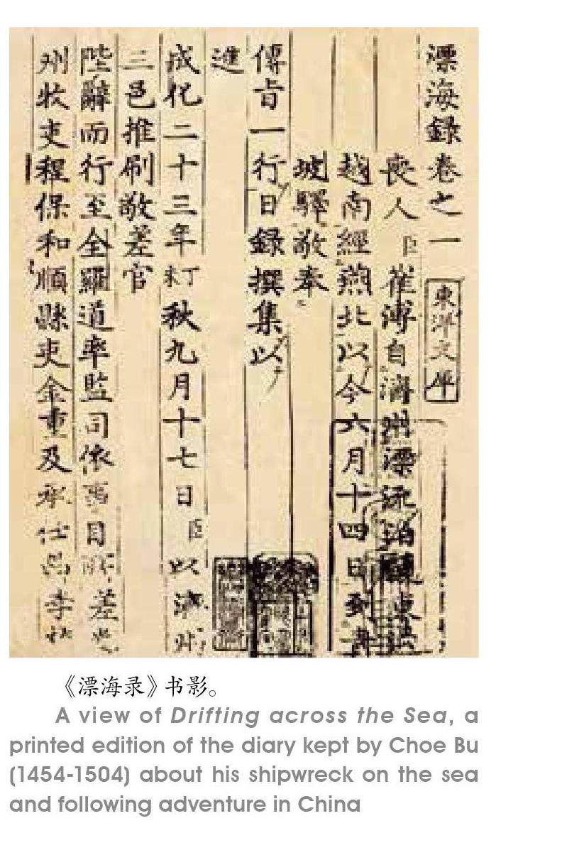
明代弘治年間,朝鮮文臣崔溥從濟州出發前往羅州,途中不幸遭遇海難,在海上漂流13天后,意外地漂到了中國。在浙江臺州府臨海牛頭外洋(今屬浙江三門縣)登陸后,經寧波、紹興至杭州,繼而沿運河路北上,抵達北京,再經陸路返回朝鮮,歷時135天,成為明代第一個行經運河全程的朝鮮人。崔溥回國后,將這段神奇的經歷撰寫成書,名為《漂海錄》。
到了清代,對這條線路的記錄更是比比皆是。
杭州城北的大關和運河稅收
歷代商民的經濟交往、文化交流沿著大運河展開,但它首先是一條輸送國家財政稅收物資的“高速路”,上面航行的最重要的是漕船。裝載著稅收征繳的白銀、銅錢、糧食作物和紡織品,源源不斷地通過運河進入國家倉庫。
我們通常把北宋傳世名畫《清明上河圖》作為風俗畫解讀,其實畫家還著重描繪了漕運綱船,選取的題材和內容都是頗有深意的。
《清明上河圖》留下了宋代漕船的清晰形象,畫中畫了大大小小共29只船,分為漕船、客船和游船三類,畫中圓短體闊的平底船,吃水淺,窗戶少,載重量大,由官營作坊制造,在汴河上主要擔負運輸任務。透過畫面,畫家想告訴觀畫人,漕運是一件關乎京師供給的國之大事。
運河沿岸還有用于中轉的糧倉。今天這些糧倉的遺址也成為運河文化遺產的重要組成部分。興建于清代光緒年間的富義倉,建成后一直是杭州百姓最主要的糧食供應地,江南谷米的集散地,上繳朝廷的稅糧也從這里啟程北運。
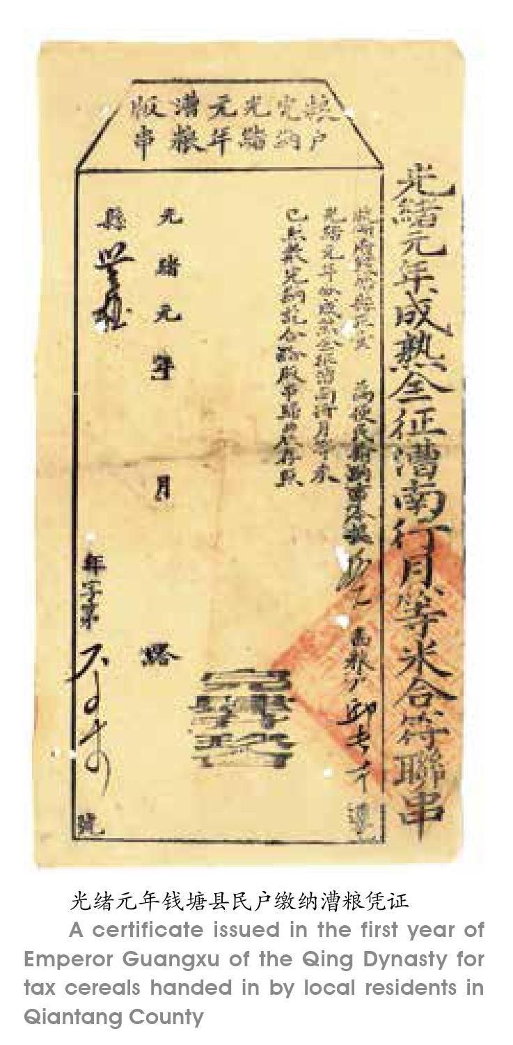
國家也在大運河上面設置常關,征收國內關稅。明清時期杭州城北所設北新關就是運河上重要的稅關。
北新關在明代一直由南京戶部差官管理。清初,由戶部差官管理。康煕五十五年,停差戶部官,由巡撫監收。雍正七年,稅務交由織造府管理。清代的北新關在實際的管理運作中,由大關及其七務、六關、十門、八口址總共三十二所組成,由大關統率,各司其職,形成嚴密的商稅控制網絡。如果按照乾隆十八年的統計數據,北新關的稅收收入近22萬兩,占清代在大運河、長江、淮河等重要水域交通要道所設稅關總收入的百分之五強。
北新關是明清時代杭州的標志性景觀,它在杭州城北前后存在400多年時間,至今在杭州人的觀念和語言習慣中,仍保留著“大關”這一詞匯。
大運河開鑿貫通后在漕糧輸運中發揮著重要作用,是國家財政運轉賴以存在的重要基礎設施,但是它的疏浚和維護也需要大量的財政支出。大運河支流繁多,與黃河、淮河、長江之間水道交匯錯綜復雜,這些水系的自然變遷都可能對大運河造成巨大影響,因此,對大運河的疏浚治理是歷代政府的常態之舉。例如,防止黃河泥沙流入運河,就一直是保證運河通航必須解決的老大難問題,為此修建了一系列的堤、壩、閘、墩、引河、河口等復雜的水工系統。在浙江境內,運河過錢塘江時也留下了若干重要的水利工程設施。浙東運河穿過多條自然河流,為維持水位的穩定并灌溉兩岸農田,沿線設置了大量由堰壩和閘門組成的水利設施。
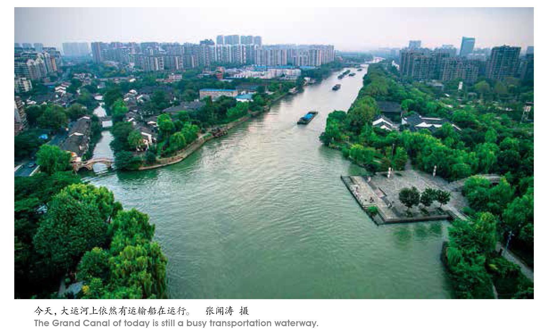
唐宋以來,上萬只漕船,在不同季節時令運載著數百萬石漕糧,在喧囂靜謐交替中往返于產糧區與京師之間。商品與貿易,方言與文化,信仰和文學,摻雜著社會風俗,與往來的漕船一起,隨著運河水的流動,直到今天,依然在我們的生活里泛起點點漣漪。
Grand Canal: Imperial Lifeline
By Chen Yang
The Beijing-Hangzhou Grand Canal dates back to the Spring & Autumn period. It extended and expanded in the Sui Dynasty (581-618) and became full-flung in the centuries of the Tang (618-907) and the Song (960-1279). In the Yuan Dynasty (1279-1368), the major watercourse was straightened. In the Ming (1368-1644) and the Qing (1644-1911), it was dredged. It is a landmark canal of Chinese civilization.
The Grand Canal was first dug for war purposes. From the Sui Dynasty on, it functioned as the major route for cereals shipping from production regions in the south to the north and central China. Today, the Beijing-Hangzhou Grand Canal traverses Beijing, Tianjin, Hebei, Shandong, Henan, Anhui, Jiangsu and Zhejiang. The canal has evolved and developed, shaping aspects of Chinas governance, economy, society and culture. As a giant water-control engineering system constructed and operated by the central government, the Grand Canal used to feature the shipping tradition of an agricultural nation.
Ancient canals in Zhejiang
Hangzhou in Zhejiang was at the southernmost tip of the Grand Canal before the system crossed the Qiantang River and extended eastward to Shaoxing and Ningbo. The Jiangnan section of the Grand Canal and the Eastern Zhejiang Canal are very much alive today. They play a key role in cargo shipping, water control and flood discharging. The history of these two canals tells stories concerning how a regional power merged into the empire and how the Yue culture united with the culture of the central kingdom. The history of the two canals also tells how, in order to levy taxes effectively and sustain national revenue, a nation maintained the operation of the canal and boosted the growth and prosperity of canal cities and towns.
River transport in ancient China went from east to west and vice versa largely because rivers in China mainly go from west to east due to the geographic features. It was much difficult to ship cargo through rivers from north to south and vice versa. In Jiangnan or the region in the south of the Yangtze River Delta, there was a dense network of rivers. Boats and ships were the major way to travel around and move things around. In Spring & Autumn centuries, the Wu and the Yue states rose in the region. Canals were constructed for economic and agricultural purposes. The Wu state in the north of Jiangnan built a canal to connect with the Yangtze River. It then built a canal to connect with the Yue state to the south. According to history, the canals and rivers linked the Wu and the Yue, with Taihu Lake at the northern tip of the canal system and Kuaiji, the capital of the Yue, at the southern end of the regional canal system. The canal system shared by the two states prospered for hundreds of years. After the First Emperor of the Qin (221-207BC)unified the whole nation, he had another canal built to make the existing canal system more effective. This correction of the system brought the remote Yue in the south of the Qiantang River under the effective control of the empire.
The canal system to the south of the Qiantang River connects with a number of regional rivers and reaches East China Sea. With the canals and rivers to the north of the Qiantang River, they formed a system. The system boosted social and economic growth of the region and gave support to the empire.
After the Qin Dynasty, the function of the canals shifted from military to cereal transport from the south to the north. In the past, the canal system in China shipped food northward for three important functions: the canal system maintained the food supply and daily consumption of the capital city, shipped food supplies to military, and transported food to regions in emergencies such as natural disasters. The most important task the canal system did was to serve as a lifeline, specifically, for the imperial house, all the officials, and the central government situated in the capital city. To satisfy this requirement, the central government designed and put into place a whole system of administration, policies and rules for the operation of the Grand Canal.
During the Qin and the Western Han (206BC-25AD), the cereal supply came largely from the middle and lower reaches of the Yellow River. During these centuries, Changan in present-day Shaanxi Province in northwestern China was the center and destination of the shipping system and food moved from west to east in the northern part of the country. From the Eastern Han (25-220) down to the Sui and the Tang dynasties, the Southeast China became a major food supplier. The Sui Dynasty extended the canal all the way to the Qiantang River. The canal from south to north of this period can be correctly called the Capital-Hangzhou Canal.
After the An Lushan-Shi Siming Rebellion (755-763) of the Tang Dynasty, the economic center further shifted to the southeast, namely, the region of the lower reaches of the Yangtze River Delta. The tax revenue from the region accounted for the 90% of the national total. The food and fabric supplies from this region kept the central government in operation. In the Northern Song Dynasty, the political center in the north and the economic center in the south were connected and sustained by the canal system.
Hangzhou at the Southern End of the Grand Canal
Hangzhou evolved slowly at the southern end of the Grand Canal. In the Sui Dynasty, the city of Hangzhou was built to guard the southern end of the Grand Canal. The small county nestled at the foot of mountains west of the West Lake moved its capital to the present-day Hangzhou. The new county capital was on the right track onto becoming a metropolis.
The turning point in the history of Hangzhou occurred in the Northern Song and the Southern Song. Hangzhou was the central city of the supply side on the south connecting with the political center in the north during the Northern Song. During the Southern Song, the capital city was the political, cultural and economic center of the dynasty.
In the Yuan Dynasty, the canal didnt go to Luoyang any more. It went straightforward northward to the capital of Yuan Dynasty in the north. The capital was the predecessor of present-day Beijing. The canal became the shortest route that went through the richest regions of the country, fusing the political and economic centers. After the Southern Song Dynasty fell apart, Hangzhou ceased to be the political center of the nation, but it continued to prosper. It prospered more in the Ming and the Qing economically and culturally, as testified by a large amount of travel literature on boat trips from Hangzhou to the north including some well-known accounts by Japanese monks, poets and a Korean government official.
猜你喜歡
科學大眾(2023年17期)2023-10-26 07:38:38
幼兒畫刊(2022年11期)2022-11-16 07:22:36
玻璃纖維(2022年1期)2022-03-11 05:36:12
中國交通信息化(2021年4期)2021-07-21 09:23:34
杭州(2020年6期)2020-05-03 14:00:51
中國音樂教育(2017年2期)2017-05-20 10:20:28
傳媒評論(2017年12期)2017-03-01 07:04:58
汽車與安全(2016年5期)2016-12-01 05:21:55
中國衛生(2016年8期)2016-11-12 13:27:12
看天下(2016年24期)2016-09-10 20:44:10
