中美遙感教材對比分析與思考
2020-02-02 03:55:01李爽李星華沈煥鋒
高教學刊 2020年3期
關鍵詞:教材
李爽 李星華 沈煥鋒

摘? 要:大學教材是傳授學科知識的重要媒介,既需要突出學科的基礎知識,又需要反映出相關領域前沿知識,此外還需要對教學規律有清晰的認識。遙感作為對地觀測的綜合性技術,廣泛應用于各個領域。為了適應社會發展的需求,近年來許多高校相繼設立了遙感科學與技術專業。文章從更新周期、組成形式、體系結構、圖表形式等方面比較了中美兩國有代表性的六本遙感教材,美國教材特點主要表現在教材持續更新,擴展性信息多以及可視化程度高。而國內教材則注重學科知識的系統介紹。這些差異性的分析可為我國遙感教材建設和教學提供有益的啟示。
關鍵詞:中美大學;遙感;教材;比較分析
中圖分類號:G640? ? ? ? 文獻標志碼:A? ? ? ? ?文章編號:2096-000X(2020)03-0016-03
Abstract: University textbooks are important media for imparting subject knowledge. They not only need to highlight the basic knowledge of the subject, but also need to reflect the frontier knowledge in relevant fields. In addition, they also need to have a clear understanding of the teaching rules. As a comprehensive technology of earth observation, remote sensing is widely used in various fields. In order to meet the requirements of social development, many universities have established remote sensing science and technology specialty in recent years. This paper compares six representative remote sensing textbooks between China and the United States in terms of renewal cycle, composition form, system structure and chart form. The characteristics of American textbooks are mainly reflected in the continuous updating of textbooks, extensive information and high degree of visualization. Domestic textbooks focus on systematic introduction of subject knowledge. The analysis of these differences can provide useful enlightenment for the compiling and using of remote sensing textbooks in China.
Keywords: Chinese and American Universities; remote sensing; textbook; contrastive analysis
引言
大學課程教材是向學生傳授知識、訓練能力的主要文字載體。其質量與課程教學效果和課程目標的實現息息相關[1]。大學教材既需要突出學科的基礎知識,又需要反映出相關領域前沿的科學知識,此外還需要對教學規律有清晰的認識。因而優秀的大學課程教材既是學術的積淀也是學科認知過程的總結。它既不同于一般的學術專著,也不同于中小學課程教材固定教學內容的編排。因此,對大學教材進行科學地梳理分析,對于改進大學教學過程與教學質量具有非常重要的作用[2]。
無論是遙感技術的發展還是對遙感教育問題的細致分析,美國在相關領域一直走在國際前列。因此本文從中美遙感教材中各選出了三本典型的教材,試圖從教材更新周期、組成形式、體系結構、圖表形式等多個方面對中美教材在內容上的量化比較,分析國內遙感教材的優勢與不足,以便為將來國內遙感教學及教材的編著提供一些有益的參考。
一、典型中美遙感教材簡介及版本更新情況
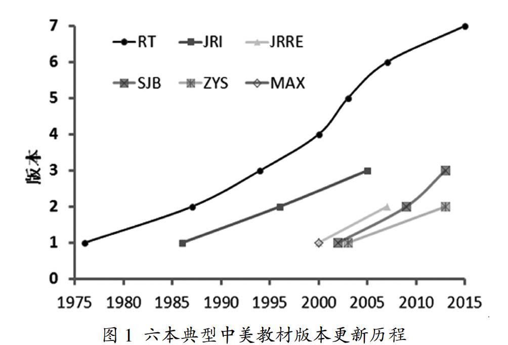
伴隨遙感技術的發展,中美都出版了大量基礎性的遙感教材[3-4]。綜合考慮教材的時效性和代表性,國內的教材從科學出版社、高等教育出版社和武漢大學出版社中各選擇2000年以后出版的遙感教材,具體分別為趙英時等編著的《遙感應用分析原理與方法(第二版)》(以下縮寫為ZYS)[5]、梅安新等編著的《遙感導論》(以下縮寫為MAX)[6],以及孫家抦等編著的《遙感原理與應用(第三版)》(以下縮寫為SJB)[7]。這三本教材也是目前國內高校與科研院所教學中使用較多的幾本教材之一。與之對應,三本美國教材則選擇的Thomas Lillesand等編著的《Remote Sensing and Image Interpretation(seven edition)》(以下縮寫為RT)[8],John R. Jensen編著的《Remote Sensing of the Environment: An Earth Resource Perspective(2nd Edition)》(以下縮寫為JRRE)[9],《Introductory Digital Image Processing: A Remote Sensing Perspective(3rd Edition)》(以下縮寫為JRI)[10]。這三本美國教材都是原有教材的更新版本,其中RT已更新6次,而JRI和JRRE分別更新了1-2次。相比較而言,國內教材3本中有2本有更新版本,其中MAX出版后至今尚未出版更新版本。六本教材具體的更新出版時間如圖1所示。
猜你喜歡
新世紀智能(英語備考)(2021年10期)2022-01-18 05:12:14
新世紀智能(英語備考)(2021年9期)2021-12-06 05:22:38
新世紀智能(英語備考)(2021年11期)2021-03-08 01:10:02
新世紀智能(英語備考)(2020年11期)2021-01-04 00:41:50
新世紀智能(英語備考)(2020年10期)2021-01-04 00:39:10
新世紀智能(英語備考)(2020年6期)2020-08-14 01:06:24
新世紀智能(英語備考)(2020年3期)2020-08-11 09:25:14
新世紀智能(英語備考)(2020年12期)2020-04-13 00:50:42
國際漢語學報(2016年1期)2017-01-20 08:21:07
福建中學數學(2016年7期)2016-12-03 07:10:28