面向組件式GIS技術(shù)的寧波市軌道交通與常規(guī)公交接駁數(shù)字化管理系統(tǒng)設(shè)計與實現(xiàn)
2019-12-19 02:07:13石小偉宋寧劉文
軟件
2019年11期
石小偉 宋寧 劉文
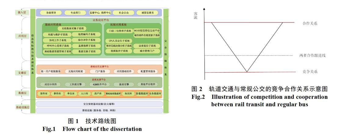

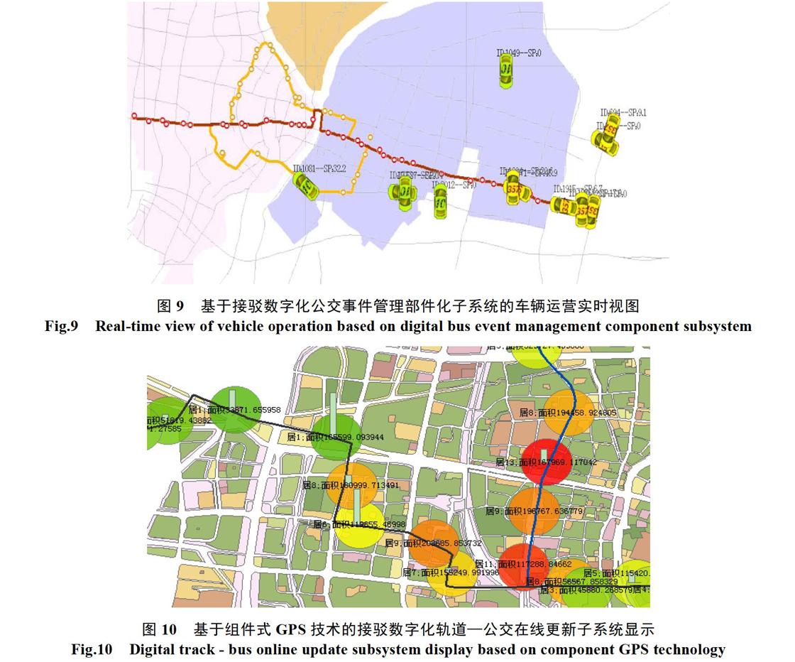
摘? 要: 采用計算機(jī)組件式GIS技術(shù)、空間分析技術(shù)以及軌道交通與常規(guī)公交線網(wǎng)分析評價模型等科學(xué)方法,融合區(qū)域人口、土地利用現(xiàn)狀與公交設(shè)施、軌道交談線網(wǎng)數(shù)據(jù)、公交線網(wǎng)運營數(shù)據(jù)、站點IC刷卡數(shù)據(jù)和公交GPS數(shù)據(jù)等海量信息,建設(shè)寧波市軌道交通與常規(guī)公交接駁數(shù)字化管理系統(tǒng)。該系統(tǒng)能夠?qū)豢土骱凸痪€路進(jìn)行分析評估,并能實現(xiàn)對公交車輛的實時動態(tài)管理與應(yīng)急響應(yīng)。實驗證明:該系統(tǒng)可檢測公交有效乘客量,軌道交通有效乘客量、評測乘客擁擠度狀況并預(yù)警,如前方站點客流預(yù)警、擁擠路段預(yù)警以及公交的運營滿載預(yù)警等從而為寧波市軌道交通與常規(guī)公交的接駁一體化發(fā)展提供有力的輔助決策。
關(guān)鍵詞: 組件式GIS技術(shù);接駁數(shù)字化;軌道交通;常規(guī)公交;信息系統(tǒng)
【Abstract】: Use of GIS, spatial analysis technology of computer components and rail transportation and conventional theory-oriented and scientific methods of analysis and evaluation model, the integration of regional population, land use status and talk to public transport, rail line network data, theory-oriented and operating data, site and bus IC card data GPS data, such as huge amounts of information, the construction of ningbo city rail transit and conventional public transport interchange digital management system. The system can analyze and evaluate bus passenger flow and bus routes, and realize real-time dynamic management and emergency response of bus vehicles. Experiments show: the system can detect the bus passenger volume effectively, rail transit passenger volume, effective evaluation situation and warning passengers crowded degree, such as the front site operation of early warning, crowded roads and public transportation passenger load such as early warning for ningbo joint integration of rail transit and conventional public traffic development provide powerful auxiliary decision-making.
【Key words】: Component GIS technology; Connection digitization; Rail transit; Regular bus; The information system
0? 引言
根據(jù)最新的《寧波市城市軌道交通線網(wǎng)規(guī)劃(修編)》目前形成草案[1]。依照2020年的寧波城市軌道交通建設(shè)方案,寧波市軌道交通線網(wǎng)規(guī)劃由7條線路組成[2],總長約164 km,設(shè)站113座軌道交通進(jìn)出口站點,其中包括11座線路換乘站[3]。目前,常規(guī)公交和城市軌道交通是寧波市交通運營組織的兩大重要組成部分[4]。其中,軌道交通的布局建設(shè)具有固定性,因此,常規(guī)公交線網(wǎng)是城市交通資源靈活布局方案設(shè)計的核心內(nèi)容[5]。
國外的研究軌道交通與常規(guī)公交接駁數(shù)字化管理系統(tǒng)主要側(cè)重在常規(guī)公交、軌道交通線路規(guī)劃、設(shè)計的應(yīng)用,美國波特蘭市是較早采用GIS技術(shù)進(jìn)行軌道交通線網(wǎng)規(guī)劃管理的城市。……
登錄APP查看全文