土地利用景觀生態格局變化及驅動力研究
2019-12-14 14:10:45趙芳張永福歐陽雪
安徽農業科學
2019年19期
趙芳 張永福 歐陽雪

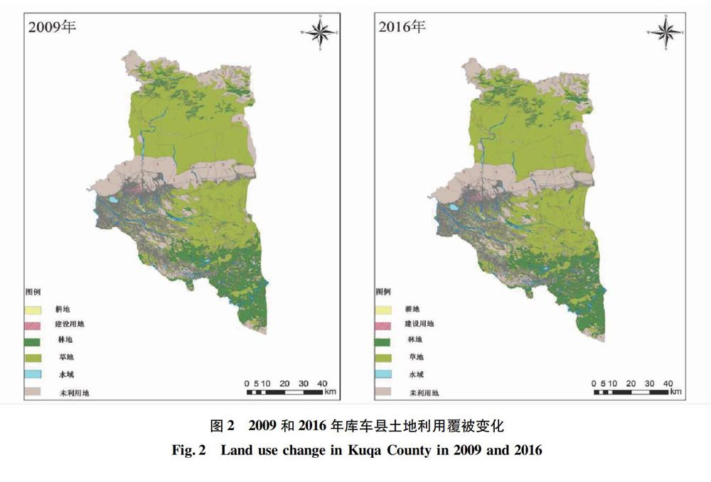

摘要 以庫車縣2009和2016年的高分辨率遙感影像解譯的土地利用變更數據為數據源,運用ArcGIS 10.2、ENVI 5.1和Fragstats 4軟件,通過土地利用動態度指數、景觀指數分析了庫車縣2009—2016年土地利用覆被類型變化特征,并選取政策、人口和社會經濟指標綜合分析引起土地利用覆被類型變化的驅動因子。結果表明:庫車縣土地利用覆被類型整體呈穩定變化狀態,生態環境呈現優良狀態;國家和地區政策因素、人口的迅速增長和經濟實力大幅提升,都對庫車縣的土地利用格局變化有一定的影響。由此可見,對某一地區階段的土地利用格局變化特征及引起變化的驅動力進行分析有重要的理論與實際意義。
關鍵詞 土地利用/覆被;景觀格局;驅動力;庫車縣
中圖分類號 F301.2文獻標識碼 A
文章編號 0517-6611(2019)19-0103-04doi:10.3969/j.issn.0517-6611.2019.19.030
Abstract ArcGIS 10.2, ENVI 5.1 and Fragstats 4 were used as software support, and the land use change data interpreted from high resolution remote sensing images in Kuqa County in 2009 and 2016 were used as data sources. The land use change characteristics of Kuqa County in 2009-2016 were analyzed with land use dynamic index and landscape index, and the comprehensive analysis of policy, population and socioeconomic indicators was selected. The driving factors causing the change of land use and cover types. The results showed that: the overall land use and cover types in Kuqa County are in a stable state, and the ecological environment is in a good state; the policy factors of the state and region, the rapid growth of population and the substantial increase of economic strength all have a certain impact on the change of land use pattern in Kuqa County. Therefore, it is of great theoretical and practical significance to analyze the characteristics of land use pattern change and the driving forces of change in a certain region.
Key words Land use/cover;Landscape pattern;Driving force;Kuqa County
20世紀90年代以來,土地利用/土地覆被的動態變化研究已經逐漸成為全球環境變化領域研究的熱點之一[1]。土地利用變化和城市化對生態系統和可持續土地利用的影響已引起研究人員越來越多的興趣[2]。一系列的活動,如城市發展所需進行的人為活動、各種自然災害、企業只注重自身發展而不考慮對環境造成的損害,將對生態系統的結構和功能產生影響[3-6],進而影響區域的社會經濟發展、生態環境[7-9],如氣候環境的變化[10-11]、生物多樣性、地表徑流與侵蝕[12-14]。因此,研究區域土地利用景觀格局變化及其驅動因子對當地未來的土地規劃和城鎮建設具有一定程度的指導和借鑒作用。……
登錄APP查看全文