結合SLIC和模糊聚類的遙感圖像分割方法
2019-01-02 09:01:18楊麗艷,趙玉娥,黃亮
軟件
2019年12期
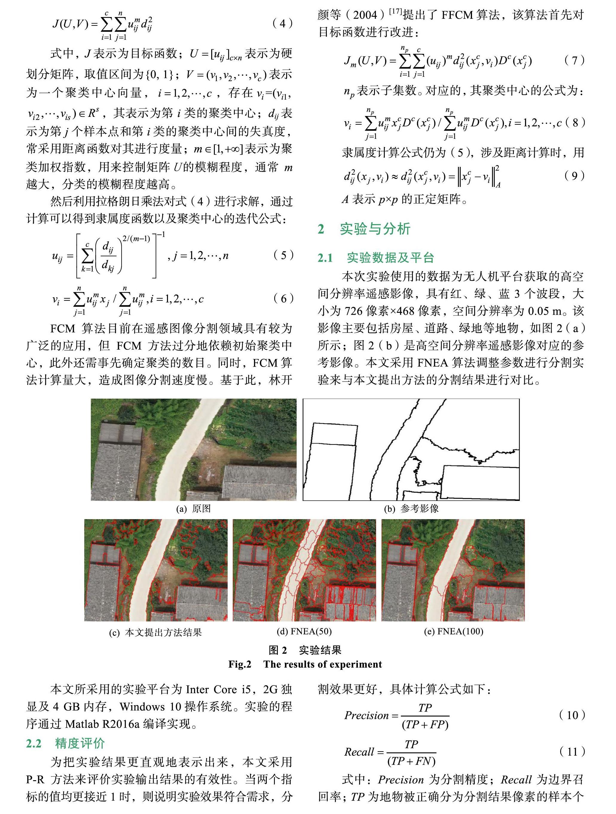
摘 ?要: 超像素分割是目前用于遙感影像分割的研究熱點,但它易產生過度分割的問題。為解決過度分割問題,提出一種簡單線性迭代聚類(SLIC)結合快速FCM聚類算法(Fast fuzzy C-means,FFCM)的遙感圖像分割方法。該方法首先用SLIC算法對初始影像進行預分割;然后使用FFCM對獲取的超像素進行合并。本文將分形網絡演化方法(FNEA)作為對比實驗方法。實驗結果表明,本文提出方法的分割結果與實際地物的相似度更高,抗噪性更好。提出分割方法的精度較FNEA算法相比均有所提高。研究成果可為遙感影像分割提供有效借鑒。
關鍵詞: 遙感圖像;圖像分割;超像素;過分割;分形網絡演化方法
中圖分類號: P237 ? ?文獻標識碼: A ? ?DOI:10.3969/j.issn.1003-6970.2019.12.015
本文著錄格式:楊麗艷,趙玉娥,黃亮. 結合SLIC和模糊聚類的遙感圖像分割方法[J]. 軟件,2019,40(12):6669
Remote Sensing Image Segmentation Method Based on SLIC and Fuzzy Clustering
YANG Li-yan1, ZHAO Yu-e1, HUANG Liang1,2*
(1. Faculty of Land Resource Engineering, Kunming University of Science and Technology, Kunming 650093, China; 2. Surveying and Mapping Geo-Informatics Technology Research Center on Plateau Mountains of Yunnan Higher Education, Kunming 650093, China)
【Abstract】: Superpixel segmentation is currently the research hotspot for remote sensing image segmentation, but it is prone to over-segmentation. In order to solve the problem of over-segmentation, a simple linear iterative clustering (SLIC) combined with fast FCM clustering algorithm (FFCM) is proposed. Firstly, the initial image is pre-segmented by the SLIC algorithm; then the FFCM is used to merge the acquired superpixels. In this paper, the fractal network evolution method (FNEA) is used as a comparative experimental method. The experimental results show that the segmentation results of the proposed method are more like the actual ground features and better anti-noise. The accuracy of the proposed segmentation method is improved compared with the FNEA algorithm. The research results can provide effective reference for remote sensing image segmentation.
【Key words】: Remote sensing; Image segmentation; Superpixels; Over-segmentation; Fractal network evolution method
0 ?引言
圖像分割是指遵照一定的相似性準則把圖像分割成具有特殊語義信息的若干不同子區域。遙感圖像分割是遙感圖像處理中一項非常重要的技術,在遙感圖像處理中扮演著一個重要的角色,同時也是圖像處理中的重點和難點[1-2]。隨著攝影測量和遙感等技術的發展,對遙感圖像的分割成為了一個研究熱點。近年,遙感圖像的分割方法層出不窮,超像素分割作為其中的一種方法,給遙感圖像的分割也帶來了極大的方便。超像素是由一系列空間位置相鄰、光譜、亮度、紋理等特征相似的像元點所構成的圖像子區域。超像素分割可將遙感圖像劃分為具有相似特征的圖像子區域。……
登錄APP查看全文
