不同雨強和坡度下侵蝕性風化花崗巖母質坡地產流產沙特征
2018-09-03 01:37:20鄧龍洲張麗萍范曉娟鄔燕虹孫天宇
農業工程學報 2018年17期
鄧龍洲,張麗萍,范曉娟,鄔燕虹,孫天宇,費 凱
?
不同雨強和坡度下侵蝕性風化花崗巖母質坡地產流產沙特征
鄧龍洲,張麗萍※,范曉娟,鄔燕虹,孫天宇,費 凱
(浙江大學環境與資源學院,浙江省農業資源與環境重點實驗室,杭州 310058)
為研究解決南方侵蝕性風化花崗巖地區的水土流失問題,該文采用室內人工模擬降雨方法研究了不同降雨強度(30,60,90,120,150 mm/h)和不同坡度(5°,8°,15°,25°)條件下的風化花崗巖殘積坡地的土壤侵蝕過程。結果表明:1)坡面徑流的初始產流產沙時間都隨著坡度和雨強的增大而提前;2)坡面徑流量與坡度之間不呈簡單的正相關關系,徑流系數隨雨強的變化呈現指數相關關系,入滲率在雨強為30~120 mm/h之間在坡度8°左右出現極大值;3)侵蝕產沙量隨坡度和雨強的增大而增大,其與坡度之間的關系可以用冪函數表示,決定系數均達到0.815,與雨強之間為指數函數關系,決定系數均達到0.889以上;4)水力侵蝕對泥沙具有分選性,徑流侵蝕挾帶泥沙中的粉粒、黏粒以及細砂粒含量較多;5)坡度和雨強對于侵蝕產沙量的綜合影響可以用線性相關方程來比較準確地描述,對產沙量的影響權重排序為:含沙量>雨強>徑流系數>坡度。
土壤;侵蝕;徑流;風化花崗巖;人工模擬降雨;坡度;雨強;產沙
0 引 言
降雨造成的土壤侵蝕是世界范圍內嚴重的環境問題,會導致土壤退化和水環境污染[1]。坡度是影響坡面土壤侵蝕的重要因素之一[2-3],同時也是水土流失方程中的重要因子[4]。大量的研究表明,在一定范圍內,坡度越大時產生坡面徑流和土壤流失量越高[5-6]。也有研究表明,當坡度達到某些值時,坡度和土壤侵蝕量之間的關系出現反轉[7-8]。降雨過程中的土壤侵蝕是由雨滴擊濺和坡面徑流引起的土壤分離和搬運的復雜現象[9]。土壤顆粒隨徑流的遷移是坡面侵蝕的主要表現方式,侵蝕產沙是一個復雜的過程,受降雨強度和下墊面等因素的綜合影響,侵蝕量的變化對于探討降雨過程中的侵蝕產沙規律至關重要[10]。當前國內外研究人員多通過室內模擬降雨或野外徑流小區試驗方法對坡度和土壤侵蝕量之間的關系進行分析[11-14],GIS技術的運用使得對土壤侵蝕坡度范圍的研究取得較大進展[15],但沒有對作用機理進行解釋說明。一些學者從水動力學方向對坡度與坡面侵蝕量的關系進行研究[16-17],也有很多學者進行了坡度與坡面侵蝕模型的研究[18-21]。例如,Martínez-Murillo等[22]認為降雨模擬試驗可廣泛應用于巴德蘭地區的地貌研究,降雨強度、徑流系數和坡角對侵蝕產沙量和泥沙分離有正向影響,降雨模擬增加了對土壤侵蝕過程的時空變化的理解。馮秀等[23]通過室內人工模擬降雨試驗,研究降雨強度、坡度及地表覆蓋3個因素對花崗巖紅壤坡面侵蝕過程的影響,發現地表覆蓋具有良好的侵蝕減沙作用。Magesh等[24]開發了一個自動化的侵蝕模型用于確定印度南部盆地潛在的土壤侵蝕區,分析了研究區土壤侵蝕和泥沙產量的分布,認為低水平的土壤侵蝕能反映該地區子流域的氣候變化和地形。由于試驗條件不同,所導致的坡面侵蝕產流產沙以及臨界坡度等問題尚無一致結論。
目前關于坡度和雨強對坡面侵蝕產沙產流影響方面的研究對象以紅壤和紫色土為主[25-27],尤其針對中國南方多雨且土層較薄的風化花崗巖坡地的侵蝕產沙對坡度和雨強的響應問題,值得進一步的深入探究[28]。降雨是造成中國東南部土壤侵蝕的主導因子,風化花崗巖又是南方土壤侵蝕的重要組成部分。早在20世紀90年代,就有學者對花崗巖侵蝕區的土壤侵蝕與治理進行了研究。阮伏水[29]就坡度和坡長對土壤侵蝕的影響進行了研究,發現土壤侵蝕隨坡度的增加而加劇,兩者之間呈現冪函數關系,但由于坡地類型不同,所建立的經驗模型的坡度冪指數差異較大。隨著坡度的增加,土壤侵蝕的發展方向是面蝕-溝蝕-崩崗蝕-滑坍,即由水蝕逐漸向重力侵蝕過渡。崩崗侵蝕一旦出現,往往成為花崗巖區最劇烈的侵蝕方式,形成災難,一定時間內很難治理、逆轉,將長期影響著水土流失[30]。華中農業大學研究團隊針對鄂東南花崗巖崩崗區發育的表土層、紅土層、砂土層、碎屑層,進行了不同坡度和不同流量相結合的室內放水沖刷試驗,對定量研究崩崗不同土層土壤剝蝕率、預測土壤剝蝕過程及建立崩崗侵蝕物理模型具有重要的理論和實踐意義[31]。同時研究了鄂東南地區崩崗崩壁不同層次的土壤水分特征,以期區分各層次土壤水分與崩崗侵蝕的聯系[32]。徐加盼等[33]通過室內人工模擬降雨,采用三維激光掃描技術研究了花崗巖風化土體侵蝕表面特征。這些成果對于風化花崗巖地區的土壤侵蝕研究與治理工作具有較大的指導意義。
綜上所述,設計不同降雨和不同坡度組合情況下的侵蝕產沙特性的研究具有重要的現實意義。因此,本文采用人工模擬降雨試驗方法,研究不同降雨強度下坡度對侵蝕性風化花崗巖殘積坡地的土壤侵蝕過程的影響,以加深對風化花崗巖母質坡地土壤侵蝕規律的認識,并為建立土壤侵蝕預報模型和水土流失治理提供理論依據。
1 材料與方法
1.1 試驗土壤
試驗土壤采自浙江省安吉縣。安吉縣位于浙江省西北部,天目山北麓,北緯30°23′~30°53′,東經119°14′~119°53′,屬中亞熱帶季風區,雨量充沛,氣候溫和。全縣年平均氣溫15.60 ℃,雨日171 d,年日照時數1 792 h,多年平均相對濕度81%,年平均降雨量1 414 mm,年降雨量最大值1 869.9 mm,最小值850 mm,每年3~5月份降雨量占全年降雨量的20%,6~10月為58%,1~2月及11~12月為15%。研究區屬于典型的南方紅壤丘陵區,土壤類型為發育于風化花崗巖母質上的紅壤,但由于嚴重的土壤侵蝕,地表砂化嚴重,剖面從下向上依次為母質層、碎屑層、砂土層,其侵蝕特征和發育程度在東南丘陵地區具有典型代表性。土壤呈弱酸性,pH值6.22,平均容重為1.55 g/cm3,自然狀態下初始含水量為8%±1.5%,土壤飽和含水量為11%左右,有機質含量2.70 g/kg,粒徑組成為黏粒(<0.002 mm)占8.24%,粉粒(0.002~0.02 mm)占12.25%,砂礫(0.02~2 mm)占79.51%,為典型的砂土。
本研究所選的采樣土壤為砂土層出露的坡地土壤。從土壤發生學分層來看,砂土層下伏層應該是碎屑層,但由于所采集土壤剖面砂土層與碎屑層無明顯分界,其砂土層內部上下土壤結構并不一致。所以,采用等深度采樣方法進行原狀土搬遷,及室內對應層位徑流槽填充。首先在原地從地表每5 cm分層采集裝袋,共采集12層,60 cm厚度的土壤,并分層測試土壤容重。為了最大程度地保證土壤的相似性,在室內徑流槽中對應層位填充,邊填土邊灑水壓實,以使徑流槽內部土壤狀態盡量和野外狀態一致,保證每個層次土壤容重的一致性,并用力將土槽的邊緣壓實,以減小邊際效應。然后擱置一段時間,讓其自然沉實(45 d)使土體恢復自然特征后開始降雨試驗。在每場降雨試驗前采集土樣并測定土壤前期含水量,以確保所有模擬試驗土壤的初始含水率基本相同。
1.2 試驗裝置
試驗于2017年3-8月在浙江大學農業科學試驗站(中國長興)的人工模擬降雨實驗基地進行,人工模擬降雨器采用西安清遠測控技術有限公司研發的QYJY-502型便攜式自動人工模擬降雨系統,主要由降雨噴頭、供水管路、壓力表、回水閥、供水水泵、不銹鋼支架、開關閥等部分組成,雨強由全自動降雨設備“控制器”控制(圖1),雨強連續變化范圍為15~200 mm/h,精度控制在99%,降雨高度為6 m。試驗徑流槽采用自行設計的一種變坡式壤中流三維立體模擬監測徑流試驗槽(ZL201620924448.7),共設計2個并行排列的徑流槽,降雨器同時覆蓋2個徑流槽,予以重復計算。徑流槽的幾何規格長寬高分別為200 cm×100 cm×60 cm,采用液壓裝置來控制徑流槽坡度,坡度在0°~30°范圍內可靈活調節。徑流槽底部的前側和左右兩側設置延伸槽,高度3 cm,內鋪小孔徑的金屬細網,用于方便收集壤中流。徑流槽前部頂端設計有三角形出水口,連接集流槽,用于收集坡面徑流含沙水樣,底端有三角形鐵制集水槽且裝有水龍頭,用于接取壤中流水樣。

圖1 便攜式自動人工模擬降雨系統與“控制器”設備
1.3 試驗設計與泥沙分析
試驗降雨強度是根據當地縣氣象局統計資料而設計的,依據多年平均降雨的分布特征及出現頻率較大的降雨強度與侵蝕性暴雨等級之間的差值等差平分,共設計5個雨強,分別為30,60,90,120,150 mm/h。試驗坡度的控制依據為《中華人民共和國水利行業標準》SL 190-2007坡面面蝕強度分級指標,分別為5°,8°,15°,25°,具體坡度通過安置在徑流槽上的鉛錘裝置讀取。
通過坡度和雨強2個研究變量的組合設置,共進行有效降雨試驗20場次。降雨強度控制采用系統校準與標定相結合的方法,首先用擋雨布遮蓋徑流槽后進行雨強控制系統的核準,然后開始試驗標定,使系統的波動誤差在允許范圍內,達到目標雨強后移走雨布并開始進行計時,記錄坡面徑流和壤中流開始產流的時刻。坡面產流產沙收集總時間為產流開始后的90 min,總降雨歷時為開始有效降雨到坡面徑流收集結束為止。每3 min取1次徑流泥沙樣,每場降雨試驗共采集徑流泥沙樣品30個,測量每個徑流樣品的體積,然后將徑流樣品靜置沉淀36 h后,倒去上清液,放入105 ℃烘箱烘干后測得產沙量與粒徑組成。所有計算結果是2個徑流槽數據的平均值。
2 結果與分析
坡面徑流侵蝕是坡面物質組成與降雨徑流特性的函數,徑流是泥沙的載體,徑流量及徑流系數的大小取決于雨強、坡度及初始產流時刻。
2.1 坡面產流特征
在試驗設計條件下,坡面徑流的初始產流時間(T)具有明顯的規律性(表1),其隨坡度、雨強而變化。由表1可知,坡度相同的條件下,T都隨著雨強的增大而提前,時間從大到小依次為30>60>90>120>150 mm/h。以5°坡度為例,T隨雨強增大依次減小了13.08,7.33,2.17,0.62 min,其他坡度條件下也呈現相同遞變規律,但是減小的程度隨著坡度的增大而逐漸變弱。在降雨強度一致的情況下,T整體隨著坡度的增大而提前,時間從大到小依次為5°>8°>15°>25°,T減小的程度隨著降雨強度的增大而逐漸變弱。馮秀等[23]在福建花崗巖地區的研究結果也表明起始產流時間隨降雨強度和坡度的增加而有所提前。初始產流時間與雨強之間關系密切的原因在于坡面存在不同的產流方式,當降雨強度小時產流方式為蓄滿產流,當降雨強度大時則形成超滲產流;隨著坡度的增大,徑流重力沿坡面方向的水平分力增大,可加快徑流速度,使產流時間提前。
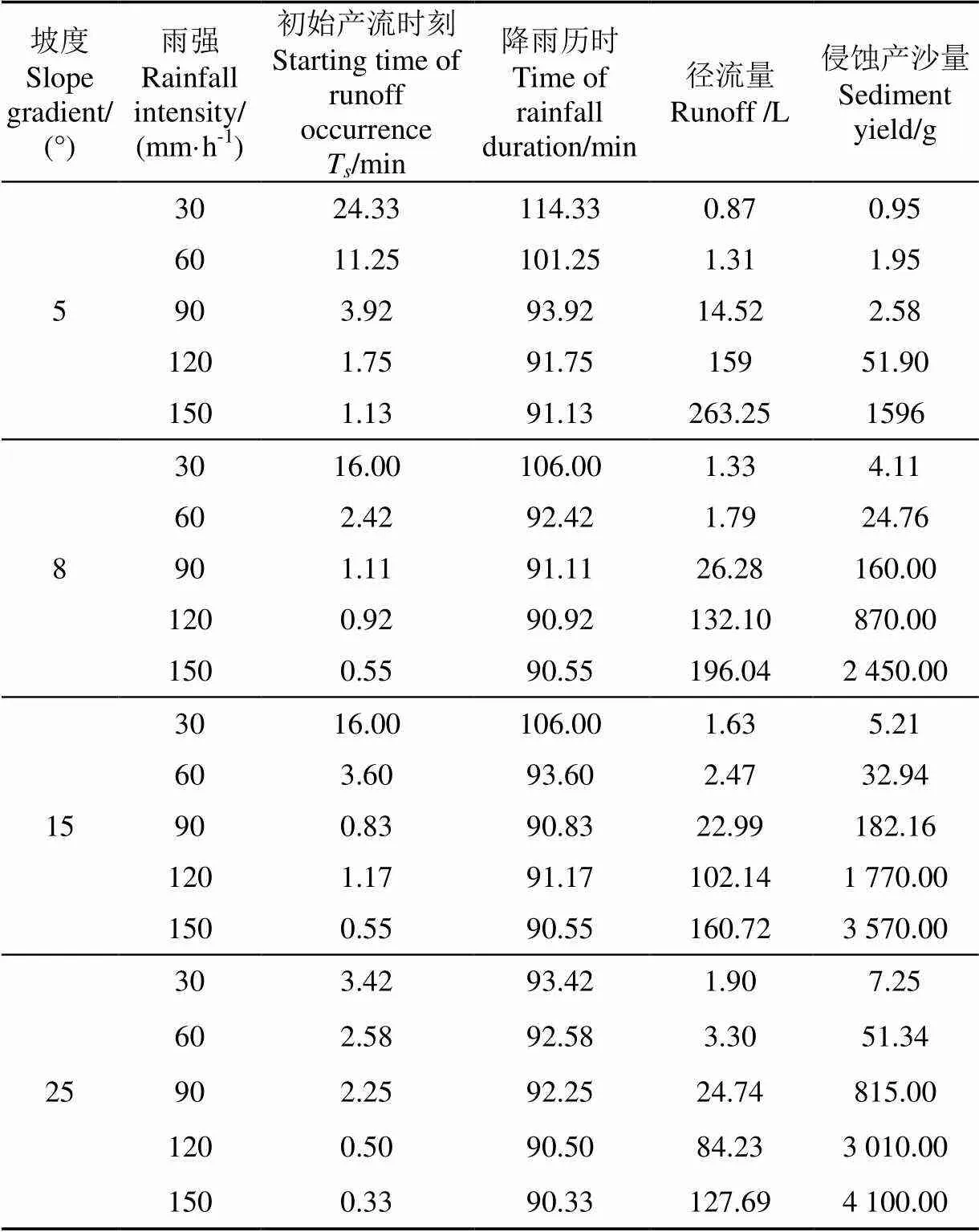
表1 試驗監測數據統計表
就坡度對徑流的影響而言,由表1數據分析可知,坡面徑流量在相同坡度條件下隨著雨強的增大而增大。坡面徑流量與坡度在不同雨強下并不呈現簡單的正相關關系,分大雨強(120、150 mm/h)和中小雨強(30、60、90 mm/h)2種情況而出現不一樣的結果。坡度一定時,中小雨強條件下的坡面徑流量都小于30 L,尤其是30、60 mm/h的坡面徑流量很小,隨坡度的增大而增大。而大雨強150、120 mm/h條件下,坡面徑流量的變化發生了逆轉,在相同雨強時隨著坡度的增大呈現遞減的趨勢。其可能因為大雨強條件下,初始降雨時更容易沖刷攜帶走坡面的小顆粒泥沙,使得地表沙化顆粒增多,易于降雨的下滲,導致最終出口處收集的坡面徑流量減少。
在表1數據的基礎上,計算了徑流系數,并繪制了徑流系數隨雨強和坡度的動態特征曲線(圖2)。由圖2可知,徑流系數隨雨強的變化都呈現為指數相關,其相關系數均大于0.932,并隨雨強的增大,增加的幅度在增大。其中25°坡度條件下的最大,相關性最好。從5個雨強的增加規律來看,當雨強小于90 mm/h時,徑流系數隨坡度的變化不明顯,在雨強大于90 mm/h的情況下,徑流系數增加幅度倍增,而且在4個不同坡度的情況下,5°條件下增加最快。
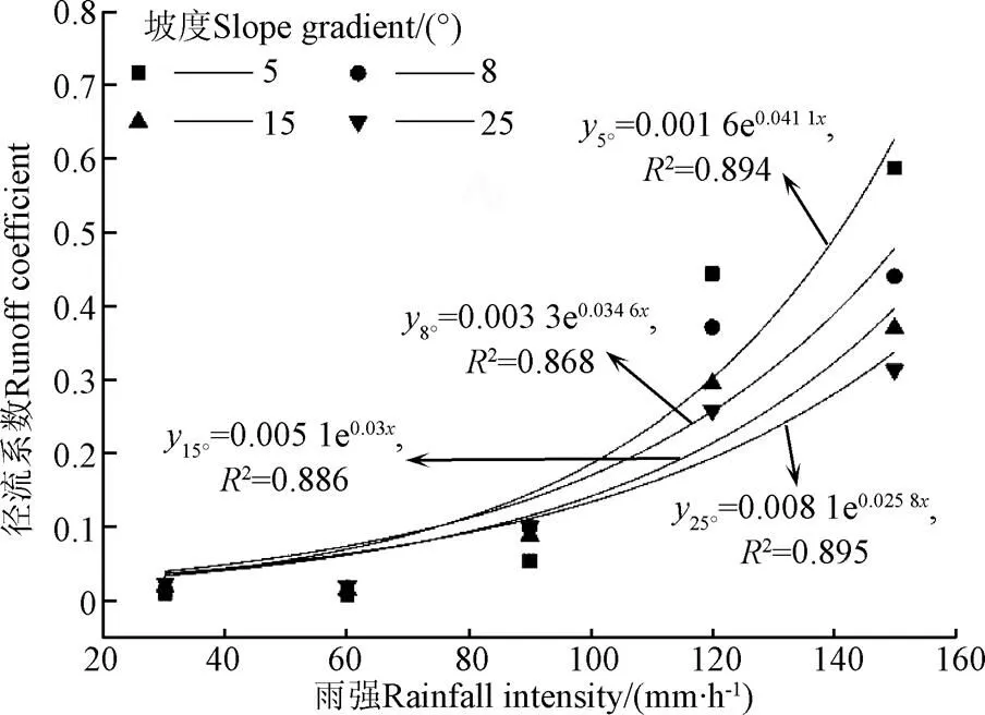
圖2 徑流系數隨雨強和坡度的動態特征曲線
徑流系數的大小取決于土壤的入滲強度,為了進一步分析造成坡面徑流量變化趨勢的原因,計算了不同條件下的降雨入滲速率并繪制過程曲線(圖3)。圖3顯示,降雨滲透率隨時間的延長先減小后趨于穩定,30、60和90 mm/h雨強下的入滲量比較大,產生的坡面徑流量較少。大雨強下的入滲率變化波動較為明顯,雨強150 mm/h時的最大入滲率出現在5°坡面,其他雨強條件下的最大入滲率出現在8°坡面。在本試驗設計情況下,影響降水入滲的主要因素是坡度和雨強。當雨強大于土壤的入滲強度時,一方面會形成超滲產流,同時,大雨強時雨滴的直徑大而且下落的終極速度隨之加大,對坡面土壤產生較大的打擊和濺蝕作用,導致坡面地表結皮,更容易形成坡面徑流。當雨強小于土壤的入滲強度時,雨滴的直徑較小、動能較低,對地表的擊濺侵蝕較弱,因而坡面產流量較小,主要以蓄滿產流為主,但由于被試驗土壤的砂粒含量較多,土壤的大孔隙比重較大,土壤滲漏嚴重,以壤中流的形式出流明顯,坡面徑流量較小。坡度不僅影響受雨面積,也影響到入滲水流的勢能和剪切力。在坡度較大時,受雨面積減小,在相同入滲的情況下,坡面徑流理論上應該呈減少的規律。但本試驗結果顯示為兩個變化趨勢,在雨強較小時(30、60 mm/h),是隨著坡度的增加而增加,當雨強大于90 mm/h時,隨坡度的增大而減小。90 mm/h雨強時,增減幅度不明顯,呈現為小波動。進而說明,坡度和雨強對土壤特性的綜合響應過程不同于單一要素的響應。
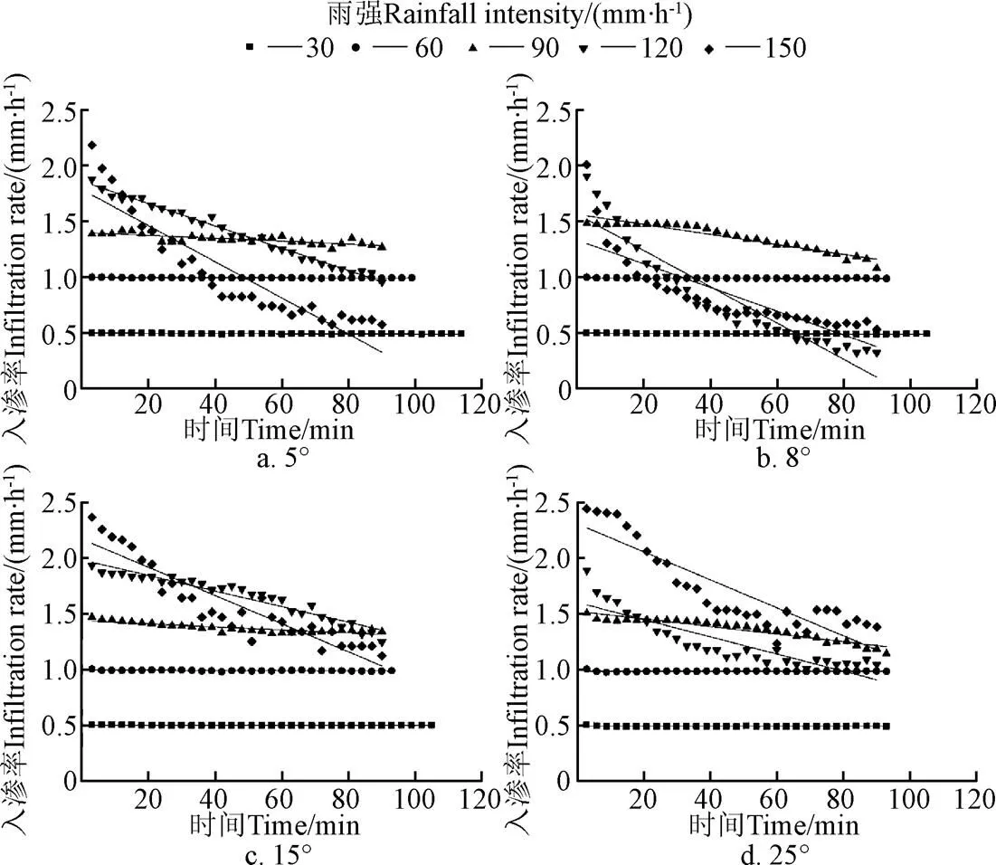
圖3 不同雨強和坡度下的坡面徑流入滲過程線
2.2 坡面侵蝕產沙特征
在雨強相同時,坡面徑流侵蝕產沙量隨坡度的增大而增大,其關系可以用冪函數表示(表2),回歸擬合的決定系數均達到0.815,表明該擬合式能夠很好地描述兩者之間的關系。雨強越大,侵蝕產沙量隨坡度增大的幅度越大,即回歸模型的斜率越大。在30 mm/h雨強時,坡面徑流的侵蝕產沙量很小,都沒有超過0.01 kg,坡度由5°增大到25°的坡面產沙量增幅為0.006 kg。雨強增大到60 mm/h時,產沙量增幅為0.049 kg,較前者大0.043 kg,雨強為90 mm/h時,產沙量隨坡度增大的增幅為0.812 kg,是雨強60 mm/h時的16.45倍,而雨強增大到120和150 mm/h時坡面侵蝕產沙增量對應為2.958和2.504 kg,分別是90 mm/h時的3.64倍和3.08倍。
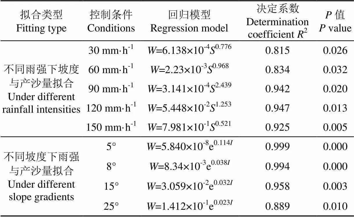
表2 交叉處理條件下產沙量與坡度和雨強之間的關系
注:表中代表產沙量,kg;代表坡度,(°);代表雨強,mm·h-1。
Note:stands for sediment yield, kg;stands for slope gradient, (°);stands for rainfall intensity, mm·h-1.
相同坡度條件下,產沙量隨著雨強的增大呈增大的趨勢,這與鄭子成等[34]對紫色土研究的結論一致,其關系可以用指數函數表示(表2),回歸模型決定系數均達到0.889,能夠較好地描述兩者之間的關系。而且模型的斜率隨著坡度的增大而增大,說明坡度越大時產沙量隨雨強的增幅越大。坡度5°~25°,降雨強度由30 mm/h增大到150 mm/h時,各坡度下產沙量的增幅依次為1.595、2.446、3.565和4.093 kg,表明坡度越大侵蝕產沙量隨雨強增加的速度越快,秦偉等[35]在紅壤裸坡地和馬星等[36]在紫色土坡耕地的研究也存在類似結論。
在表1數據基礎上,計算了徑流含沙量并繪制了含沙量與降雨強度的關系圖(圖4)。根據坡面徑流量的變化,大雨強時坡度5°條件下的坡面侵蝕產沙量理論上也應該最高,但試驗結果并非如此。這是因為降雨侵蝕并不完全等同于簡單的沖刷結果,土壤顆粒的分散、懸浮和搬運都是不同的物理作用過程,需用同時考慮平均含沙量、坡度和雨強的作用。相同雨強下平均含沙量隨坡度的變化過程表明,在雨強相同時坡面徑流的平均含沙量會隨著坡度的增大而增大。但是與產流過程相比,產沙過程更具有波動性和復雜性。在小于60 mm/h情況下,在坡度相同時,5°、8°和15°條件下坡面徑流的平均含沙量在60 mm/h時出現一個小峰值,但是5°坡地的平均含沙量遠小于其他的坡度,8°、15°和25°坡地的平均含沙量變化相近似,沒有表現出隨坡度增加而增加的現象。隨后,5°、8°和15°坡度在60~90 mm/h之間各坡度的平均含沙量顯示為遞減的趨勢。在雨強為90 mm/h時,坡度為5°、8°和15°出現了平均含沙量下降的畸值,而25°的坡地呈現為直線上升。大于90 mm/h的所有雨強,在4個設計坡度的情況下,幾乎都呈現為直線上升,只不過上升率以25°最大。這表明侵蝕性風化花崗巖坡面地區在雨強為60~90 mm/h之間存在一個侵蝕性臨界雨強。

圖4 不同坡度下平均含沙量隨雨強的變化
上述分析表明,在相同坡度的情況下,平均含沙量隨著雨強增大而呈現出增大的現象,這是因為較大的雨強能減少入滲,更快地產生地表徑流,地表徑流逐漸增多,對地表的沖刷就越強,攜帶走地表更多的泥沙,使沖刷量增加。雨強越大,雨滴動能和終極速度越大,對表層土壤結構的穩定性破壞越大,擊濺侵蝕加劇,而且短時間內在坡面迅速產生地表徑流沖刷土壤,進一步加劇土壤侵蝕。
坡面徑流攜帶泥沙顆粒特征取決于徑流的水動力學過程特征,其具體表現在所搬運泥沙的機械組成。為進一步研究降雨條件下坡地侵蝕產沙的機理,根據國際制粒級劃分標準將降雨后的侵蝕泥沙樣和降雨前的原始土顆粒情況進行對比(圖5)。由于強烈的侵蝕,使得發育于風化花崗巖母質上的土壤砂土層出露,砂粒含量的比重加大,所以增加了0.5、1 mm的粒級。結果表明,在侵蝕性風化花崗巖坡地,徑流侵蝕產生的泥沙主要為粒徑小于0.002 mm的黏粒、0.002~0.02 mm的粉粒以及0.02~0.2 mm之間的細砂粒,質量分數分別為16.70%、17.10%和14.15%,占總泥沙質量的47.95%,約為原始土質量分數26.95%的1.8倍,侵蝕泥沙的大砂粒和中砂粒(粒徑0.2~2 mm)含量明顯低于原始土的含量。這是因為粒徑較小的顆粒受雨滴擊濺容易起動,相對小的質量使之易于攜帶,因此降雨時間越長,小顆粒隨雨強增大的流失量越多。大顆粒泥沙不易起動和搬運,即使發生了起動也可能會在搬運過程中發生沉積,無法長距離移動,因此只有較少部分會流出坡面,這是徑流分選搬運作用的結果。徑流侵蝕挾帶的泥沙中粉粒、黏粒以及細砂粒的含量較多,導致土壤物理性黏粒和團聚體大量被侵蝕,造成了坡地土壤粗化,土壤肥力下降。分析其作用機制,土壤侵蝕量隨徑流流量的增大而增大[32],雨水沖擊淺層徑流,會在流動中產生顆粒云,沉降速度低于徑流速度的顆粒沉降到初始撞擊區下游的表面,這些顆粒向下游移動的距離由流速、顆粒在水中的沉降速度以及顆粒被懸浮的高度來決定。隨著徑流雷諾數的增加,水流從層流轉為紊流,雨滴沖擊造成的干擾持續時間足以使整個水流受到紊流的影響,而不僅僅是作用于孤立的沖擊地點,也就表明了受到雨滴擊濺擾動影響的淺層徑流侵蝕能力遠大于無雨滴擊濺影響的淺層徑流。
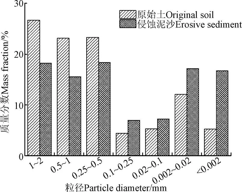
圖5 侵蝕泥沙樣和原始土的粒徑分布
2.3 坡面徑流侵蝕產沙影響因素擬合
根據表1試驗統計數據分析可知,徑流量與產沙量呈現出明顯直線正相關性,相關系數達到了0.807。采取跨坡度的雨強與產沙量擬合分析,二者呈現為指數規律,其相關系數也達到了0.885。同時,計算了不同雨強和不同坡度組合試驗的平均含沙量和徑流系數,并繪制了平均含沙量、徑流系數和總產沙量擬合曲線(圖6)。擬合結果表明總產沙量與平均含沙量之間為直線正相關關系,相關系數為0.709,表明在侵蝕量相同的情況下平均含沙量越大則總產沙量也就越大。總產沙量與徑流系數之間為指數函數關系,決定系數為0.727,也就是說徑流系數越大則總產沙量越多。坡度和雨強是侵蝕產沙的直接影響因素,在坡面復雜系統中,平均含沙量和徑流系數是雨強和坡度的直接體現。胡堯等[37]通過研究岷江流域紅壤坡面產流產沙發現坡面產沙主要受坡面徑流剪切力的影響,而徑流剪切力受坡度和雨強影響顯著,但是兩者之間不呈現單一的線性函數關系,變化規律不明顯。坡度和雨強都會對侵蝕產沙量產生一定的影響,但兩者之間的交互作用機制還有待進一步的研究探討。
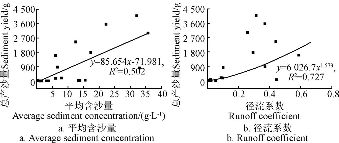
圖6 平均含沙量、徑流系數和總產沙量擬合曲線
為了進一步對比分析雨強、坡度和侵蝕產沙量之間的關系,使用SPSS21.0進行了相關性分析(表3)。結果表明侵蝕產沙量與雨強和徑流系數在0.01水平極顯著正相關,相關系數分別為0.783與0.642。含沙量和坡度與產沙量在0.01水平極顯著正相關,相關系數分別為0.728與0.718,含沙量和雨強在0.05水平顯著正相關,相關系數為0.449。徑流系數主要受雨強的影響,和雨強在0.01水平極顯著正相關,相關系數為0.890。綜上可知,侵蝕產沙量和含沙量同時受雨強和坡度的影響,但產沙量主要以雨強影響為主,而含沙量以坡度影響為主,含沙量的大小直接影響到產沙量的變化。將降雨過程中實測的數據利用SPSS 21.0進行回歸分析,得出擬合回歸方程模型

式中為侵蝕產沙量,g;為坡度,(°);為雨強,mm/h;為含沙量,g/L;為徑流系數。
回歸模型擬合度較好,模型方差分析表明統計量對應的值遠小于0.01,說明該模型整體是顯著的,坡度和雨強對于侵蝕性風化花崗巖坡地侵蝕產沙量的綜合影響可以用線性相關方程來比較準確地描述,模型決定系數為0.794。對產沙量的影響權重排序為:含沙量>雨強>徑流系數>坡度,雨強的系數為0.379比坡度的系數大,與相關分析的結論一致。同時采用SPSS 21.0中的因子分析法進行驗證,所得影響權重排序相同。
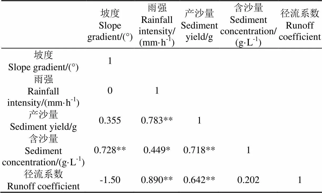
表3 坡面侵蝕產沙量、含沙量、徑流系數與坡度及雨強之間的關系
注:** 在 0.01 水平(雙側)上顯著相關;* 在 0.05 水平(雙側)上顯著相關。
Note: ** indicates significant difference at 0.01 (two-sided test); * indicates significant difference at 0.05 (two-sided test).
3 結 論
本文研究了不同雨強和坡度下侵蝕性風化花崗巖母質坡地產流產沙特征,結果表明:
1)強烈侵蝕的風化花崗巖坡地,土壤顆粒組成結構性差,降雨入滲強度大,所以坡面徑流在小雨強和緩坡情況下,徑流量少并增幅小。針對坡面徑流而言,其侵蝕性雨強的范圍分布在60~90 mm/h之間。
2)產沙量與徑流量關系密切,針對產沙來講,徑流含沙量對總產沙量的影響明顯。坡面徑流攜沙的分選作用,致使坡面粗化加重,粉粒和黏粒在泥沙中的富集程度較高,其黏粒的富集率能達到土壤的3倍以上。
3)通過產沙量與坡度、雨強、徑流系數和含沙量的相關擬合,其對產沙量的影響權重排序為:含沙量>雨強>徑流系數>坡度。
[1] Liu Dongdong, She Dongli, Yu Shuang'en, et al. Rainfall intensity and slope gradient effects on sediment losses and splash from a saline-sodic soil under coastal reclamation[J]. Catena, 2015, 128: 54-62.
[2] Shen Hai'ou, Zheng Fenli, Wen Leilei, et al. Impacts of rainfall intensity and slope gradient on rill erosion processes at loessial hillslope[J]. Soil and Tillage Research, 2016, 155: 429-436.
[3] Fu Suhua, Liu Baoyuan, Liu Heping, et al. The effect of slope on interrill erosion at short slopes[J]. Catena, 2011, 84(1/2): 29-34.
[4] 王麗園,查軒,黃少燕,等. 不同雨強條件下坡度對紅壤坡面侵蝕的影響[J]. 水土保持學報,2017,31(5):40-44.
Wang Liyuan, Zha Xuan, Huang Shaoyan, et al. Effect of slope gradient on red soil erosion under different rainfall intensity[J]. Journal of Soil and Water Conservation 2017, 31(5): 40-44. (in Chinese with English abstract)
[5] Kateb H E, Zhang Haifeng, Zhang Pingcang, et al. Soil erosion and surface runoff on different vegetation covers and slope gradients: A field experiment in Southern Shaanxi Province, China[J]. Catena, 2013, 105(5): 1-10.
[6] 和繼軍,蔡強國,劉松波. 次降雨條件下坡度對坡面產流產沙的影響[J]. 應用生態學報,2012,23(5):1263-1268.
He Jijun, Cai Qiangguo, Liu Songbo. Effects of slope gradient on slope runoff and sediment yield under different single rainfall conditions[J]. Chinese Journal of Applied Ecology, 2012, 23(5): 1263-1268. (in Chinese with English abstract)
[7] 張會茹,鄭粉莉. 不同降雨強度下地面坡度對紅壤坡面土壤侵蝕過程的影響[J]. 水土保持學報,2011,25(3):40-43.
Zhang Huiru, Zheng Fenli. Effect of slope gradients on erosion from a red soil hillslope under different rainfall intensity[J]. Journal of Soil and Water Conservation, 2011, 25(3): 40-43. (in Chinese with English abstract)
[8] Defersha M B, Melesse A M. Effect of rainfall intensity, slope and antecedent moisture content on sediment concentration and sediment enrichment ratio[J]. Catena, 2012, 90(3): 47-52.
[9] Ellison W D. Some effects of raindrops and surface-flow on soil erosion and infiltration[J]. Eos Transactions American Geophysical Union, 1945, 26(3): 415-429.
[10] 卜崇峰,蔡強國,程琴娟,等. 紫色土表土結皮發育特征的試驗研究[J]. 土壤學報,2007,44(3):385-391.
Bu Chongfeng, Cai Qiangguo, Cheng Qinjuan, et al. Development of soil crust on the surface of purplish soil[J]. Acta Pedologica Sinica, 2007, 44(3): 385-391. (in Chinese with English abstract)
[11] 汪邦穩,肖勝生,張光輝,等. 南方紅壤區不同利用土地產流產沙特征試驗研究[J]. 農業工程學報,2012,28(2):239-243.
Wang Bangwen, Xiao Shengsheng, Zhang Guanghui, et al. Study on runoff and sediment yield characteristics under different land uses in red soil area of Southern China[J]. Transactions of the Chinese Society of Agricultural Engineering (Transactions of the CSAE), 2012, 28(2): 239-243. (in Chinese with English abstract)
[12] 李桂芳,鄭粉莉,盧嘉,等. 降雨和地形因子對黑土坡面土壤侵蝕過程的影響[J]. 農業機械學報,2015,46(4):147-154.
Li Guifang, Zheng Fenli, Lu Jia, et al. Effects of rainfall and topography on soil erosion processes of black soil hillslope[J]. Transactions of the Chinese Society for Agricultural Machinery, 2015, 46(4): 147-154. (in Chinese with English abstract)
[13] Chen Shifa, Zha Xuan. Evaluation of soil erosion vulnerability in the Zhuxi watershed, Fujian Province, China[J]. Natural Hazards, 2016, 82(3): 1589-1607.
[14] 鄭粉莉,邊鋒,盧嘉,等. 雨型對東北典型黑土區順坡壟作坡面土壤侵蝕的影響[J]. 農業機械學報,2016,47(2):90-97.
Zheng Fenli, Bian Feng, Lu Jia, et al. Effects of rainfall patterns on hillslope erosion with longitudinal ridge in typical black soil region of Northeast China[J]. Transactions of the Chinese Society for Agricultural Machinery, 2016, 47(2): 90-97. (in Chinese with English abstract)
[15] 查軒,黃少燕,陳世發. 退化紅壤地土壤侵蝕與坡度坡向的關系:基于GIS的研究[J]. 自然災害學報,2010,19(2):32-39.
Zha Xuan, Huang Shaoyan, Chen Shifa. Relationship between erosion of degenerated red soil and terrain slope/aspect: A GIS-based research[J]. Journal of Natural Disasters, 2010, 19(2): 32-39. (in Chinese with English abstract)
[16] 胡建,郭太龍,卓慕寧,等. 華南紅壤坡面產流產沙過程模擬降雨試驗研究[J]. 生態環境學報,2013,22(5):787-791.
Hu Jian, Guo Tailong, Zhuo Muning, et al. Erosion processes on red soil slope in south China under simulated rainfall system[J]. Ecology and Environmental Sciences, 2013, 22(5): 787-791. (in Chinese with English abstract)
[17] 梁志權,卓慕寧,郭太龍,等. 不同雨強及坡度下坡面流的水動力特性[J]. 生態環境學報,2015,24(4):638-642.
Liang Zhiquan, Zhuo Muning, Guo Tailong, et al. Effects of rainfall intensity and slope gradient on hydrodynamic characteristics of overland flow[J]. Ecology and Environmental Sciences, 2015, 24(4): 638-642. (in Chinese with English abstract)
[18] 郝好鑫,郭忠錄,王先舟,等. 降雨和徑流條件下紅壤坡面細溝侵蝕過程[J]. 農業工程學報,2017,33(8):134-140.
Hao Haoxin, Guo Zhonglu, Wang Xianzhou, et al. Rill erosion process on red soil slope under interaction of rainfall and scouring flow[J]. Transactions of the Chinese Society of Agricultural Engineering (Transactions of the CSAE), 2017, 33(8): 134-140. (in Chinese with English abstract)
[19] 李軍鵬,董衛國,孟惠芳,等. 降雨條件下坡面細溝侵蝕模型及臨界坡度研究[J]. 災害學,2016,31(1):207-212.
Li Junpeng, Dong Weiguo, Meng Huifang, et al. Research of rill erosion model and critical slope gradient during rainfall[J]. Journal of Catastrophology, 2016, 31(1): 207-212. (in Chinese with English abstract)
[20] Hernandez M, Nearing M A, Al-Hamdan O Z, et al. The rangeland hydrology and erosion model: A dynamic approach for predicting soil loss on rangelands[J]. Water Resources Research, 2017, 53(11): 9368-9391.
[21] Choi K, Arnhold S, Huwe B, et al. Daily based morgan–morgan–finney (DMMF) model: A spatially distributed conceptual soil erosion model to simulate complex soil surface configurations[J]. Water, 2017, 9(4): 278.
[22] Martínez-Murillo J F, Nadal-Romero E, Regüés D, et al. Soil erosion and hydrology of the western Mediterranean badlands throughout rainfall simulation experiments: A review[J]. Catena, 2013, 106(9): 101-112.
[23] 馮秀,查軒,黃少燕. 人工模擬降雨條件下花崗巖紅壤坡面侵蝕過程與特征分析[J]. 中國水土保持科學,2014,12(1):19-23.
Feng Xiu, Zha Xuan, Huang Shaoyan. Processes and characteristics of erosion on hillslopes of granite red soil under simulated rainfall[J]. Science of Soil and Water Conservation, 2014, 12(1): 19-23. (in Chinese with English abstract)
[24] Magesh N S, Chandrasekar N. Assessment of soil erosion and sediment yield in the Tamiraparani sub-basin, South India, using an automated RUSLE-SY model[J]. Environmental Earth Sciences, 2016, 75(16):1208.
[25] 謝頌華,莫明浩,涂安國,等. 自然降雨條件下紅壤坡面徑流垂向分層輸出特征[J]. 農業工程學報,2014,30(19):132-138.
Xie Songhua, Mo Minghao, Tu Anguo, et al. Characteristics of vertical runoff output on red-soil slope under natural rainfall condition[J]. Transactions of the Chinese Society of Agricultural Engineering (Transactions of the CSAE), 2014, 30(19): 132-138. (in Chinese with English abstract)
[26] 陳曉安,楊潔,湯崇軍,等. 雨強和坡度對紅壤坡耕地地表徑流及壤中流的影響[J]. 農業工程學報,2017,33(9):141-146.
Chen Xiaoan, Yang Jie, Tang Chongjun, et al. Effects of rainfall intensity and slope on surface and subsurface runoff in red soil slope farmland[J]. Transactions of the Chinese Society of Agricultural Engineering (Transactions of the CSAE), 2017, 33(9): 141-146. (in Chinese with English abstract)
[27] 陳正維,劉興年,朱波. 基于SCS-CN模型的紫色土坡地徑流預測[J]. 農業工程學報,2014,30(7):72-81.
Chen Zhengwei, Liu Xingnian, Zhu Bo. Runoff estimation in hillslope cropland of purple soil based on SCS-CN model[J].Transactions of the Chinese Society of Agricultural Engineering (Transactions of the CSAE), 2014, 30(7): 72-81. (in Chinese with English abstract)
[28] 付興濤,張麗萍. 紅壤丘陵區坡長對作物覆蓋坡耕地土壤侵蝕的影響[J]. 農業工程學報,2014,30(5):91-98.
Fu Xingtao, Zhang Liping. Impact of slope length on soil erosion of sloping farmland with crop in red soil hilly region[J]. Transactions of the Chinese Society of Agricultural Engineering (Transactions of the CSAE), 2014, 30(5): 91-98. (in Chinese with English abstract)
[29] 阮伏水. 福建花崗巖地區坡度和坡長對土壤侵蝕的影響[J]. 福建師范大學學報:自然科學版,1995(1):100-106.
Ruan Fushui. Influence of inclination and length of slope on soil erosion in granite area of Fujian[J]. Journal of Fujian Normal University, 1995(1): 100-106. (in Chinese with English abstract)
[30] 周學軍,夏衛生. 衡山花崗巖地貌過程與水土流失關系的研究[J]. 農業工程學報,2005,21(增刊1):76-79.
Zhou Xuejun, Xia Weisheng. Relationship between granite geomorphic process and soil erosion of Hengshan Mountain[J]. Transactions of the Chinese Society of Agricultural Engineering (Transactions of the CSAE), 2005, 21(Supp.1): 76-79. (in Chinese with English abstract)
[31] 王秋霞,丁樹文,鄧羽松,等. 花崗巖崩崗區不同土層的侵蝕水動力學特征[J]. 土壤學報,2017,54(3):570-580. Wang Qiuxia, Ding Shuwen, Deng Yusong, et al. Hydrodynamic characteristics of erosion in different soil layers in granite collapse region[J]. Acta Pedologica Sinica, 2017, 54(3): 570-580. (in Chinese with English abstract)
[32] 鄧羽松,丁樹文,劉辰明,等. 鄂東南花崗巖崩崗崩壁土壤水分特征研究[J]. 水土保持學報,2015,29(4):132-137.
Deng Yusong, Ding Shuwen, Liu Chenming, et al. Soil moisture characteristics of collapsing gully wall in granite area of Southeastern Hubei[J]. Journal of Soil and Water Conservation, 2015, 29(4): 132-137. (in Chinese with English abstract)
[33] 徐加盼,王秋霞,鄧羽松,等. 基于三維激光掃描技術的花崗巖風化土體侵蝕表面特征研究[J]. 水土保持學報,2016,30(2):14-19.
Xu Jiapan, Wang Qiuxia, Deng Yusong, et al. Study on characteristics of erosion surface on weathered granite soil based on three-dimensional laser scanning technology[J]. Journal of Soil and Water Conservation, 2016, 30(2): 14-19. (in Chinese with English abstract)
[34] 鄭子成,秦鳳,李廷軒. 不同坡度下紫色土地表微地形變化及其對土壤侵蝕的影響[J]. 農業工程學報,2015,31(8):168-175.
Zheng Zicheng, Qin Feng, Li Tingxuan. Changes in soil surface microrelief of purple soil under different slope gradients and its effects on soil erosion[J]. Transactions of the Chinese Society of Agricultural Engineering (Transactions of the CSAE), 2015, 31(8): 168-175. (in Chinese with English abstract)
[35] 秦偉,左長清,晏清洪,等. 紅壤裸露坡地次降雨土壤侵蝕規律[J]. 農業工程學報,2015,31(2):124-132.
Qin Wei, Zuo Changqing, Yan Qinghong, et al. Regularity of individual rainfall soil erosion in bare slope land of red soil[J]. Transactions of the Chinese Society of Agricultural Engineering (Transactions of the CSAE), 2015, 31(2): 124-132. (in Chinese with English abstract)
[36] 馬星,鄭江坤,王文武,等. 不同雨型下紫色土區坡耕地產流產沙特征[J]. 水土保持學報,2017,31(2):17-21.
Ma Xing, Zheng Jiangkun, Wang Wenwu, et al. Characteristics of the runoff and sediment yield of sloping farmland in the purple soil area under different rainfall patterns[J]. Journal of Soil and Water Conservation, 2017, 31(2): 17-21. (in Chinese with English abstract)
[37] 胡堯,侯雨樂,李懿. 模擬降雨入滲對岷江流域紅壤坡面產流產沙的影響[J]. 水土保持學報,2016,30(2):62-67.
Hu Yao, Hou Yule, Li Yi. Effect of infiltration under simulated rainfall on the runoff and sediment yield of red soil slope in the Minjiang River Valley of Sichuan[J]. Journal of Soil and Water Conservation, 2016, 30(2): 62-67. (in Chinese with English abstract)
Characteristics of runoff and sediment yield under different rainfall intensities and slope gradients in erosive weathered granite area
Deng Longzhou, Zhang Liping※, Fan Xiaojuan, Wu Yanhong, Sun Tianyu, Fei Kai
(,,310058,)
Slope gradient is not only one of the major factors affecting soil particle detachment and transport but also an important factor in universal soil loss equation. There is no unanimous conclusion about the influence of slope gradient and rainfall intensity on soil erosion at present. Soil erosion in the rainy and thin-soil area of southeast China, however, is serious and thus can not be overlooked. In order to study and solve the problem of water-soil erosion loss on the weathered granite sloping land, in this study, we investigated the erosion process of the soil developed from weathered granite parent materials under different rainfall intensities (30, 60, 90, 120 and 150 mm/h) and slope gradients (5°, 8°, 15° and 25°) with the method of indoor artificial rainfall simulation. Stratified soil samples from different profiles including 0-60 cm were collected and then put into the soil tanks (2.0 m length ×1.0 m breadth × 0.6 m height) every 5 cm respectively for controlling the original bulk density. The simulated rainfall had uniformity of above 80%, similar to natural rainfall in raindrop distribution and size. Two experiments were carried out for each treatment to ensure the test precision. Soil on the top 5 cm was replaced after each rainfall simulation and the soil moisture was monitored before the next experiment to ensure the same initial soil moisture. The total time for runoff and sediment collection on the slope was 90 min after the appearance of runoff and the mixed samples were collected every 3 min and measured for volume and then used for subsequent analysis. The rest of the sample was dried to measure the sediment yield. The erosive sediment yield equations under different cross treatment conditions were established. The critical rainfall intensity of soil erosion and the critical slope gradient where soil and water conservation should be strengthened were clarified in the study area. The results indicated that the starting time of runoff and erosive sediment occurrence on the sloping land advanced with the increasing slope gradient and rainfall intensity. There was no simple positive correlation between runoff and slope gradient, and the relationship between runoff coefficient and rainfall intensity could be expressed as a potential function. The maximum infiltration rate under 30-120 mm/h appeared at the slope gradient of about 8°.The erosive sediment yield increased with the increasing slope gradient and rainfall intensity, and the relationship between slope gradient and sediment yield could be expressed by a power function with determining coefficient reaching 0.815, while the determining coefficient of the exponential relationship between rainfall intensity and sediment yield reached 0.889. Water erosion was selective for sediment as the content of silt, clay and fine sand entrained by runoff was relatively rich, and there was a boundary of erosive rainfall intensity between 60-90 mm/h in the study area. The combined effect of slope gradient and rainfall intensity on erosive sediment yield could be more accurately described by a linear correlation equation and the weighting order of sediment yield was listed as follows: sediment concentration > rainfall intensity > runoff coefficient > slope gradient. Research on the impact of slope gradient and rainfall intensity on sloping land erosion would contribute to soil and water conservation in the erosive weathered granite area.
soils; erosion; runoff; weathered granite; artificial simulated rainfall; slope gradient; rainfall intensity; sediment yield
10.11975/j.issn.1002-6819.2018.17.019
S157.1
A
1002-6819(2018)-17-0143-08
2018-03-07
2018-07-25
國家自然科學基金項目(41471221)
鄧龍洲,男,博士生,主要從事土壤侵蝕與水土保持、水資源利用與保護研究。Email:11614056@zju.edu.cn
張麗萍,女,教授,博士生導師,主要從事土壤侵蝕與水土保持、農業面源污染研究。Email:lpzhang@zju.edu.cn
鄧龍洲,張麗萍,范曉娟,鄔燕虹,孫天宇,費 凱. 不同雨強和坡度下侵蝕性風化花崗巖母質坡地產流產沙特征[J]. 農業工程學報,2018,34(17):143-150. doi:10.11975/j.issn.1002-6819.2018.17.019 http://www.tcsae.org
Deng Longzhou, Zhang Liping, Fan Xiaojuan, Wu Yanhong, Sun Tianyu, Fei Kai. Characteristics of runoff and sediment yield under different rainfall intensities and slope gradients in erosive weathered granite area[J]. Transactions of the Chinese Society of Agricultural Engineering (Transactions of the CSAE), 2018, 34(17): 143-150. (in Chinese with English abstract) doi:10.11975/j.issn.1002-6819.2018.17.019 http://www.tcsae.org