基于Newmark模型的積石山6.2級地震滑坡快速評估
2024-01-01 00:00:00馬星宇王蘭民蒲小武許世陽
地震工程學報 2024年4期


摘要:2023年12月18日甘肅臨夏回族自治州積石山縣發生6.2級地震,引發大量的滑坡和崩塌等地質災害。基于黃土高原強震數據庫中2013年岷縣—漳縣6.6級地震的地震動記錄回歸分析所得的Newmark位移預測模型,利用震前精度為30 m分辨率地形以及1∶250萬地質圖等數據,考慮豎向地震加速度以及冬灌的影響,對距震中擴展100 km范圍內的地區進行滑坡危險性快速評估,并與震前地質災害分布以及震后遙感解譯和實地調查結果進行對比。研究結果顯示:靜態安全系數較低的區域更容易發生地質災害;滑坡危險區主要位于距震中27 km的范圍內,危險區內河道和分水嶺發育,地層以新近系和第四系為主,與已有研究結果的重合度較高。研究表明,Newmark位移法適用于積石山區域內的震后滑坡危險性評價,但其并未考慮土體液化的情況,低估了液化災害發生的危險程度。
關鍵詞:Newmark位移; 區域滑坡危險性分析; 豎向地震加速度; 快速評估
中圖分類號: P319文獻標志碼:A文章編號: 1000-0844(2024)04-0825-11
DOI:10.20000/j.1000-0844.20240310001
Rapid assessment of landslides induced by the Jishishan
MS6.2 earthquake based on Newmark modelMA Xingyu WANG Lanmin PU Xiaowu XU Shiyang(1. Key Laboratory of Earthquake Engineering and Engineering Vibration, Institute ofEngineering Mechanics, CEA, Harbin 150080, Heilongjiang, China;2. Key Laboratory of Loess Earthquake Engineering of CEA amp; Gansu Province, Lanzhou 730000, Gansu, China)Abstract: "On December 18, 2023, an MS6.2 earthquake hit Jishishan County, Linxia Hui Autonomous Prefecture, Gansu Province. This phenomenon induced numerous geological disasters, such as landslides and collapses. The Newmark displacement prediction model was first derived from the regression analysis of ground motion records of the 2013 Minxian-Zhangxian MS6.6 earthquake in the strong earthquake database of the Loess Plateau. Therefore, considering the vertical seismic acceleration and the influence of winter irrigation, a rapid assessment of landslide risk in the area within 100 km from the epicenter was conducted using 30-m resolution topography and a 1:2.5 million geological map before the earthquake. Assessment results were compared with the distribution of geological disasters before the earthquake and the results of remote sensing interpretation and field investigation after the earthquake. The comparative results reveal that areas with low static safety factors are prone to geological disasters. The landslide risk area is mainly located within 27 km from the epicenter, where the channels and watersheds are highly developed, and the strata mainly comprise Neogene and Quaternary formations, demonstrating high similarity to the existing research results. The study demonstrates that the Newmark displacement method is appropriate for assessing post-earthquake landslide risk in the Jishishan area. However, the Newmark displacement method overlooks soil liquefaction, thereby underestimating the degree of danger of liquefaction.
Keywords:Newmark displacement; regional landslide hazard analysis; vertical seismic acceleration; rapid assessment
0引言
滑坡作為地震誘發的主要次生災害之一,不僅能直接造成人員傷亡和財產損失,其產生的滑坡堆積體還會掩埋道路、堵塞河流,從而延緩救援進度,加劇震害損失[1-2]。2008年汶川地震、2010年玉樹地震以及2022年瀘定地震等多次強震均出現了滑坡掩埋村莊、堵塞救援道路的情況[3-5]。由此可知,震后區域滑坡危險性的快速評估對判斷受災區域和震后救援均具有極其重要的意義。目前,國內外針對震后區域滑坡危險性評估的方法較多,主要有層次分析法、權重分析法、數值模擬法、Newmark位移法以及機器學習方法等[6-8]。其中Newmark位移法具有物理力學機制明確、計算簡便以及所需參數較少等優點,尤其在研究區域缺少歷史災害目錄以及因天氣原因導致的遙感影像不清晰的條件下,Newmark位移法的優勢更為顯著[9]。
Newmark位移的計算方法主要有3種,分別為剛性塊體法、解耦以及耦合計算[10]。剛性塊體法為傳統的Newmark位移分析法,將滑體假定為剛體,當向下的地震加速度a超過臨界加速度ac時,滑體向下運動,對超過部分的a進行二次積分,獲得滑體累加位移[11]。解耦計算和耦合計算是對剛性塊體計算的改進,突破了滑體為傳統剛體的假定[12]。解耦計算分為兩個部分:首先假設沒有明確的滑移面,利用數值模擬程序計算土體在地震過程中相應滑體的平均加速度時程k;然后將k與ac進行比較,計算累計位移。耦合計算則更加復雜,將滑體的動力響應和位移一起分析,以考慮滑動位移對滑體地震動響應的影響[10]。相較于剛體位移方法,解耦和耦合計算適用于滑體厚度更深、更加復雜的情況[12-14]。在區域危險性分析中,須針對每一個柵格進行Newmark位移計算。但按照目前的臺站密度以及計算條件,嚴格的Newmark方法是不現實的[15]。因此,國內外研究人員在利用Newmark模型進行區域地震滑坡危險性分析時,多采用基于強震動記錄回歸得到的Newmark經驗模型進行分析[16]。由于解耦和耦合方法在計算時需要更為詳細的參數信息以及更加復雜的運算,盡管也有研究人員基于解耦或耦合的方法開發了相應區域的Newmark經驗模型[17-19],但上述兩種方法主要用于單體滑坡的地震位移計算[20-22]。在進行區域危險性分析時,大多都基于傳統剛性塊體假定,通過對已有強震動記錄進行回歸分析,得到不同的Newmark經驗模型[23-26],并取得了大量的應用成果[27-30]。
2023年12月18日23時59分,甘肅臨夏回族自治州積石山縣發生6.2級地震,震源深度為10 km。此次地震共造成151人死亡,980人受傷,同時誘發了許多的地質災害[31]。震后,許多研究人員基于實地調查和衛星影像對此次地震誘發的地質災害進行了分析,取得了一系列的研究成果。王立朝等[32]在震后甘肅、青海兩省地質災害隱患核查的基礎上,對積石山地震誘發地質災害的特征、控制因素、發展趨勢進行了分析,研究表明,地質災害主要分布于發震斷層附近,發育密度隨地震烈度增強而增大,且斷層上盤效應較為顯著。黃觀文等[33]基于實時全球導航定位系統(Global Navigation Satellite System,GNSS)和加速度數據,對遠場易發區滑坡潛在危害性進行了評估,發現積石山地震對距震源 64 km以內的滑坡易發區影響較大。陳博等[34]基于歷史滑坡清單以及峰值加速度(Peak Ground Acceleration,PGA)分布,利用支持向量機模型給出了此次地震誘發滑坡的概率以及空間分布,同時,基于地震前后的衛星影像實現了積石山地震誘發同震滑坡的應急識別,并對滑坡的影響因素進行了分析。鐵永波等[35] 采用地面調查、遙感解譯和空間疊加統計等方法,對積石山和瀘定地震地質災害發育分布特征和控災因子的差異性進行了研究。李為樂等[36]基于多源高分辨率遙感解譯和已有研究成果對比分析,初步揭示了該次地震地質災害的基本特征和發育分布規律。劉帥等[37]通過應急排查和野外調查,對震后積石山縣地質災害的基本類型、空間分布特征和發育規律進行了研究,同時,基于調查結果,利用隨機森林模型對積石山縣內的同震地質災害進行了易發性評價。郭富赟等[31]通過遙感解譯和實地調查,對此次地震誘發地質災害的類型、空間分布規律和發育特征進行了詳細研究。陳鵬等[38]基于合成孔徑雷達干涉測量(Interferometric Synthetic Aperture Radar,InSAR)和光學影像對積石山地震誘發地質災害進行解譯,共解譯以小型黃土滑坡為主的滑坡4 996處,且絕大部分位于震中距5~30 km的范圍內。劉曉杰等[39]基于遙感影像,采用機器學習方法,快速建立了積石山地震震后滑坡目錄,并給出了滑坡的分布特征。
由上可知,Newmark位移法具有物理力學機制明確、計算簡便、所需參數較少、不受滑坡清單以及遙感影像限制等優勢。本文利用黃土高原地震數據庫中2013年岷縣—漳縣6.6級地震強地震動記錄回歸分析所得的Newmark位移預測模型,基于震前30 m分辨率地形數據以及1∶250萬地質圖等資料,考慮豎向地震加速度以及冬灌的影響,對積石山震中擴展100 km范圍內的滑坡危險性進行評價,并與已有的調查結果進行對比。研究結果旨在為Newmark位移法在積石山地區的適用性、震后斜坡危險性評估、災后救援和重建提供較為科學的參考依據。
1區域地震地質概況
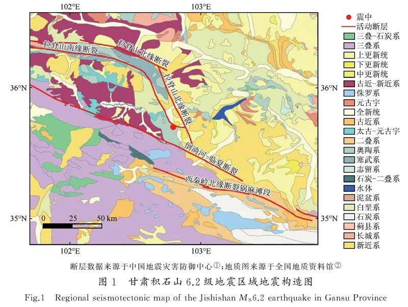
2023年積石山6.2級地震的震中位置為35.70°N、102.79°E,震源深度為10 km。此區域為甘東南活動構造區,屬于青藏高原東部南北地震帶[40]。區域內的主要活動斷裂有西秦嶺北緣斷裂、拉脊山斷裂帶以及倒淌河—臨夏斷裂等。此次地震為逆沖型地震,破裂面呈現SE—NW走向,發震斷裂為拉脊山北緣斷裂[41]。研究區出露的地層有前白堊系、古近系、新近系和第四系等。其中第四系地層較為完整,主要有下更新統(Qp1)、中更新統(Qp2)、上更新統(Qp3)以及全新統(Qh),主要分布于河流兩側、沖溝及盆地內。下更新統(Qp1)主要為五泉山組(下部為沖積礫石層,上部為洪積微膠結礫石層夾粉砂質黏土)。中更新統(Qp2)主要為黏質砂土、砂礫石層。上更新統(Qp3)主要為黃土、礫石層、亞砂土和亞黏土層。全新統(Qh)主要為沖洪積砂、礫石層以及亞砂土[42](圖1)。
2震后滑坡危險性快速評估
2.1Newmark模型基本原理
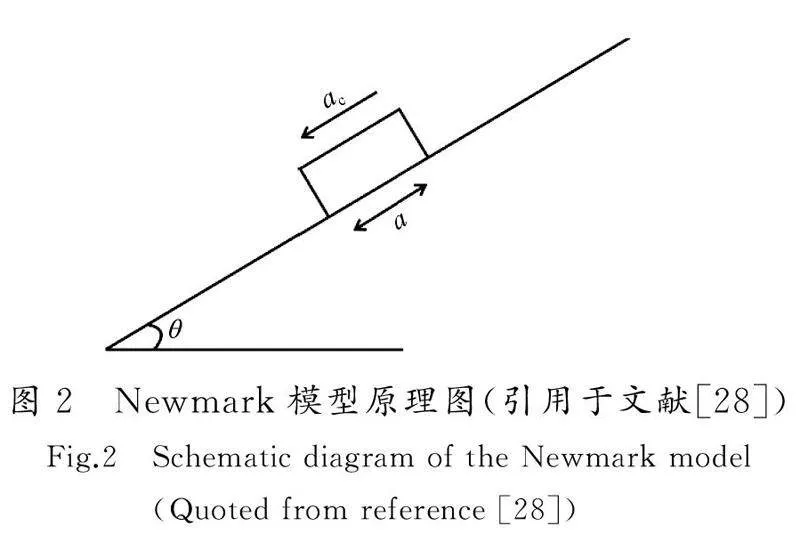
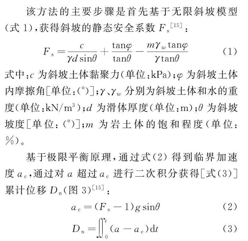
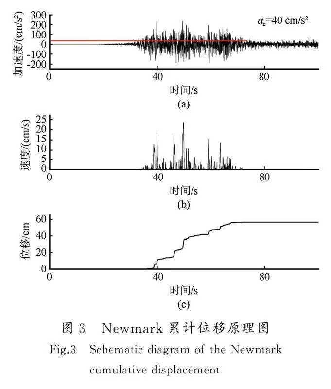
Newmark于1965年提出一種評價壩體地震穩定性的簡化模型。該模型將滑體簡化為剛體,認為滑體在地震作用下會沿著最危險的滑面運動,當向下的地震加速度a超過臨界加速度ac時,滑體向下運動,累加位移達到臨界狀態時,斜坡失穩[11](圖2)。
2.2靜態安全系數和臨界加速度
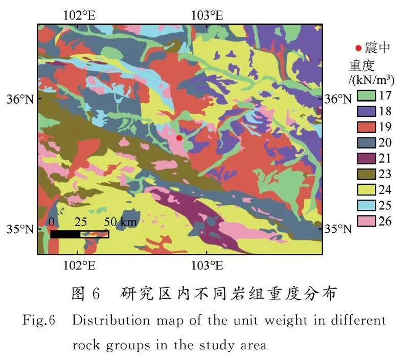
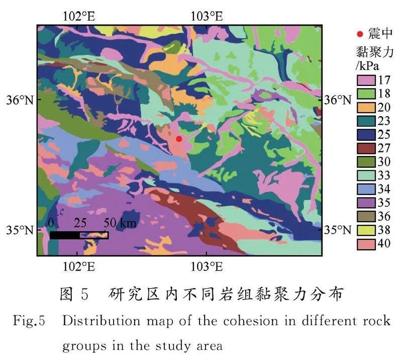
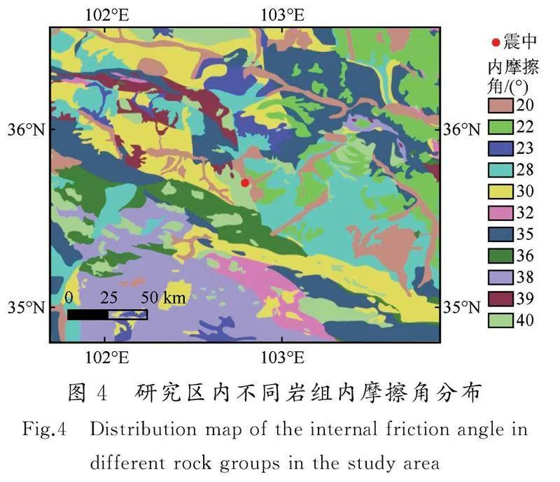
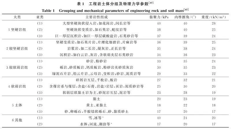
本文在1∶250萬公開版地質圖的基礎上(圖1),對積石山地震震中100 km范圍內的區域進行了工程地質分組。分類依據主要參考1∶250 萬地質圖以及前人研究結果[30]。不同巖組的物理力學參數按王濤等[43]的研究成果進行賦值(表1),賦值結果如圖4~6所示。
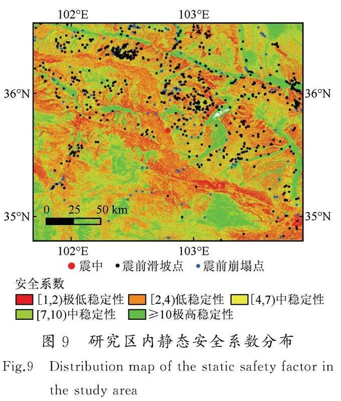
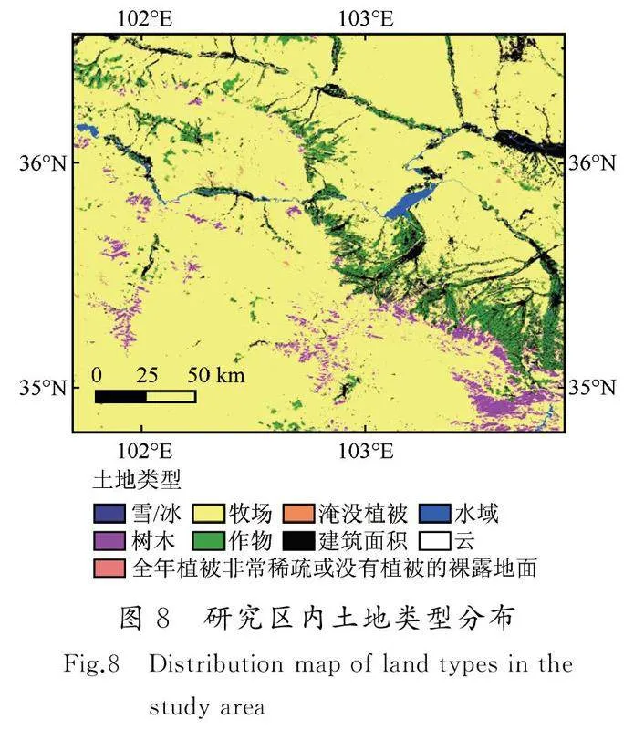
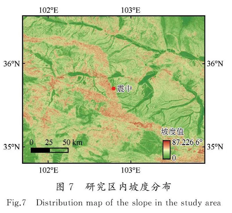
本文坡度數據由國家冰川凍土沙漠科學中心提供,分辨率為30 m,如圖7所示。根據式(1),基于ArcGIS平臺,對震中100 km范圍內區域的靜態安全系數進行計算。在計算過程中滑體厚度d取為3 m[30];由于震前未發生大規模的降雨,巖土體的飽和程度m取為0,但考慮到冬灌的影響,將有農作物的地區的m取為50%(圖8)。此外,在計算過程中出現了部分區域的安全系數小于1的情況,這是由于同一巖組包含不同的巖層,而在賦予參數時賦予了同樣的參數,這就導致部分地區的安全系數不符合實際情況。參照馬思遠等人的做法,將此部分區域的靜態安全系數賦值為1.01[27],所得結果如圖9所示。根據圖9可知,歷史災害點(滑坡和崩塌)主要分布于低穩定性和中穩定性的區域,表明巖體分組以及物理力學參數較為符合實際情況。通過靜態安全系數的分布,可以為工程選址以及災害預防提供一定程度的參考。在得到靜態安全系數的基礎上,利用式(2)獲取研究區域內臨界加速度的分布,如圖10所示。
2.3Newmark預測模型
已有的研究表明,基于強震動記錄回歸得到的位移模型具有區域相關性[24,44]。Newmark位移預測模型中,Ambraseys于1988年提出的模型參數最為簡單,僅有臨界加速度比一項,故其應用也較為廣泛[12,45]。本文在已有黃土高原地震數據庫的基礎上,基于震級、震中相近的原則,選取了2013年岷縣—漳縣6.6級地震的強地震動數據,對Ambraseys模型進行回歸分析。為提高信噪比,在計算前對強震動記錄進行基線校正和帶通濾波(帶通濾波的頻率為0.1~25 Hz)。選取臨界加速度ac為0.02g、0.05g、0.1g、0.15g、0.2g以及0.25g,對強震動記錄中的正向加速度超過臨界加速度ac的部分進行二次積分累加,獲得Newmark位移值(圖3)[44],擬合結果如圖11所示,擬合公式如下[式(4)]:
2.5Nemark地震位移分布
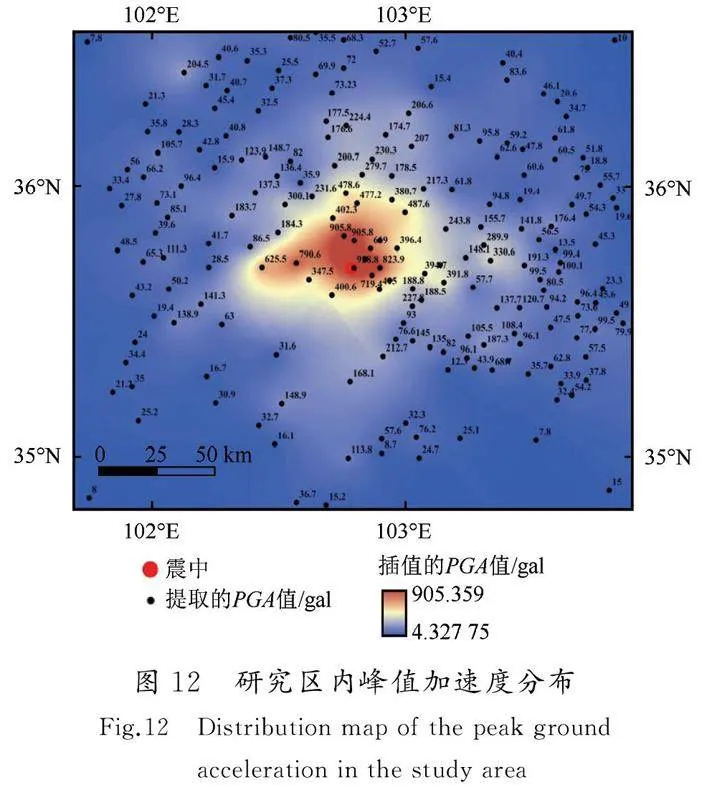
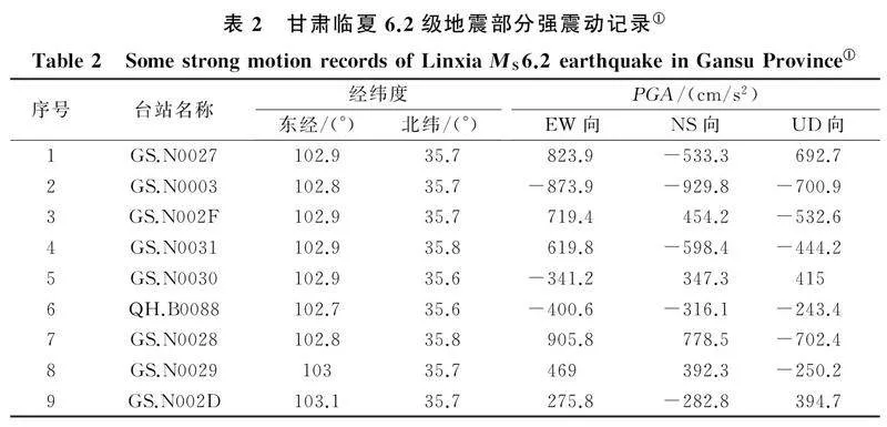
基于已得到的研究區域臨界加速度值和PGA值(圖10和圖12),利用式(4),對研究區內的累計Newmark地震位移進行計算。據已有的強地震動數據可知(表2),此次積石山地震的豎向加速度較大①。研究表明,當豎向地震加速度較大時,會對Newmark位移值產生較大影響。因此,在利用式(4)得到區域Newmark位移值后,采用式(5)對其進行修正[46]:
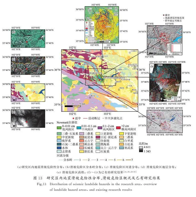
危險區、中危險區、高危險區以及極高危險區[15] [圖13(a)],并將其與已有的調查研究結果進行對比[圖13(f)~(i)][34,36,38-39]。由圖13(a)和圖13(f)~(i)可知,Newmark位移區主要位于距震中27 km的范圍內,與陳鵬等[38]基于InSAR 和光學影像解譯所得震中距范圍相符。Newmark位移區主要涉及積石山縣、循化撒拉族自治縣以及民和回族土族自治縣等,靠近震中位置的Newmark位移較大,但整體Newmark位移值偏小,表明此次地震災害主要以中小規模黃土滑坡和淺表層巖質崩塌為主,且崩塌的數量相對較多[31,36]。Newmark位移區沿斷層兩側分布,表現為受逆沖構造的“上下盤效應”[31]。已有的研究表明,河道以及分水嶺對滑坡具有較大的影響[48]。由圖13(b)和(c)可知,Newmark位移分布區內河道、分水嶺較為發育,表明此區域地形復雜。分水嶺處裂隙較為發育,結合此區域高程較大[圖13(e)]以及構造活動強烈等因素,可推測區域內的表面松散堆積物較為豐富,這為滑坡的發生提供了地形和物質基礎。由圖13(d)可知,Newmark位移主要分布區內主要以新近系(泥巖、雜黏土等)以及第四系(黃土、砂土等)為主,這是由于黃土具有較強的地震易損性,較易產生滑坡以及崩塌等地質災害。這也驗證了此次積石山地震誘發地質災害的空間特征為軟弱黃土地質環境的顯著控制[31]。
綜上可知,產生Newmark位移的區域與基于遙感影像解譯,以及實地調查所得范圍重合度較高,表明Newmark位移法在積石山區域具有較強的適用性。此外,圖13(a)中出現了一些零散柵格的Newmark位移值過大,這是由于強行對靜態安全系數小于1的區域賦值為1.01,對整體結果影響較小。此外,在地震中造成嚴重傷亡的青海省海東市民和縣永川鄉金田村和草灘村液化滑移災害并未被劃分成中高風險區,這是因為Newmark位移模型并未考慮土體液化的情況,低估了液化災害發生的風險。
3結論
本文基于2013年岷縣—漳縣6.6級地震強地震動記錄回歸分析所得的Newmark位移預測模型,利用震前30 m分辨率地形數據以及1∶250萬地質圖等數據,考慮豎向地震加速度和冬灌的影響,對距離積石山6.2級地震震中100 km范圍內的區域的滑坡危險性進行了評估,得出如下結論:
(1) 根據與已有災害點的對比,靜態安全系數較低的區域更容易發生地質災害,在工程建設中應采取相應的安全措施。
(2) 滑坡危險區內河道以及分水嶺較為發育、海拔較高、構造活動強烈、地層以第四系和新近系為主,為滑坡的發生提供了物質條件。
(3) 滑坡危險區與已有的調查結果重合度較高,表明Newmark位移法適用于積石山地區的震后滑坡危險性快速評估。在類似研究區域內缺少歷史災害目錄以及在震后因天氣原因導致的遙感影像不清晰的條件下,可采用Newmark位移法對震后滑坡危險性進行快速評估,用于判斷受災區域和指導救援。
(4) Newmark位移法未能考慮土體液化情況,低估了液化流滑災害發生的風險。
本文采用的研究區域的資料比例尺較大,研究的主要目的是驗證Newmark預測模型在積石山地區的適用性。隨著研究資料精度的提升,所得結果的準確度也將不斷增加。致謝:衷心感謝中國地震局工程力學研究所萬衛博士、彭達博士以及哈爾濱工業大學蘇浩然博士在資料收集和軟件使用中提供的幫助。感謝中國地震災害防御中心地震活動斷層探察數據中心(https://www.activefault-datacenter.cn)提供數據支撐。分析過程中使用的地形數據、歷史災害數據,及土地類型數據均由自國家冰川凍土沙漠科學中心提供,1∶250 萬地質圖來源于全國地質資料館,在此一并表示感謝。
參考文獻(References)
[1]黃潤秋.20世紀以來中國的大型滑坡及其發生機制[J].巖石力學與工程學報,2007,26(3):433-454.HUANG Runqiu.Large-scale landslides and their sliding mechanisms in China since the 20th century[J].Chinese Journal of Rock Mechanics and Engineering,2007,26(3):433-454.
[2]殷躍平.汶川八級地震地質災害研究[J].工程地質學報,2008,16(4):433-444.YIN Yueping.Researches on the geo-hazards triggered by Wenchuan earthquake,Sichuan[J].Journal of Engineering Geology,2008,16(4):433-444.
[3]崔鵬,韋方強,何思明,等.5·12汶川地震誘發的山地災害及減災措施[J].山地學報,2008,26(3):280-282.CUI Peng,WEI Fangqiang,HE Siming,et al.Mountain disasters induced by the earthquake of May 12 in Wenchuan and the disasters mitigation[J].Mountain Research,2008,26(3):280-282.
[4]許沖,徐錫偉,于貴華.玉樹地震滑坡分布調查及其特征與形成機制[J].地震地質,2012,34(1):47-62.XU Chong,XU Xiwei,YU Guihua.Study on the characteristics,mechanism,and spatial distribution of Yushu earthquake triggered landslides[J].Seismology and Geology,2012,34(1):47-62.
[5]蔡曉光,常晁瑜,李孝波.四川瀘定6.8級地震地質災害調查[J].防災科技學院學報,2022,24(4):11-22.CAI Xiaoguang,CHANG Chaoyu,LI Xiaobo.Investigation on seismic geological hazards of the Luding,Sichuan MS6.8 earthquake in 2022[J].Journal of Institute of Disaster Prevention,2022,24(4):11-22.
[6]PRADHAN B,MANSOR S,PIRASTEH S,et al.Landslide hazard and risk analyses at a landslide prone catchment area using statistical based geospatial model[J].International Journal of Remote Sensing,2011,32(14):4075-4087.
[7]KOHNO M,HIGUCHI Y,ONO Y.Evaluating earthquake-induced widespread slope failure hazards using an AHP-GIS combination[J].Natural Hazards,2023,116(2):1485-1512.
[8]HUANG D R,WANG G,DU C Y,et al.An integrated SEM-Newmark model for physics-based regional coseismic landslide assessment[J].Soil Dynamics and Earthquake Engineering,2020,132:106066.
[9]楊志華,張永雙,郭長寶,等.基于Newmark模型的尼泊爾MS8.1地震滑坡危險性快速評估[J].地質力學學報,2017,23(1):115-124.YANG Zhihua,ZHANG Yongshuang,GUO Changbao,et al.Landslide hazard rapid assessment in the MS8.1 Nepal earthquake-impacted area,based on Newmark model[J].Journal of Geomechanics,2017,23(1):115-124.
[10]JIBSON R W.Methods for assessing the stability of slopes during earthquakes:a retrospective[J].Engineering Geology,2011,122(1/2):43-50.
[11]NEWMARK N M.Effects of earthquakes on dams and embankments[J].Géotechnique,1965,15(2):139-160.
[12]RATHJE E M,BRAY J D.An examination of simplified earthquake:induced displacement procedures for earth structures[J].Canadian Geotechnical Journal,1999,36(1):72-87.
[13]BRAY J D,RATHJE E M.Earthquake-induced displacements of solid-waste landfills[J].Journal of Geotechnical and Geoenvironmental Engineering,1998,124(3):242-253.
[14]SONG J,LU Z X,JI J,et al.A fully nonlinear coupled seismic displacement model for earth slope with multiple slip surfaces[J].Soil Dynamics and Earthquake Engineering,2022,159:107353.
[15]王濤,吳樹仁,石菊松,等.基于簡化Newmark位移模型的區域地震滑坡危險性快速評估:以汶川MS8.0地震為例[J].工程地質學報,2013,21(1):16-24.WANG Tao,WU Shuren,SHI Jusong,et al.Case study on rapid assessment of regional seismic landslide hazard based on simplified Newmark displacement model:Wenchuan MS8.0 earthquake[J].Journal of Engineering Geology,2013,21(1):16-24.
[16]JIBSON R W.Predicting earthquake-induced landslide displacements using Newmark's sliding block analysis[J].Transportation research record,1993,1411:9-17.
[17]RATHJE E M,ANTONAKOS G.A unified model for predicting earthquake-induced sliding displacements of rigid and flexible slopes[J].Engineering Geology,2011,122(1/2):51-60.
[18]MACEDO J,BRAY J,TRAVASAROU T.Simplified procedure for estimating seismic slope displacements in subduction zones[C]//Proceedings of the 16th World Conference on Earthquake Engineering. Santiago:[s.n.],2017.
[19]DU W Q,WANG G,HUANG D R.Evaluation of seismic slope displacements based on fully coupled sliding mass analysis and NGA-West2 database[J].Journal of Geotechnical and Geoenvironmental Engineering,2018,144(8):06018006.
[20]MAKDISI F I,SEED H B.Simplified procedure for estimating dam and embankment earthquake-induced deformations[J].Journal of the Geotechnical Engineering Division,1978,104(7):849-867.
[21]BAZIAR M H,REZAEIPOUR H,JAFARIAN Y.Decoupled solution for seismic permanent displacement of earth slopes using deformation-dependent yield acceleration[J].Journal of Earthquake Engineering,2012,16(7):917-936.
[22]JI J,WANG C W,CUI H Z,et al.A simplified nonlinear coupled Newmark displacement model with degrading yield acceleration for seismic slope stability analysis[J].International Journal for Numerical and Analytical Methods in Geomechanics,2021,45(10):1303-1322.
[23]JIBSON R W.Regression models for estimating coseismic landslide displacement[J].Engineering Geology,2007,91(2-4):209-218.
[24]HSIEH S Y,LEE C T.Empirical estimation of the Newmark displacement from the Arias intensity and critical acceleration[J].Engineering Geology,2011,122(1-2):34-42.
[25]RAJABI A M,MAHDAVIFAR M R,KHAMEHCHIYAN M,et al.A new empirical estimator of coseismic landslide displacement for Zagros Mountain region (Iran)[J].Natural Hazards,2011,59(2):1189-1203.
[26]CHOUSIANITIS K,DEL GAUDIO V,KALOGERAS I,et al.Predictive model of Arias intensity and Newmark displacement for regional scale evaluation of earthquake-induced landslide hazard in Greece[J].Soil Dynamics and Earthquake Engineering,2014,65:11-29.
[27]馬思遠,許沖,王濤,等.應用2類Newmark簡易模型進行2008年汶川地震滑坡評估[J].地震地質,2019,41(3):774-788.MA Siyuan,XU Chong,WANG Tao,et al.Application of two simplified Newmark models to the assessment of landslides triggered by the 2008 Wenchuan earthquake[J].Seismology and Geology,2019,41(3):774-788.
[28]JIBSON R W,HARP E L,MICHAEL J A.A method for producing digital probabilistic seismic landslide hazard maps[J].Engineering geology,2000,58(3-4):271-289.
[29]陳曉利,單新建,張凌,等.地震誘發滑坡的快速評估方法研究:以2017年MS7.0九寨溝地震為例[J].地學前緣,2019,26(2):312-320.CHEN Xiaoli,SHAN Xinjian,ZHANG Ling,et al.Quick assessment of earthquake-triggered landslide hazards:a case study of the 2017 MS7.0 Jiuzhaigou earthquake[J].Earth Science Frontiers,2019,26(2):312-320.
[30]劉甲美,王濤,杜建軍等.四川瀘定MS6.8地震誘發崩滑災害快速評估[J].水文地質工程地質,2023,50(2):84-94.LIU Jiamei,WANG Tao,DU Jianjun,et.al.Emergency rapid assessment of landslides induced by the Luding MS6.8 earthquake in Sichuan of China[J].Hydrogeology amp; Engineering Geolog Y,2023,50(2):84-94.
[31]郭富赟,張永軍,竇曉東,等.甘肅積石山MS6.2地震次生地質災害分布規律與發育特征[J].蘭州大學學報(自然科學版),2024,60(1):6-12.GUO Fuyun,ZHANG Yongjun,DOU Xiaodong,et al.Distribution patterns and development characteristics of secondary geological hazards caused by the MS6.2 earthquake in Jishishan,Gansu[J].Journal of Lanzhou University (Natural Sciences),2024,60(1):6-12.
[32]王立朝,侯圣山,董英,等.甘肅積石山MS6.2地震的同震地質災害基本特征及風險防控建議[J/OL].中國地質災害與防治學報,(2023-12-28)[2024-05-10].https://link.cnki.net/urlid/11.2852.P.20231228.1352.002.WANG Lichao,HOU Shengshan,DONG Ying,et.al.Basic characteristics of co-seismic geological hazards induced by Jishishan MS6.2 earthquake and suggestions for their risk control[J/OL].The Chinese Journal of Geological Hazard and Control,(2023-12-28)[2024-05-10].https://link.cnki.net/urlid/11.2852.P.20231228.1352.002.
[33]黃觀文,景策,李東旭,等.甘肅積石山6.2級地震對滑坡易發區的變形影響分析[J/OL].武漢大學學報(信息科學版),(2023-12-28)[2024-05-10].https://doi.org/10.13203/j.whugis20230490.HUANG Guanwen,JING Ce,LI Dongxu,et al.Deformation analysis of Jishishan MW6.2 earthquake on the landslide hazard area[J/OL].Geomatics and Information Science of Wuhan University,(2023-12-28)[2024-05-10].https://doi.org/10.13203/j.whugis20230490.
[34]陳博,宋闖,陳毅,等.2023年甘肅積石山MS6.2地震同震滑坡和建筑物損毀情況應急識別與影響因素研究[J/OL].武漢大學學報(信息科學版),(2024-01-02)[2024-05-10].https://doi.org/10.13203/J.whugis20230497.CHEN Bo,SONG Chuang,CHEN Yi,et al.Emergency identification and influencing factor analysis of coseismic landslides and building damages induced by the 2023 MS6.2 Jishishan (Gansu,China) earthquake[J/OL].Geomatics and Information Science of Wuhan University,(2024-01-02)[2024-05-10].https://doi.org/10.13203/J.whugis20230497.
[35]鐵永波,張憲政,曹佳文,等.積石山MS6.2和瀘定MS6.8地震地質災害發育規律對比[J].成都理工大學學報(自然科學版),2024,51(1):9-21,59.TIE Yongbo,ZHANG Xianzheng,CAO Jiawen,et al.Comparative research of characteristics of geological hazards induced by Jishishan (MS6.2) and Luding (MS6.8) earthquakes[J].Journal of Chengdu University of Technology (Science amp; Technology Edition),2024,51(1):9-21,59.
[36]李為樂,許強,李雨森,等.2023年積石山MS6.2地震同震地質災害初步分析[J].成都理工大學學報(自然科學版),2024,51(1):33-45,90.LI Weile,XU Qiang,LI Yusen,et al.Preliminary analysis of the coseismic geohazards induced by the 2023 Jishishan MS6.2 earthquake[J].Journal of Chengdu University of Technology (Science amp; Technology Edition),2024,51(1):33-45,90.
[37]劉帥,何斌,王濤,等.甘肅積石山縣MS6.2地震同震地質災害發育特征與易發性評價[J/OL].地質力學學報,(2024-02-04)[2024-05-10].https://link.cnki.net/urlid/11.3672.P.20240202.1443.002.LIU Shuai,HE Bin,WANG Tao,et al.Development characteristics and susceptibility assessment of co-seismic geological Hazards in Jishishan MS6.2 earthquake,Gansu Province[J/OL].Journal of Geomechanics,(2024-02-04)[2024-05-10].https://link.cnki.net/urlid/11.3672.P.20240202.1443.002.
[38]陳鵬,邱梁才,姚宜斌,等.基于InSAR和光學影像解譯的2023年甘肅積石山MS6.2震后地表形變和災害分析[J/OL].武漢大學學報(信息科學版),(2024-04-19)[2024-05-10].https://doi.org/10.13203/j.whugis20240074.CHEN Peng,QIU Liangcai,YAO Yibin,et al.Surface deformation and hazard analysis after the 2023 MS6.2 earthquake in Jishishan,Gansu Province based on InSAR and optical imagery interpretation[J/OL].Geomatics and Information Science of Wuhan University,(2024-04-19)[2024-05-10].https://doi.org/10.13203/j.whugis20240074.
[39]劉曉杰,趙超英,李濱,等.基于InSAR技術的甘肅積石山震區活動滑坡識別與動態形變監測[J/OL].武漢大學學報(信息科學版),(2024-04-07)[2024-05-10].https://doi.org/10.13203/j.whugis20240054.LIU Xiaojie,ZHAO Chaoying,LI Bin,et al.Identification and dynamic deformation monitoring of active landslides in the Jishishan earthquake area,Gansu,China using InSAR technology[J/OL].Geomatics and Information Science of Wuhan University,(2024-04-07)[2024-05-10].https://doi.org/10.13203/j.whugis20240054.
[40]王潤妍,萬永革,宋澤堯,等.2023年12月18日甘肅積石山6.2級地震震源機制及其對周圍區域的應力影響[J].地震,2024,44(1):175-184.WANG Runyan,WAN Yongge,SONG Zeyao,et al.Focal mechanism and stress implication on the surrounding region of the Jishishan,Gansu MS6.2 earthquake on December 18,2023[J].Earthquake,2024,44(1):175-184.
[41]陸詩銘,吳中海,李智超.2023年12月18日甘肅省積石山6.2級地震的控震構造及特征[J].地震科學進展,2024,54(1):86-93.LU Shiming,WU Zhonghai,LI Zhichao.Seismic structure characteristics of the 18 December 2023 M6.2 Jishishan earthquake,Gansu Province[J].Progress in Earthquake Sciences,2024,54(1):86-93.
[42]張波.西秦嶺NWW向斷裂系的幾何圖像與變形分配[D].北京:中國地震局地質研究所,2020.ZHANG Bo.Fault geometry and deformation partition of WNW-trending faults in the West Qinling Mountain[D].Beijing:Institute of Geology,China Earthquake Administration,2020.
[43]王濤,劉甲美,栗澤桐,等.中國地震滑坡危險性評估及其對國土空間規劃的影響研究[J].中國地質,2021,48(1):21-39.WANG Tao,LIU Jiamei,LI Zetong,et al.Seismic landslide hazard assessment of China and its impact on national territory spatial planning[J].Geology in China,2021,48(1):21-39.
[44]徐光興,姚令侃,李朝紅,等.基于汶川地震強震動記錄的邊坡永久位移預測模型[J].巖土工程學報,2012,34(6):1131-1136.XU Guangxing,YAO Lingkan,LI Chaohong,et al.Predictive models for permanent displacement of slopes based on recorded strong-motion data of Wenchuan earthquake[J].Chinese Journal of Geotechnical Engineering,2012,34(6):1131-1136.
[45]AMBRASEYS N N,MENU J M.Earthquake-induced ground displacements[J].Earthquake Engineering amp; Structural Dynamics,1988,16(7):985-1006.
[46]DU W Q.Effects of directionality and vertical component of ground motions on seismic slope displacements in Newmark sliding-block analysis[J].Engineering Geology,2018,239:13-21.
[47]魏延坤,陳曉利.不同地震滑坡危險性評價方法的適用性探討:以瑪多MS7.4地震為例[J].地震地質,2022,44(3):590-603.WEI Yankun,CHEN Xiaoli.Applicability of different seismic landslide risk assessment methods:a case study of Maduo MS7.4 earthquake[J].Seismology and Geology,2022,44(3):590-603.
[48]DAHLQUIST M P,WEST A J,LI G.Landslide-driven drainage divide migration and quantifying progress toward topographic steady state[C]//AGU Fall Meeting Abstracts,2017:EP51B-1649.
(本文編輯:任棟)