Fostering spatial thinking skills for future citizens to support sustainable development
2021-11-07 04:30:34RobertKolvoord
科學文化(英文) 2021年1期
Robert A Kolvoord
James Madison University,USA
Abstract The United Nations Sustainable Development Goals (UNSDGs) represent the consensus of the global community on the most important issues facing our planet.A major challenge is embedding the UNSDGs in primary and secondary education and providing the tools needed for students to explore and analyse data relevant to the UNSDGs.The Geospatial Semester is a secondary school class in the United States that is focused on mastering geospatial technologies and using them to examine key problems of student interest,including the UNSDGs.Research studies show that the extended use of geographic information systems augments student problem solving and spatial thinking skills,particularly for females.Spatial thinking skills are a key gateway to science,technology,engineering and mathematics careers and an avenue to addressing the UNSDGs.
Keywords Geospatial technology,secondary education,spatial thinking,sustainable development
The United Nations Sustainable Development Goals(UNSDGs) (United Nations,2015) provide critical guidance for making our world more just and equitable.The level of interest in,and activity surrounding the goals suggests that they are galvanizing the attention of people in countries across the world,and there is substantial discussion about how to bring the goals more centrally into national educational systems (Commonwealth Hub,2017).
However,many of these efforts are informed by very traditional,discipline-focused thinking.The cross-cutting nature of the goals makes it very difficult for them to be addressed with a monodisciplinary set of knowledge and tools.There is a clear opportunity for innovation and disruption in primary and secondary school systems to bring about new approaches to address ‘wicked’ problems like those in the UNSDGs.
Technology has a major role to play in augmenting our educational pedagogy,specifically geospatial technology.These technologies allow students and teachers to visualize the impact of location on the UNSDGs and assess the affordances and challenges of place.Geospatial technologies continue to evolve dramatically and have become ubiquitous tools for decision-makers in almost all industries.However,their diffusion and use in primary and secondary classrooms have been much less impactful.
In this article,I discuss a spatial approach to education and to teaching the UNSDGs.I support the approach using examples from the research literature and share a variety of examples of student work.I also note the impact of the use of geospatial technologies on student learning.The article concludes by discussing the challenges and opportunities of using such an approach to meet the educational challenges of the UNSDGs.
1.The United Nations Sustainable Development Goals
The UNSDGs are almost a decade old,arising in their current form at the Rio Summit in 2012 and replacing the prior Millennium Development Goals.1 The UNSDGs broaden the focus beyond poverty,education and health in the developing world to focus on the need to sustain our planet while providing for equity across nations.The UNSDGs create a blueprint for the sustainability of our environment,our health and well-being,our families and our institutions.
While the SDGs cover the full range of human endeavours,there is a unifying theme in understanding our progress and challenges:geography.Analysing the UNSDGs and our progress in meeting them requires an approach that crosses national borders and allows us to look at the goals at a variety of spatial scales,from state/province to nation to region to continent to planet.This kind of approach requires a variety of geospatial tools,including remote sensing and geographic information systems (GIS),to acquire and analyse the data needed to assess our progress.In fact,the Sustainable Development Solutions Network recently introduced a new website and portal2 that features geospatially driven dashboards to assess global progress on the SDGs.
For instance,when assessing the size of the foodinsecure population or the fraction of the world’s population living in extreme poverty,there are clearly spatial patterns and strong correlations between goals (e.g.poverty and education).Figure 1 shows an example of one of the spatial dashboards.In this map,the scourge of desert locusts is displayed,showing the areas where they occur in large concentrations.In these areas,local farmers and communities are under severe stress to provide adequate food supplies for already food-insecure populations.Maps such as these provide decision-makers with the information they need to attend to incipient crises and to develop pathways to sustainable outcomes,ensuring that the UNSDGs can be met.
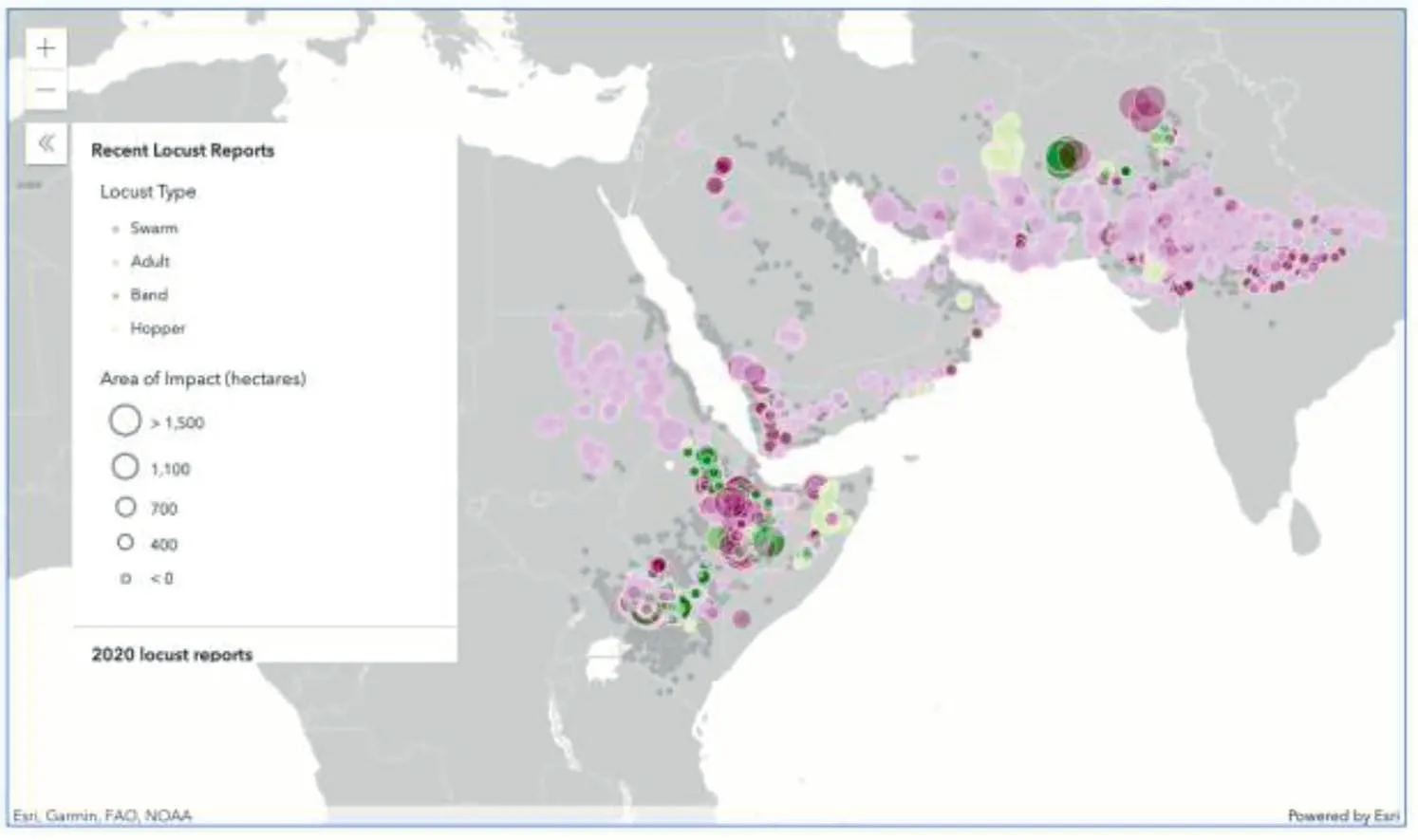
Figure 1. Map showing the concentration of desert locusts,courtesy of the Sustainable Development Solutions Network.
Clearly,the leaders of today see geospatial tools as a critical element in sustaining our planet,but what about the leaders of tomorrow?
2.Spatial thinking and science,technology,engineering and mathematics education
As we consider how to help the next generation of leaders and decision-makers develop geospatial thinking and reasoning skills,it is important to note that spatial reasoning skills are a critical element of success in science,technology,engineering and mathematics (STEM) careers.
Research by Wai et al.(2009),based on a longitudinal study over many decades,shows that individuals in STEM careers have higher spatial thinking skills than those in other careers (including teaching).However,this has not led to a strong focus on spatial thinking in primary and secondary curricula around the world (National Research Council,2006;Newcombe,2017),in spite of the fact that research shows that these skills are malleable and students can improve (Uttal et al.,2013),sometimes by substantial amounts.In fact,a report by the US National Academies states that ‘Spatial thinking is presumed throughout the K-12 curriculum but is formally and systematically taught nowhere’ (National Research Council,2006).This ‘tragedy of the commons’ is unfortunate,as it means that no one subject in a secondary school has responsibility to foster spatial thinking or GISs.
This lack of attention to spatial skill building,coupled with the lack of a large-scale introduction of geospatial technologies in primary and secondary education (Baker et al.,2015;Milson et al.,2012),leaves our current students ill-prepared for the work of attaining and monitoring the UNSDGs.However,there are a number of promising efforts to bring more geospatial technologies into curricula and provide students with the experiences they need to add these tools to their problem-solving arsenal.
3.Geospatial technology
Given the importance of spatial thinking in preparing those pursuing STEM careers and the central role that geography plays in the UNSDGs,it would be ideal to find a way to combine geography and technology in primary and secondary education.Geospatial technologies,such as GIS,meet this need and offer students an avenue to build their geographical understanding by analysing real data.In this paper,I examine a particular educational application of this technology:the Geospatial Semester.
The Geospatial Semester is an award-winning programme for secondary students in the United States wherein students learn about the use of GISs through applications to a variety of problems (including UNSDGs).It culminates in an extended project of each student’s choosing that requires them to specify the problem,gather relevant data,analyse those data and create a compelling presentation of their results (Kolvoord et al.,2019).Students can also earn college credit from James Madison University for their efforts.Inaugurated in 2005,more than 5000 students have participated in this programme in the last fifteen years.3
Figures 2 to 4 show example projects to provide a sense of the range of student interests.4
As the projects in Figures 2 to 4 show,the students are drawn to topics that are centred on the UNSDGs,particularly Goal 6–Clean Water and Sanitation,Goal 7–Renewable Energy,Goal 11–Sustainable Cities and Communities and Goal 13–Climate Action.They are able to create compelling pieces of research using geospatial technologies and communicate their findings to key stakeholders.In fact,Geospatial Semester students often work with external stakeholders as they do their projects,including local,state and national government agencies,non-governmental groups and private companies.Geospatial Semester students are learning by doing,developing real-world experiences with data and technology that lead them into higher education in a number of fields,including geography.However,does this work impact their spatial thinking skills?
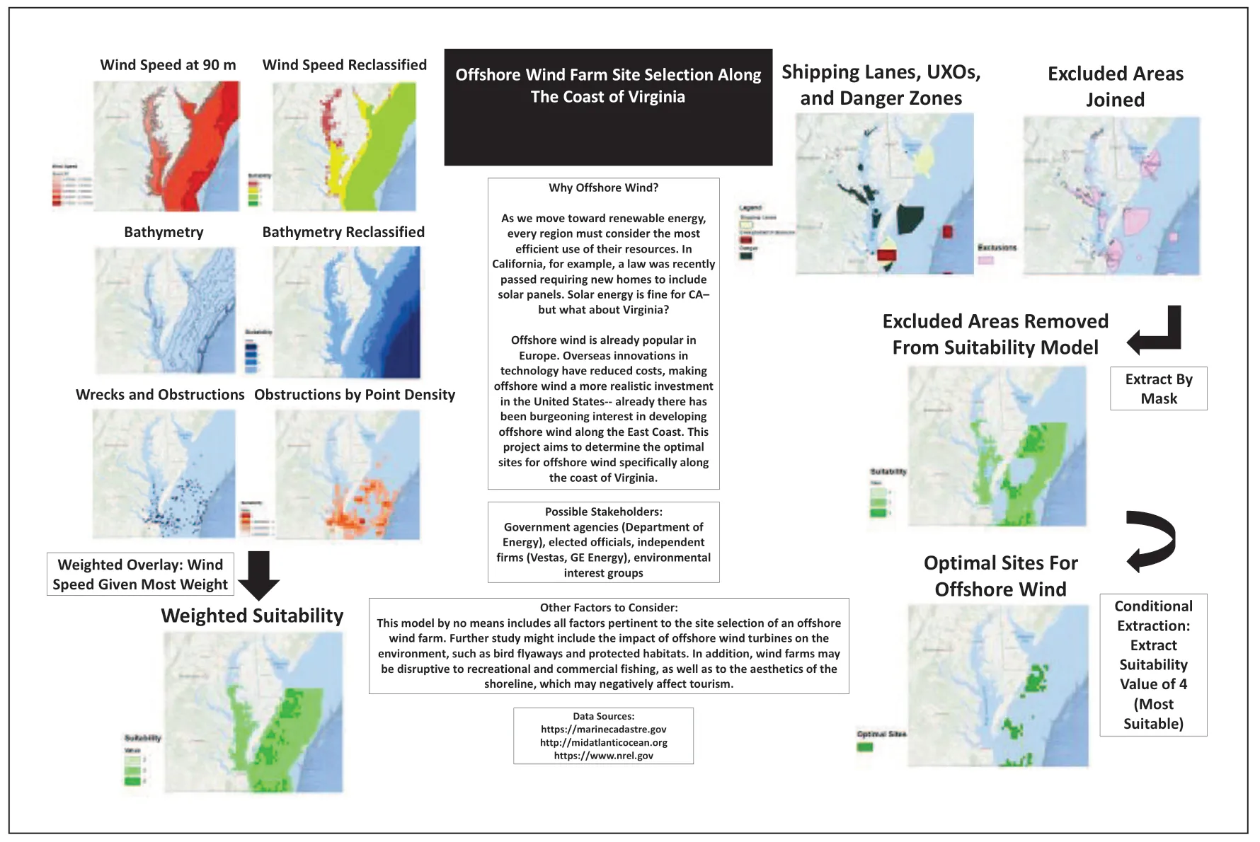
Figure 2. A project exploring possible factors in siting offshore wind turbines off the east coast of the United States.
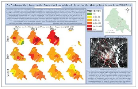
Figure 3. A project exploring ground-level ozone concentrations,a marker of air pollution,near a large city.
4.Spatial thinking and the Geospatial Semester
Through assessing student work with the Geospatial Semester,including the rich array of student projects,our team began to wonder if the use of GIS was making any difference in either their behaviour or their cognition.Like many other GIS in education projects,there were abundant anecdotes but little quantitative data.In order to develop a rigorous set of studies,we collaborated with psychologists at Northwestern University and Georgetown University.We conducted an array of studies to explore the impact of the Geospatial Semester on participating students and compared their performance with students who had not taken the Geospatial Semester.
In each study,we recruited students taking the Geospatial Semester class and similar students (same age,academic level and academic performance) not taking the class.In each study,we saw improved performance on a number of measures.We saw clear evidence of ‘21st century thinking skills’ (Charles and Kolvoord,2016) in students’ final projects.We also saw an increase in the use of spatial language and problem-solving skills(Jant et al.,2019),specifically in arguing from evidence and reasoning through a study that used video interviews at different points in the school year.
The most complete study combined behavioural and cognitive measures to examine the performance of Geospatial Semester participants and a comparison group chosen by using propensity score matching that assigns a ‘match’ from the non-Geospatial Semester students based on gender,academic performance and other demographic measures.This allows for a robust comparison group since a control group study is not possible in this setting.
In the behavioural measures,we saw improved efficiency in different spatial thinking measures(Mental Rotation Test and Embedded Figures Test),with a stronger effect for female students (Peterson et al.,2016).We also saw confirmation of the problem-solving findings from the study discussed above(Hollenbeck,2019).
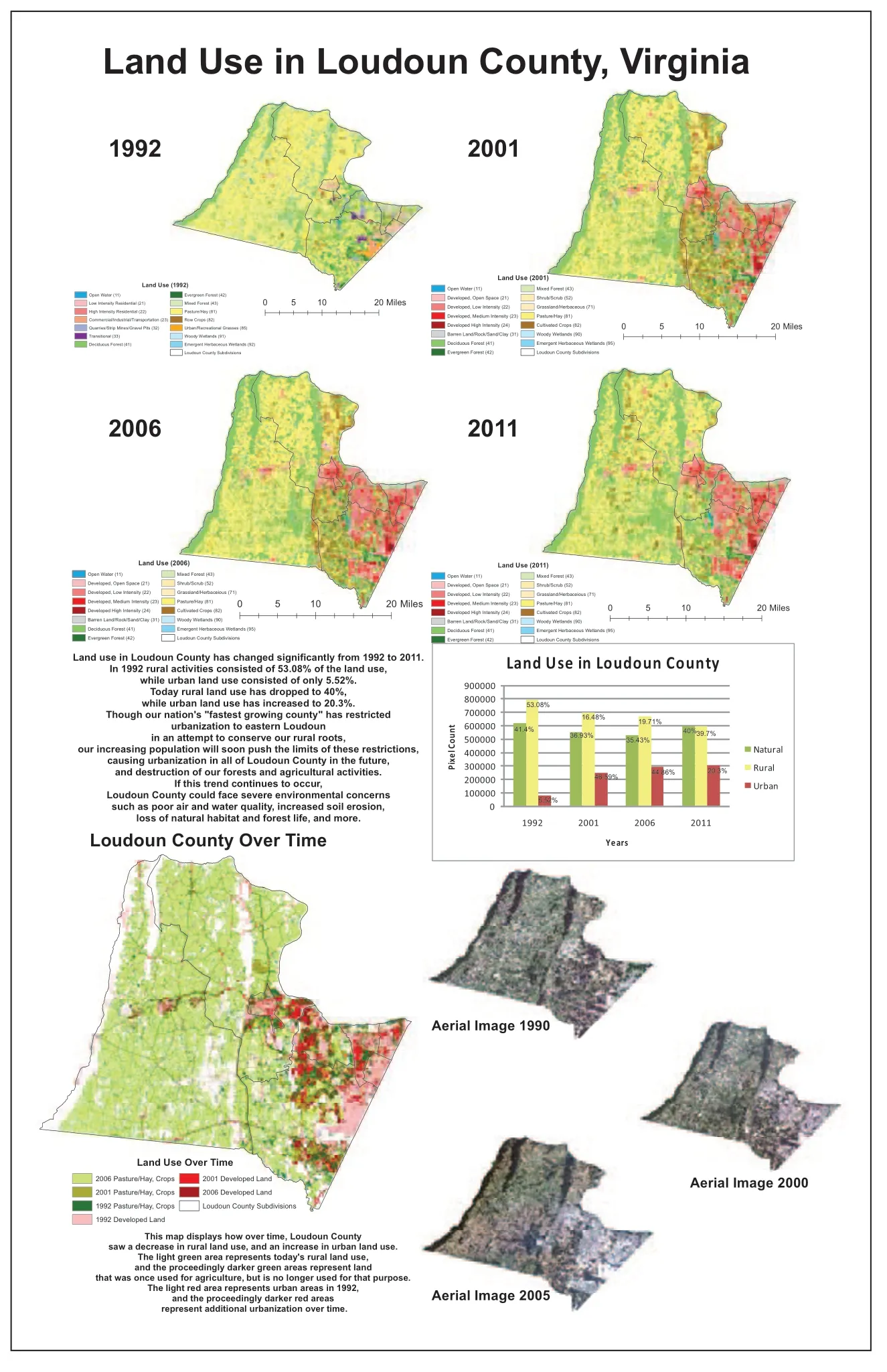
Figure 4. A project exploring the changes in a once rural area that has seen substantial development over the past 20 years due to its proximity to a large American city.
Along with the behavioural studies,we also conducted a cognitive study taking both Geospatial Semester students and comparison group students to the fMRI Center at Georgetown University and conducting brain scans.Although we are still in the process of analysing the data,preliminary results suggest that Geospatial Semester students show greater recruitment of spatial parts of the brain for non-spatial tasks and a stronger impact for female students (Cortes et al.,2021).
We were also able to explore parental attitudes towards students pursuing spatial careers (Muenks et al.,2019);the impact of student participation in spatial activities as youth and adolescents on spatial thinking skills (Peterson et al.,2020b);and the likelihood of pursuing a GIS course based on prior experience with GIS (Peterson et al.,2020a).Across all the studies,we saw a positive impact from pursuing the Geospatial Semester and an improvement in student spatial thinking skills,potentially opening opportunities for the pursuit of STEM careers.
5.Spatial thinking and the Sustainable Development Goals
The results obtained from students undertaking the Geospatial Semester suggest that the extended use of GIS can both augment student spatial thinking skills and promote a focus on the UNSDGs.The use of geospatial technology promotes the asking (and answering) of interdisciplinary questions that make up the UNSDGs in a way that standard curricula simply do not.The promotion of spatial thinking(and the possible opening of STEM careers) is a useful by-product.There is real opportunity in connecting GISs and the UNSDGs for students.
However,despite the many affordances of GIS use in secondary classrooms,a number of challenges arise.Teacher preparation programmes do not include any focus on either spatial thinking or geospatial technologies.In fact,in the United States,the UNSDGs often merit little attention.This is largely driven by a very siloed curriculum that is not easily shifted.In addition,computer access and technical support can be very uneven across schools.
As the UNSDGs gain more currency in education,geospatial technologies will continue to be a viable tool for analysis,visualization and communication.The growing ease of use of GIS,including a strong focus on mobile applications will level the access barrier and allow more classrooms to engage.Hopefully,societal pressures will more deeply infuse the UNSDGs in school curricula around the world.
6.Conclusion
We have shared an important technology application to facilitate secondary students in their work addressing the UNSDGs.Through the use of GIS,students can access and share data that bear on the SDGs.They can conduct analyses to understand global progress towards the UNSDGs and communicate their results with a variety of stakeholders.The continuing evolution of GIS promotes cloud-based collaboration and the integration of mobile data collection and sharing applications.This represents a tremendous opportunity for our students,but we will need to help the educational establishment embrace the tools and the UNSDGs.Even small steps could lead to significant progress around the world.We need to give students access to data and give them hope that we might one day meet the UNSDGs.
Acknowledgements
I want to acknowledge my collaborators Ms Kathryn Keranen and Mr Paul Rittenhouse of James Madison University,Dr Emily Peterson of American University,Dr David Uttal of Northwestern University,and Dr Adam Green of Georgetown University.I would like to thank the teachers and students of the Geospatial Semester for their ongoing efforts.I am also grateful to Professor Dongying Wei from Beijing Normal University.Finally,I wish to thank the Organizing Committee of the World Conference on Scientific Literacy for the invitation to address the meeting.
Declaration of conflicting interests
The author declared no potential conflicts of interest with respect to the research,authorship,and/or publication of this article.
Funding
The author received no financial support for the research,authorship,and/or publication of this article.
Notes
1.See the background of the UNSDGs at:https://www1.undp.org/content/seoul_policy_center/en/home/sustainable-development-goals/background/.
2.See https://www.unsdsn.org/.
3.More information on the Geospatial Semester is available at https://www.isat.jmu.edu/geospatialsemester/.
4.More student projects can be found at https://www.isat.jmu.edu/geospatialsemester/recognition.html.
- 科學文化(英文)的其它文章
- Building scientific capacity in disaster risk reduction for sustainable development
- Scientific literacy,public engagement and responsibility in science
- Working together to address global issues:Science and technology and sustainable development
- On the role of global change science in sustainable development:Reflecting on Ye Duzheng’s contributions
- Children as courseware collaborators:Using participatory research to produce courseware integrating science and sustainable development