面向滇中高原湖泊區地表覆蓋遙感探測的分類精度對比研究
2020-12-24 08:01:42易達李院瞧楊宇
軟件
2020年7期
易達 李院瞧 楊宇
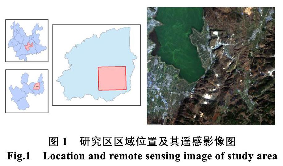


摘? 要: 遙感圖像分類是遙感信息提取的重要技術手段,目前已有多種遙感圖像分類方法運用在地表覆被分類中,而分類精度的提升是遙感數據處理及其應用的核心所在。因此,針對具體研究區環境特性,并通過比較分析各種遙感圖像分類方法的精度狀況,成為了如何選擇最合適遙感應用方法的根本依據。本文選取具有云南省滇中高原湖泊區域典型代表性的星云湖及周邊湖濱帶徑流區域為研究試驗區,通過采用監督分類、BP神經網絡分類和面向對象分類等三種遙感分類方法,開展研究區地表覆被類型的遙感圖像信息提取,并對三種方法所獲取結果的精度狀況進行對比分析研究。結果顯示,面向對象方法相對其余兩種方法更適用于星云湖流域土地利用分類。研究結果對于推進面向云南滇中高原湖濱帶地表覆蓋信息的遙感快速提取與動態監測具有現實科技指導作用,同時對研究云南滇中高原湖泊區域的資源環境利用與保護管理等具有重要的科學意義。
關鍵詞: 遙感監測;地表覆蓋;分類技術;精度評價;高原湖泊
中圖分類號: P237 ???文獻標識碼: A??? DOI:10.3969/j.issn.1003-6970.2020.07.009
本文著錄格式:易達,李院瞧,楊宇. 面向滇中高原湖泊區地表覆蓋遙感探測的分類精度對比研究[J]. 軟件,2020,41(07):45-50
Comparison of Accuracy of Land Cover Classification by RemoteSensing Monitoring Methods in Yunnan Plataea Lake Area
YI Da1, LI Yuan-qiao2, YANG Yu3
(1. Oxbridge College, Kunming University of Science and Technology, Kunming 650106, China;2. Yunnan Honghe Hydropower Survey and Design Institute, Kunming 650200, China;3. Faculty of Land Resources Engineering, Honghe 661100, China)
【Abstract】: Remote sensing classification is an important technology used for the extraction of information, there are varieties of remote sensing methods used in the classification, accuracy is the represent of the effect of classification which makes the improvement of accuracy become the core of remote sensing data processing and applications. Therefore, the analyst of accuracy by comparing the different classification methods in the specific study area has become the fundamental basis of remote sensing application. The typical representative area of Central Yunnan Plateau lakes region, Xing Yun lake and the runoff area were selected as study area in this paper. Three methods of unsupervised classification, BP neural network classification and object-oriented classification were used for the extraction of land cover information in remote sensing image, and comparing the three classification methods by accuracy evaluation. The results show that the object-oriented method is more suitable for land use classification in the Xingyun Lake Basin than the other two methods. There is practical guidance for the results in promoting quickly extraction and dynamic monitoring of land cover information, and important scientific significance for the study of resource and environment management, utilization and protection in Central Yunnan plateau lake.
【Key words】: Remote sensing monitoring; Land cover; Classification technology; Accuracy evaluation; Plateau lakes
0? 引言
通過遙感圖像識別各種地面目標是遙感技術發展的一個重要環節,無論是專題信息提取、動態變化監測、專題制圖、還是遙感數據庫建設等都離不開遙感圖像分類技術[1]。……
登錄APP查看全文
猜你喜歡
數學小靈通(1-2年級)(2021年4期)2021-06-09 06:25:56
人大建設(2020年4期)2020-09-21 03:39:12
初中生世界·七年級(2017年9期)2017-10-13 22:27:46
人大建設(2017年2期)2017-07-21 10:59:25
人大建設(2017年9期)2017-02-03 02:53:31
Coco薇(2016年2期)2016-03-22 02:42:52
Coco薇(2015年1期)2015-08-13 02:47:34
小雪花·成長指南(2015年4期)2015-05-19 14:47:56
浙江人大(2014年4期)2014-03-20 16:20:16