CORS技術在煤礦塌陷區土地復墾測量中的應用
2019-09-10 04:15:38汪六成戴洪寶許繼影
河南科技
2019年8期
汪六成 戴洪寶 許繼影
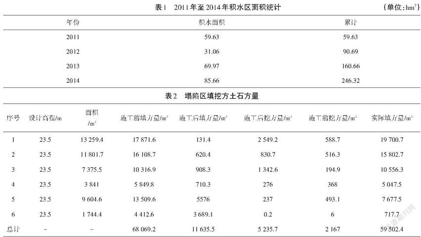
摘 要:隨著經濟的日益發展,煤礦開采力度不斷加大,而隨之而來的礦區塌陷問題也越來越嚴重。因此,做好礦區土地復墾工作成為當前要解決的一個重要問題。本文以淮北市任樓礦塌陷區土地復墾工程為例,結合CORS技術,對土地復墾測量中的控制測量、地形測量、土石方量計算等三個方面進行深入探討,并對煤礦塌陷區土地復墾工程進行總結,以期為相關工作提供借鑒。
關鍵詞:CORS技術;煤礦塌陷;土地復墾;土石方量
Abstract: With the development of economy, the mining intensity of coal mine is increasing, and the problem of mining area collapse is becoming more and more serious. Therefore, to do a good job of land reclamation in mining areas has become an important issue to be solved. Taking the land reclamation project in Renlou mine subsidence area of Huaibei City as an example, combined with CORS technology, this paper made an in-depth discussion on the control survey, topographic survey and earthwork calculation in land reclamation survey, and summarized the land reclamation project in coal mine subsidence area, with a view to providing reference for related work.
Keywords: CORS technology;coal mine subsidence; land reclamation;earthwork volume
1 CORS技術簡介
隨著GPS技術的飛速發展和應用普及,其在城市測量中的作用已越來越重要。當前,利用多基站網絡RTK技術建立的連續運行(衛星定位服務)參考站(Continuously Operating Reference Stations,CORS)已成為城市GPS應用的發展熱點之一。CORS系統是衛星定位技術、計算機網絡技術、數字通信技術等高新科技多方位、深度結晶的產物[1]。CORS系統由基準站網、數據處理中心、數據傳輸系統、定位導航數據播發系統、用戶應用系統五個部分組成,各基準站與監控分析中心間通過數據傳輸系統連接成一體,形成專用網絡。
CORS是“空間數據基礎設施”最為重要的組成部分,可以獲取各類空間的位置、時間信息及其相關動態變化[2]。通過建設若干永久性連續運行的GPS基準站,提供國際通用格式的基準站站點坐標和GPS測量數據,以滿足不同行業用戶對精度定位、快速和實時定位、導航的要求,及時地滿足城市規劃、國土測繪、地籍管理、城鄉建設、環境監測、防災減災、交通監控及礦山測量等多種現代化信息化管理的社會要求。……
登錄APP查看全文
