Flume experimental study on evolution of a mouth bar under interaction of floods and waves
2019-07-24 07:35:14LiYanMenwuWuYingChenYaoWuTianshengWu
Water Science and Engineering 2019年2期
Li Yan , Men-wu Wu ,*, Ying Chen , Yao Wu , Tian-sheng Wu
a Pearl River Hydraulic Research Institute, Pearl River Water Resources Commission, Guangzhou 510611, China
b Key Laboratory of the Pearl River Estuarine Dynamics and Associated Process Regulation, Ministry of Water Resources, Guangzhou 510610, China
c College of Harbor, Coastal and Offshore Engineering, Hohai University, Nanjing 210098, China
Abstract Based on the characteristics of hydrodynamics and sediment transport in the bar area in the Modaomen Estuary, a flume experiment was performed to study the evolution of the longitudinal profile of the mouth bar. The mouth bar evolution was investigated under the impacts of floods with different return periods as well as flood-wave interaction.The results showed that floods with different return periods had significant influences on the evolution of the river mouth bar. Particularly on the inner slope of the mouth bar, the sediment was substantially active and moveable.The inner slope and the bar crest tended to be remarkably scoured.The erosion was intensified with the increase of the magnitude of floods. Moreover, the bar crest moved seawards, while the elevation of the bar crest barely changed. Under the flood-wave interaction, a remarkable amount of erosion on the inner and outer slopes of the mouth bar was also found.The seaward displacement of the bar crest under the interaction of floods and waves was less than it was under only the impact of floods,while more deposition was found on the crest of the mouth bar in this case.
Keywords: Modaomen; Mouth bar; Wave; Flood; Flume experiment; Sediment transport
1. Introduction
Estuaries are located at the interface between fluvial and marine systems, which are generally characterized by highly economically developed regions with high populations. The river mouth is a region where fluvial suspended sediment deposits and shoals form.In general,the erosion and formation of bars and shoals are often affected by natural and artificial factors. Human activities, such as reservoir construction,large-scale reclamation, and embankment construction,permanently interfere with the morphology (Fagherazzi et al.,2015). Additionally, hydrodynamic factors, including runoff,sediment discharge, tides, and waves,lead to geomorphologic changes. These hydrodynamic factors play a vital role in sediment deposition at river mouths, which is associated with coastal erosion and land expansion(Kim,2012;Romans et al.,2016). Therefore, it is necessary to study the formation mechanism and the deposition pattern of the mouth bar(Nienhuis et al.,2016).The deposition regime in estuaries has been extensively studied in recent years. Many researchers in this field have studied the large-scale morphology of the whole estuarine environment(Sun et al.,2002;Edmonds et al.,2009;Canestrelli et al., 2014; Maloney et al., 2018).
It is important to explore the mechanisms of suspended sediment deposition and the formation of mouth bars in estuarine regions. Wright and Coleman (1974) used a fluid dynamics approach to investigate mouth bar formation, and considered it the deposit of an expanding,turbulent,sedimentladen jet plume. Based on Wright and Coleman's results,Edmonds and Slingerland (2007) described the development of the mouth bar as a sequence of aggradation and progradation. The physical processes controlling the evolution of the mouth bar often result from complex hydrodynamic factors, primarily including flooding, tides, and waves. Flooding laden with sediment experiences lateral spreading as a result of momentum exchange and bed friction when the flood debouches into the sea, expediting suspended sediment settling(Wright,1977;Kim,2012;Shaw et al.,2016).In addition,the tides (Leonardi et al., 2013; Hoitink and Jay, 2016), friction,and stability character of the jet(Canestrelli et al.,2014)have proven to be significant to the evolution of the longitudinal profile of a mouth bar. Furthermore, waves are an important driver that affects the mouth bar evolution (Nardin and Fagherazzi, 2012; Nardin et al., 2013a; Anthony, 2015).
In recent years, based on fluid and sediment transport patterns, numerical and physical models have helped reveal the impacts of hydrodynamic factors on the formation of river mouth bars. In fact, simulating geomorphological changes in the estuarine environment is widely recognized to be difficult for the current models due to various limiting conditions(Kuenzer et al., 2014). Nardin et al. (2013b) investigated the formation of river mouth bars under different conditions using the Delft3D numerical model. Physical modeling, however,provides a more direct way to reveal the intrinsic mechanism of the mouth bar formation and evolution (He et al., 2019).The Modaomen Estuary was used as an example in this study.It is a typical fluvial-dominated estuary,in which a significant river mouth bar has developed over decades. It is located in southern China and characterized by a micro-tidal region,with a large volume of runoff,strong waves,and plentiful sediment(Hu et al., 2005; Wang et al., 2008; Tan et al., 2013). The runoff and waves have a significant influence on the shaping of the mouth bar in the Modaomen Estuary. Based on a flume experiment, the characteristics of sediment transport were explored under the effects of floods and waves in this study.The impacts of floods, waves, and the flood-wave interaction on the evolution of the mouth bar in the Modaomen Estuary were further studied.
2. Overview of Modaomen Estuary
2.1. Hydrological and sediment features
The Pearl River is the third largest river in southern China,and its estuary constitutes the most prosperous region of the country(Mao et al.,2004).The Modaomen Estuary is the main outlet of the Pearl River,which has the largest discharge of the eight outlets of the Pearl River (Gong and Shen, 2011). Its mean annual discharge was 8.72 × 10¹⁰m3during the period of 1985-2000,accounting for more than 25%of the total flow from the Pearl River. The intra-annual distribution of runoff is extremely variable. According to long-term hydrological data,75.5% of the streamflow is concentrated in the wet season(April to September),but only 24.3%occurs in the dry season.Furthermore, the Modaomen Estuary is characterized by irregular semidiurnal tides with a mean annual tidal range of 0.86 m (Cai et al., 2012). Dawanshan Station wave field measurement data from 1996 to 2010 showed that the mean significant wave height was 1.5 m(MWRC,2006).In summer,southeasterly (SE) wind waves occur most frequently(57.75%), followed by east-southeasterly (ESE) (11.83%) and southerly (S) (10.09%) wind waves. Furthermore, the primary sediment types in the Modaomen Estuary are silt and clay.According to field measurements from October 2005, the median size of the suspended sediment in the Modaomen Channel is 0.007-0.018 mm. The surficial sediment mainly consists of silt with a median size of 0.0122 mm during the dry season and 0.0169 mm during the wet season.
2.2. Morphology
The Modaomen Channel expands from upstream, with a river width of about 1300 m at the Denglongshan Station, to the seaside (Hu et al., 2005). The mouth bar deposits at about 15 km from the Denglongshan Station. The inner slope of the mouth bar is 4.3%-27.5%, while the outer slope is about 12.0%-16.7%. Two deep channels, called the West Channel and the East Channel, are located at either side of the mouth bar, characterizing the estuary as a bifurcated configuration with a central bar and channels on either side(Jia et al.,2013)(Fig.1).The western trough is the main channel and subject to the impact of erosion. The mouth bar is also subject to mild erosion with a slightly decreasing elevation. The two troughs are roughly symmetrical and extend continuously towards the sea (Jia et al., 2015). Prior to 1995, considerable shoaling occurred in the Modaomen Estuary, including the Hezhou,Hengzhou,Xiaoxiangzhou,Jiaobeisha,and Shilanzhou shoals.After that,an important regulation of engineering works on the Modaomen Channel was implemented. Two leading dikes were built at both sides of the western and eastern troughs for the purpose of flood release and navigation (He et al., 2016).
3. Flume experiment
3.1. Model set-up
In order to explore the hydrodynamic characteristics and evolution of the river mouth bar, the evolution of the longitudinal profile of the mouth bar under the wave-current interaction was explored with a flume experiment. The bifurcation flow in the Modaomen Estuary was thus simplified as axial flow in the flume. According to the hydrodynamic characteristics of the study area and the length of the transition zone,the boundaries of the flume experiment were set between Dahengqin Island and 5 km outside the mouth bar crest (Fig. 1).
The flume was 65 m long, 1 m wide, and 1.2 m deep,equipped with a wave maker and water pumps.Eight measuring points for flow velocity marked as V1 through V8, two measuring points for water depth,and two measuring points for wave height were set in the experimental flume, as shown in Fig.2.A closed,circulatory flow system was used to control the flow pattern in the flume experiment. The water pump,controlled by a frequency converter, was used to adjust the magnitude of flow. On a side of the flume, an irregular wave maker was equipped with a device for wave generation. The motions of a wave maker paddle were controlled by the wave signal input from a computer.With a sufficient number of tests performed, regular waves and irregular waves with different spectrums were generated in the flume experiment.The data of the flume experiment were continuously derived and recorded using a wave-height gauge with a 25-Hz sampling frequency.
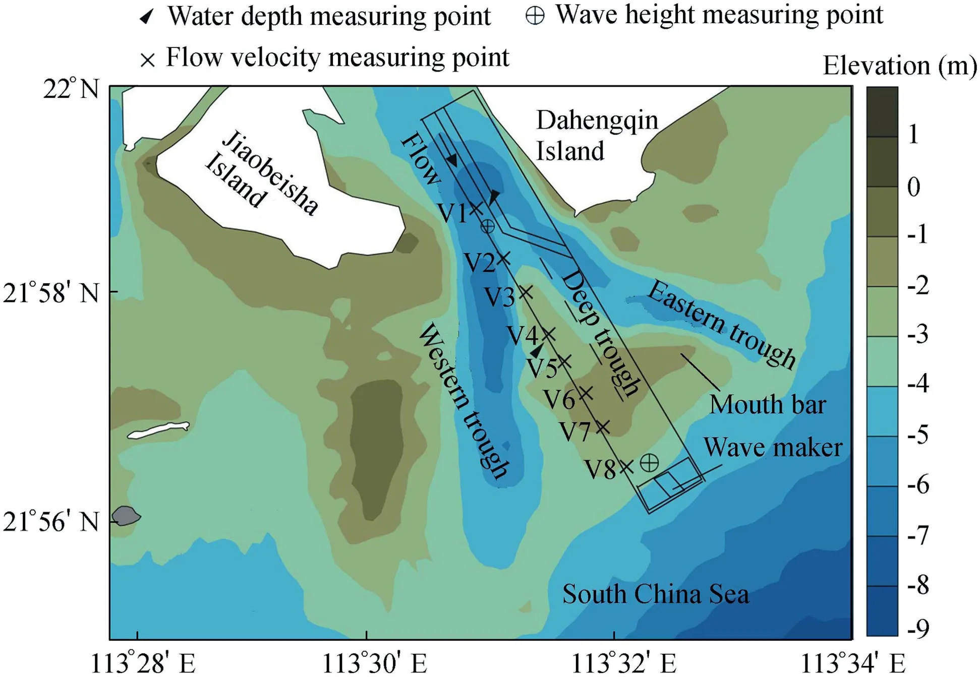
Fig. 1. Topographic map of Modaomen Estuary and layout of flume model.
With consideration of the interference of the wave refection and deflection, the flume experiment was designed by means of a distorted model, based on similarity of sediment movement.The plane and vertical scales were determined according to the size of the flume. In order to cover the longitudinal profile of the flume with a length of 65 m,in which the mouth bar had a length of about 20 m,the plane scale was set to 400.Considering the height of the flume (1 m) and the distortion ratio of 20, the vertical scale was set to 20. Other parameters,such as the velocity scale, roughness scale, time scale,discharge scale, and wave height scale were calculated using theoretical equations, and their values were 4.47, 0.37, 89.4,35777, and 20, respectively.
3.2. Selection of model sediment
According to the measured data from the Modaomen Estuary, the median size of the suspended sediment was about 0.007-0.018 mm. With consideration of flocculation and settling of fine sediment, the settling velocity was about 0.04-0.05 cm/s. Based on the similarity criteria, the settling velocity of the model sediment could be about 0.18-0.22 cm/s in the flume experiment.The calculated incipient velocity was about 0.42-0.71 m/s for a water depth of 1.5-5 m, which means that the incipient velocity in the flume experiment could be 9-15 cm/s.Therefore,plastic particles with a median diameter of 0.23 mm, specific gravity of 1.22 t/m3, settling velocity of 0.15 cm/s,and incipient velocity of 7-9 cm/s were used in this study.
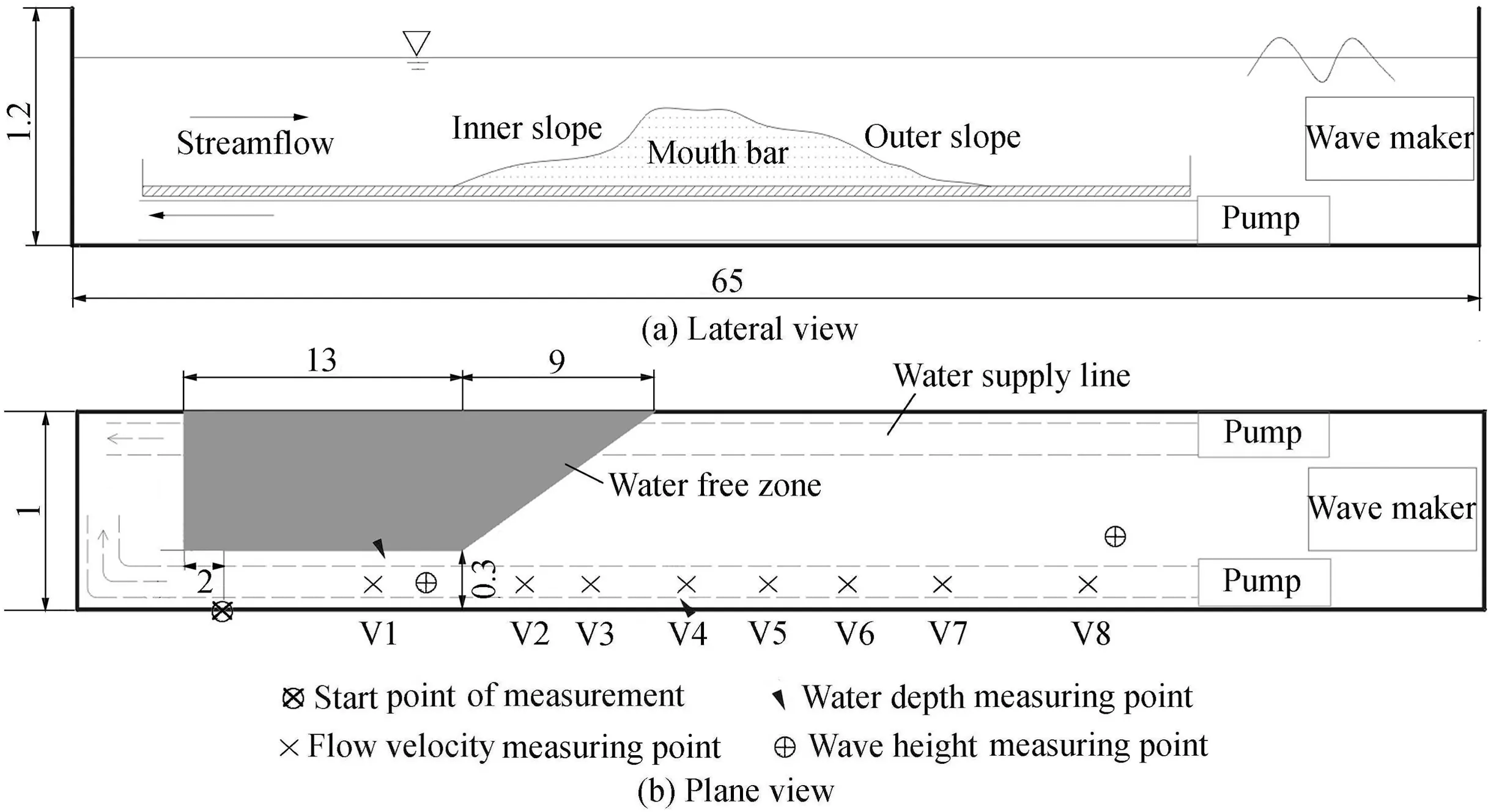
Fig. 2. Schematic diagram of flume model (units: m).
3.3. Model validation and experiment
3.3.1. Velocity validation
Due to the lack of available velocity data for typical flood processes, the results of the numerical model were used to determine the velocity in the flume experiment. The velocity in the region of the mouth bar was significantly lower than that at the entrance of the Modaomen Estuary as a result of the increment in the cross-section area. Based on the characteristics of changing velocity, the width of the river mouth in the flume experiment was set to 0.3 m at the entrance and increased stepwise to 1.0 m at the inner slope of the mouth bar.Moreover, the bar area and the water supply lines below were separated with a brick wall. The landform of the deep trough area can be adjusted to alter the flow velocity in the flume experiment.
The typical floods of June 2005 (with a return period of more than 100 years) and July 1999 (with a return period of about one year)were used to validate the longitudinal velocity in the flume experiment under the action of an ebb stream with the maximum velocity. Fig. 3 shows that the modeled results fit well with the field measurement data, with some slight errors, and thus the model was further used in the flume experiment. Additionally, the sediment utilized in the model was carefully chosen before the flume experiment according to the deposition scale and erosion scale. Considering the validation achieved for flow velocity, the sediment movement in the model was considered to be reasonable.
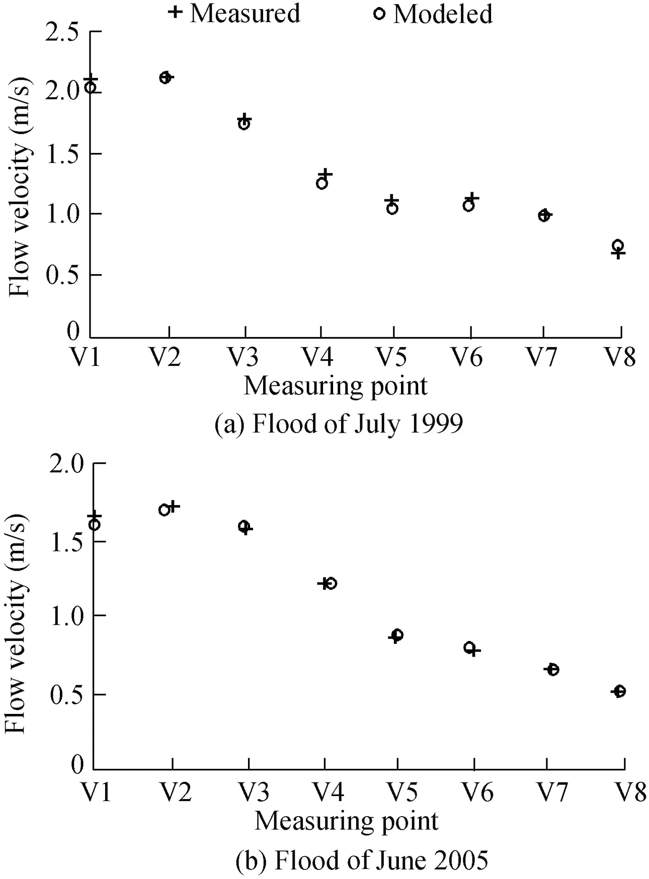
Fig. 3. Comparison of measured and modeled flow velocities under consumption of velocity scale of 4.47.
3.3.2. Experiments for sediment movement
The measured bathymetry of the Modaomen Estuary in May 2000 was set as the initial surface elevation in the model(using the bathymetry of the Pearl River as a reference).The impacts of floods and waves were simulated and compared in the experiment.The longitudinal profile of the mouth bar under the impact of the flood of July 1999 after five hours of modeling is shown in Fig.4(a)and Fig.5.Fig.4(a)clearly indicates that the sediment on the inner slope of the mouth bar was active. The sediment was transported in the form of bed load and suspended load. The surface of the inner slope experienced significant erosion while the outer slope and the crest showed minor changes (Fig. 5). In the meantime, continuous sand ripples appeared over the entire surface of the riverbed.
Subject to the effect of waves, the experiment was run for five hours under the condition of a 0.6-m wave height. Sediment was transported upstream under the impact of the deepwater wave. Furthermore, under the impact of the shallowwater wave, the bed load was lifted and subsequently moved upstream, giving rise to sediment accumulation at the crest of the mouth bar. The bed surface was smooth without sand ripples, as shown in Fig. 4(b) and Fig. 5.
4. Results and discussion
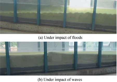
Fig. 4. Longitudinal profiles of mouth bar in flume experiment.
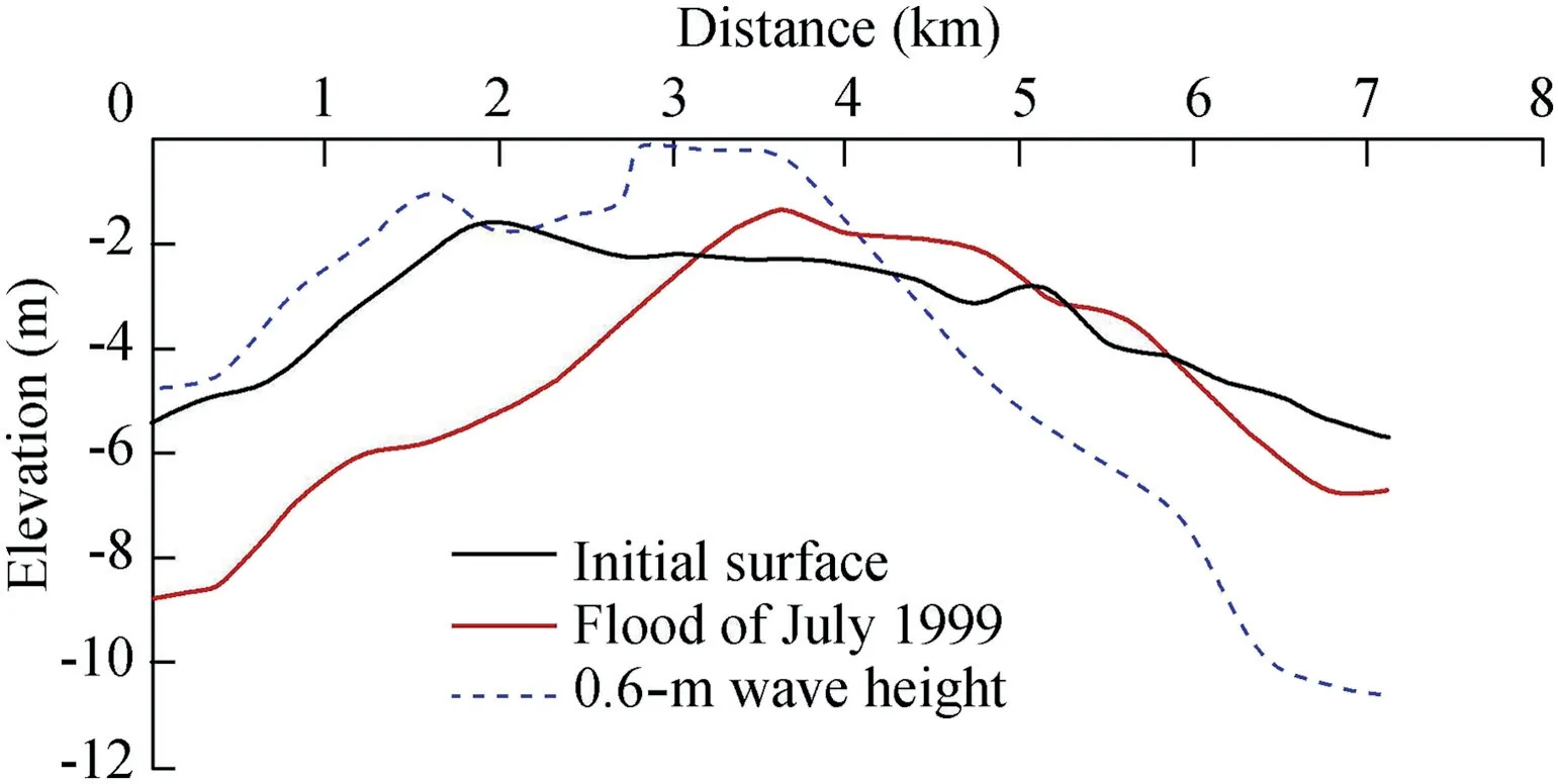
Fig. 5. Longitudinal profiles of mouth bar under impacts of different hydrodynamic factors.
A flume model for the longitudinal profile of the mouth bar in the Modaomen Estuary was used to simulate the morphological evolution of the mouth bar,subject to different hydrodynamic factors. According to the hydrodynamic characteristics of the study area, two tests, the impact only of floods and the interaction of floods and waves,were conducted in the flume experiment.
4.1. Evolution of mouth bar under impact of floods
In this test, floods with different return periods lasting for 80 min (equivalent to five days of the in situ flood) were chosen. The longitudinal profiles of the mouth bar are shown in Fig. 6 and the parameters of morphological changes are displayed in Table 1.
Under the impacts of floods with different return periods,the sediment on the inner slope was active.The crest and outer slope of the mouth bar were relatively weak regions of sediment motion, as in previous experimental results.
According to the numerical model of the Modaomen Estuary by He et al. (2018), the inner slope of the mouth bar tended to be eroded, which is consistent with the variations of the profile in the present flume experiment. As shown in Table 1,scouring was more apparent on the inner slope and at the crest of the mouth bar,and the scour depth increased with the intensity of floods. The average scour depths of the inner slope were 0.4 m and 1.1 m under the impacts of the flood of July 1999 and the flood with a five-year return period, while the values were close to 2 m under the impacts of the floods with 20-and 50-year return periods and the flood of July 2005.Under the same conditions, the scour depths at the crest were 0.6 m, 1.1 m, and 1.6-1.7 m, respectively.
Generally, the impact of floods is highly intertwined with mouth bar evolution in estuarine regions (Wu et al., 2018).He et al. (2018) showed that flood events led to the consistently seaward movement of the mouth bar in the Modaomen Estuary, especially the bar apex's displacement.The experimental results show that the bar crest moved 800 m and 1200 m seawards under the influences of the flood of July 1999 and the flood with a five-year return period.Additionally, the bar crest moved more than 1300 m under the influences of the flood of June 2005 and the floods with 20- and 50-year return periods, indicating a positive correlation between the moving distance of the bar crest and the flood intensity.Although the slope and crest were eroded,the riverbed was silted up and raised due to the sediment transport downstream being subject to weaker hydrodynamic forces, leading to the formation of a new crest of the mouth bar. However, little bathymetric change was found at the mouth bar crest.The test results show that the peak height of the initial surface was -1.6 m, while the peak height of the new crest was in the range of -1.5 to -1.8 m under the impacts of floods at different intensities.

Fig. 6. Longitudinal profiles of mouth bar subject to floods of different frequencies.
4.2.Evolution of mouth bar under flood-wave interaction
Understanding sediment transport driven by waves that interact with the discharge of fluvial sediment is crucial to analysis of the morphological evolution of the mouth bar.Therefore, modeling of the combined effect of floods and waves was conducted in this study. The wave used in this study was the normal wave in summer in the Modaomen Estuary, and the wave height was 0.6 m at the outer slope.The results of the combined action of the two factors are shown in Fig. 7. The bed parameters of morphological changes are displayed in Table 2.
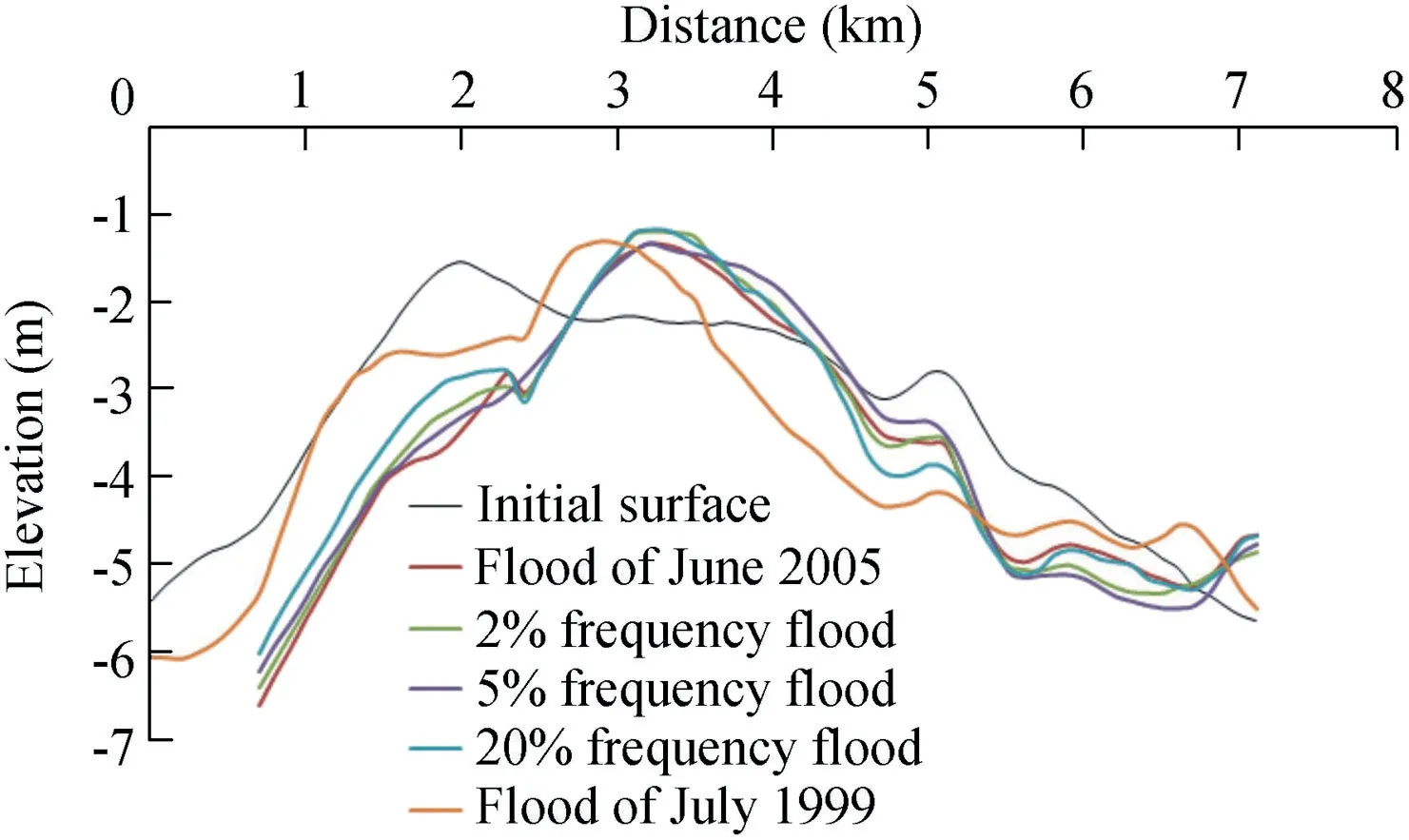
Fig. 7. Longitudinal profiles of mouth bar under flood-wave interaction.
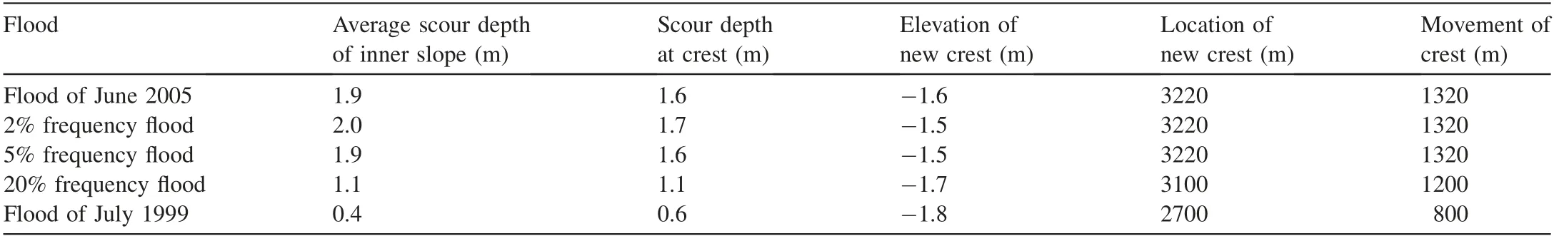
Table 1Changing bed parameters of mouth bar under effect of floods.
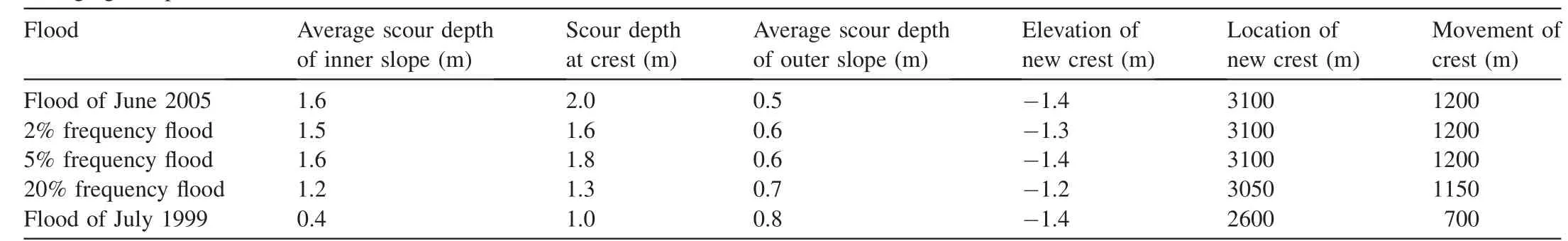
Table 2Changing bed parameters of mouth bar under flood-wave interaction.
Wind waves also play a significant role during the mouth bar evolution.The waves attacking the river mouth bar appear to lift the sediment. Based on the ideal model developed with Delft 3D, Nardin et al. (2013b) found that large waves hindered the formation of the mouth bar, especially for waves with an incoming angle of 45°-60°.In this study,it was found that the flood-wave interaction had a more significant impact on the mouth bar evolution than floods only.
The inner slope showed tiny ripples, and the crest and the outer slope were smoother in the flume experiment. The inner slope and crest of the mouth bar were both significantly scoured. The depth of erosion increased with the intensity of floods,as shown in Table 2.With consideration of wave impact,the scouring effect on the outer slope was more significant,leading to scour depths of 0.5-0.8 m on average.However,the scour depth of the inner slope was slightly less than it was without consideration of the wave impact,since the interaction between waves and floods offset the effect of the flood-induced erosion in the river channel as waves crossed over the crest.
As a result of the combined hydrodynamic effect of floods and waves, the bar crest also moved seawards, for a distance shorter than that under only the impact of floods. The difference was about 100 m because of the backwater effect of waves. The results also show that the height of the mouth bar crest was enhanced. The peak height of the initial topography was -1.6 m, while the peak height of the new crest was between-1.2 m and-1.4 m under the interaction of waves and floods with five different frequencies. Subsequently, the deposited sediment moved to the position of the dynamic equilibrium point.Therefore,in this case,the wave energy not only had a backwater effect on runoff,but also provided a new sediment resource.
5. Conclusions
Mouth bar formation is a complex process, owing to the interactions of multiple hydrodynamic processes.Based on the flume experiment in this study,the evolution of the mouth bar in the Modaomen Estuary was modeled under different hydrodynamic conditions.The effects of floods and waves on the longitudinal profile evolution of the mouth bar were analyzed using a flume model.The present work focused on two cases:the evolution of the river mouth bar under only the flood impact and the interaction of waves and floods.
In the case of floods only,the sediment motion on the inner slope of the mouth bar was substantial. The sediment moved outwards in the form of suspended load and bed load. The sediment motion on the outer slope and the lower reach of the crest was found to be relatively weak. Furthermore, sand ripples appeared on the riverbed.The inner slope and the crest of the mouth bar experienced significant erosion. The scour depth had a potential to increase with the intensity of floods.Moreover,the crest of the mouth bar moved seawards,with the displacement increasing with the intensity of floods.However,the elevation of the crest was found to remain relatively stable.For the case of the interaction of floods and waves,the sediment movement on the inner slope was similar to what it was in the former case.At the crest of the mouth bar,the feature of lifting sand via waves and transporting sand via currents resulted in the seaward migration of sediment. Tiny ripples appeared on the inner slope, while the crest and outer slope were found to be smoother.The results of the interaction of floods and waves show that the inner and outer slopes suffered scouring.The evolution of theinnerslopeandthe positionofthe crestweresimilartothosein the former case.However,the sediment movement was weaker and the crest of the mouth bar experienced more sediment aggradation than in the former case.
 Water Science and Engineering2019年2期
- Water Science and Engineering的其它文章
- Porosity and permeability variations of a dam curtain during dissolution
- Numerical simulation of flow separation over a backward-facing step with high Reynolds number
- Possibilities and challenges of expanding dimensions of waterway downstream of Three Gorges Dam
- River bank protection from ship-induced waves and river flow
- Submerged flexible vegetation impact on open channel flow velocity distribution: An analytical modelling study on drag and friction
- Correlations between silt density index, turbidity and oxidation-reduction potential parameters in seawater reverse osmosis desalination