基于決策樹模型的文山三七種植面積估算方法研究
2017-12-15 11:16:25史婷婷張小波郭蘭萍黃璐琦
中國中藥雜志 2017年22期
史婷婷 張小波 郭蘭萍 黃璐琦
[摘要]通過研究基于遙感的中藥材種植面積提取方法,實現中藥材種植面積消長趨勢的動態監測,可為中藥資源保護和利用提供決策支持。該文以云南省文山州三七種植為例,以國產“高分一號”(GF1)16 m的多光譜遙感影像為數據源,選取能夠最大程度反映文山三七棚和背景地物波譜差異的時相,根據地物的波譜特征構建決策樹模型實現文山三七種植面積的提取。結果表明:基于決策樹模型的遙感分類方法可以有效地提取出研究區內的三七種植地塊并估算出種植面積,該方法可為三七種植面積提取提供技術支撐。
[關鍵詞]GF1; 文山三七; 決策樹; 種植面積; 波譜特征
[Abstract]The herbs used as the material for traditional Chinese medicine are always planted in the mountainous area where the natural environment is suitable As the mountain terrain is complex and the distribution of planting plots is scattered, the traditional survey method is difficult to obtain accurate planting areaIt is of great significance to provide decision support for the conservation and utilization of traditional Chinese medicine resources by studying the method of extraction of Chinese herbal medicine planting area based on remote sensing and realizing the dynamic monitoring and reserve estimation of Chinese herbal medicines In this paper, taking the Panax notoginseng plots in Wenshan prefecture of Yunnan province as an example, the Chinamade GF1multispectral remote sensing images with a 16 m×16 m resolution were obtained Then, the time series that can reflect the difference of spectrum of P notoginseng shed and the background objects were selected to the maximum extent, and the decision tree model of extraction the of P notoginseng plots was constructed according to the spectral characteristics of the surface features The results showed that the remote sensing classification method based on the decision tree model could extract P notoginseng plots in the study areaeffectively The method can provide technical support for extraction of P notoginseng plots at county level
[Key words]GF1; Panax notoginseng; decision tree; planting area estimation; spectral features
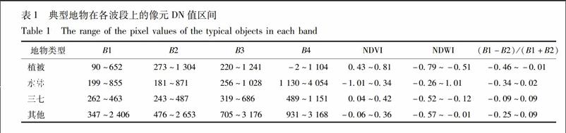
三七Panax notoginseng (Burk) FH Chen,為五加科人參屬,多年生草本植物。其藥用歷史悠久,是我國名貴中草藥,曾享有“金不換”、“南國神草”之美譽,是我國大宗出口藥材之一。三七適宜生長在冬暖夏涼和半陰、潮濕的環境中,主要分布在我國西南部、越南北部以及鄰近的一些地區[1]。我國云南文山州作為其原產地和主產區,種植面積和產量均占全國的90%以上[2],是我國的“三七之鄉”。因此,準確掌握云南文山州的三七種植面積和空間分布情況,對于國家相關部門監管三七種植、制定三七產業政策具有重要指導意義。
遙感技術以其快讀、方便、經濟等特點,在農林牧業等領域的資源調查和監測方面已經進行了大范圍的應用,并顯示出了極大的優勢,為中藥資源調查、儲量估算和動態監測提供了理論基礎[36]。
遙感技術通過觀測地表反射或地物自身輻射的電磁波信號,從而進行分析、判讀地表的目標和多種地學現象。該技術獲取信息受條件限制較少,可獲取大范圍的影像資料,為大范圍的三七種植情況監測提供了有效、可行的方法。
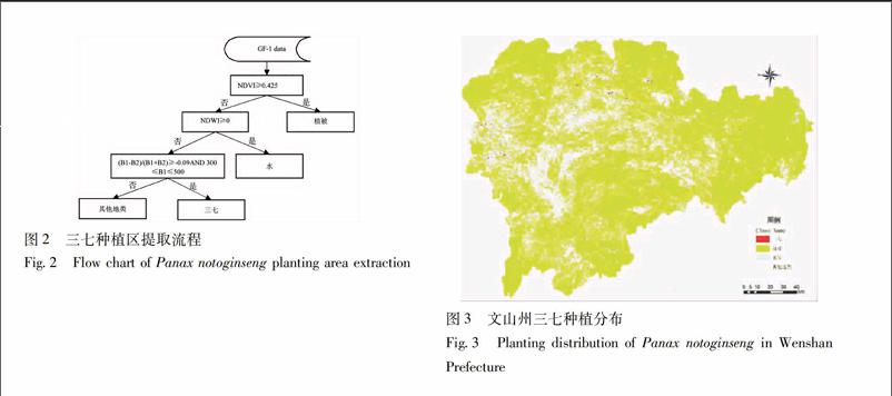
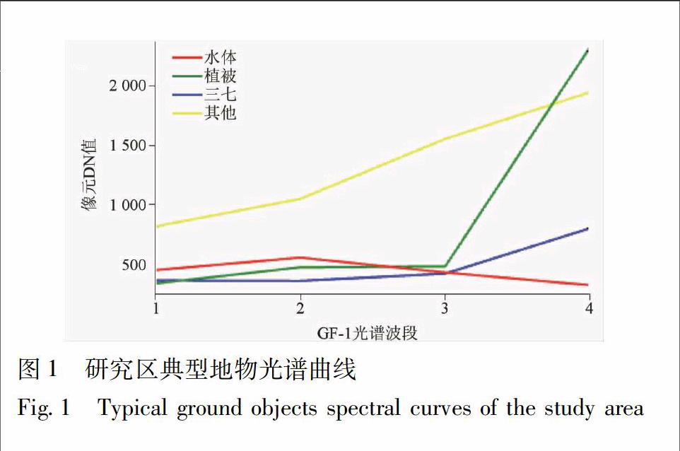
本文以云南省文山州的三七種植地為研究對象,基于遙感技術為支持,以國產高分一號影像為數據源,利用決策樹分類法提取云南省文山州三七種植面積,為中藥材種植面積的準確獲取提供方法參考。
1材料與方法
11研究區概況文山州位于云南省東南部,地跨東經103°35′—106°12′,北緯22°40′—24°48′。地處滇東南喀斯特山原,地勢西北高東南低,山區和半山區占總土地面積的97%,平均海拔在1 000~1 800 m。全州均屬低緯度高原季風氣候。干濕季分明,5—10月為雨季,雨量占全年雨量的82%;11月至次年4月為干季,雨量占年雨量的18%。年均降水量779 mm。文山州大部分地區冬無嚴寒,夏無酷暑,最冷月(1月)平均溫度65~135 ℃,最熱月(7月)平均溫度170~285 ℃,年均氣溫19 ℃。
