甘肅岷縣漳縣6.6級地震前后區(qū)域地殼形變分析①
2016-01-18 05:22:34朱爽,周偉
地震工程學報 2015年3期
甘肅岷縣漳縣6.6級地震前后區(qū)域地殼形變分析①
朱爽, 周偉
(中國地震局第一監(jiān)測中心,天津 300180)
摘要:利用陸態(tài)網GNSS連續(xù)站及流動站觀測數據處理結果,從坐標時間序列、基線時間序列、速度場、形變場等方面分析岷縣漳縣地震前后青藏高原東北緣地區(qū)GPS形變場變化,得出以下結論:岷縣漳縣地震前GNSS測站時間序列沒有明顯變化,震前異常不突出;地震引起不同測點不同程度的永久性同震位移,最大值達到16 mm;地震前后基線變化不明顯,未發(fā)現明顯的前兆異常;阿拉善及附近的祁連構造帶存在順時針運動的跡象,即運動方向由東側的南西向逐漸變到西部的北西向,運動大小的范圍基本保持在7 mm/a之內;區(qū)域主壓應變優(yōu)勢方向為東北-西南向,最大主壓應變區(qū)呈帶狀分布于研究區(qū)域南部。
關鍵詞:岷縣漳縣地震; GNSS; 時間序列; 速度場; 應變場
收稿日期:①2014-07-01
基金項目:地震科技星火計劃(XH15061Y);地震行業(yè)科研專項(201308009);震情跟蹤青年課題(2015010205)
作者簡介:朱爽(1987-),女(漢族),助理工程師,主要從事GNSS數據處理與分析研究。E-mail:shzhu1026@163.com。
中圖分類號:P315.72文獻標志碼:A
DOI:10.3969/j.issn.1000-0844.2015.03.0731
Regional Crustal Deformation Analysis before and
after the Minxian-Zhangxian Earthquake
ZHU Shuang, ZHOU Wei
(FirstCrustMonitoringandApplicationCenter,CEA,Tianjin300180,China)
Abstract:With the establishment of the Crustal Movement Observation Network of China (CMONOC) and the China Tectonic Environment Monitoring Network (CMTEMN),earthquake coseismic displacement can be obtained through global navigation satellite system (GNSS) data processing and analysis.The calculated results can provide basic research data for further study on seismic dynamics characteristics and determination of future earthquake trends.Using the GNSS data processing results from CMTEMN and CMONOC,together with the coordinate time series from the continuous observation stations,the baseline time series between two stations and the velocity and deformation fields were investigated in this study.In addition,the global positioning system deformation field of the northeastern margin of the Qinghai-Tibet plateau before and after the Minxian-Zhangxian Earthquake was analyzed.The results showed that the coordinate time series of the GNSS stations showed no noticeable change before the Minxian-Zhangxian Earthquake,and there were no prominent anomalies before the earthquake.The earthquake caused different levels of permanent co-seismic displacement of various stations,the maximum of which was as much as 16 mm This GSMX station,which is near the epicenter in the Lintan-Dangchang fault,exhibited a noticeable coseismic displacement.The GSWD station had no coseismic displacement.Similarly, the GSLX station,which was far from the epicenter,also experienced no displacement.The strain change of the three stations proved that the east-west strain was primarily linear,and there was no noticeable imminent anomaly before the earthquake removal of the coseismic step.The north-south strain exhibited a cycle and a half phenomenon,which was related to a corresponding year cycle in a single point,so this was not an obvious imminent anomaly prior to the earthquake.In addition to the obvious linear change,the north-east shear strain showed specific cycles,but no obvious anomalies before the quake,and these were restored to their original displacement after the quake.The GNSS baseline length change was based on the unity of the reference frame,so it was unaffected by the reference benchmark,therefore,it would objectively reflect the dynamic changes of the relative motion between two stations.Therefore,the GNSS baseline time series analysis was used to extract the crust movement microdynamic information as one of the direct routes.In this study,three stations close to the epicenter formed a triangular mesh,crossing the epicenter and the Lintan-Dangchang fault zone.Using the GSWD station as a reference, the statistical baseline series of the GSMX and GSLX stations were analyzed,and the results showed that there was no significant change of the baseline before and after the earthquake and no obvious anomalies;In addition,the long baseline time series across the Lintan-Dangchang fault was calculated employing six stations on either side of the seismogenic tectonic,forming five baselines.The results were same with the short baseline,before the earthquake,the baseline did not exhibit an obvious precursory change phenomenon,and the baseline change caused by the earthquake was not obvious in totality.There were signs of a clockwise motion near the Alashan and Qilian structural belt,where the direction of movement was south west on the east side and north west on the west side.The magnitude of the movement was within 7,which may explain why the push movement to the north in the western region was greater in the eastern area.In addition,due to the extrusion of the Ordos block in the east of the research area,the direction of movement of the edge of the block at the southeastern end in this region was to the southwest and its velocity was approximately 5 mm/a,The movement of the block was diminished in the western portion.The primary direction of the principal compressive strain from 2011 to 2013 was from the SE to NW,the region of maximum strain exhibited zonal distribution and was located in the southern part of the research area.
Key words: the Minxian-Zhangxian Earthquake; GNSS(global navigation satellite system); time series analysis; velocity field; strain field
0引言
2013年7月22日甘肅岷縣漳縣交界(E104.2°,N34.5°)發(fā)生了MS6.6地震。地震所處的青藏高原東北緣是印度與歐亞兩大板塊碰撞作用由近南北方向向北東、東方向轉換的重要場所,是物質東流的匯聚之處[1-2]。青藏高原東北緣大型構造邊界地帶以地震活動和構造運動之強烈和減災意義之重要而倍受關注[3]。很多學者利用GNSS資料分析了青藏高原東北緣的構造變化[4-9]。岷縣漳縣地震后,王雙緒等[10]利用震區(qū)所在的青藏塊體東北緣地區(qū)的區(qū)域水準、GPS、流動重力和跨斷層短測線等地形變監(jiān)測資料,結合地質構造、動力環(huán)境和已往的研究成果,分析了不同類型資料反映的震前區(qū)域性地殼變形背景、斷層形變異常特征和可能的機理。李桂榮等[11]分析了震中附近“陸態(tài)網絡”基準站GPS數據,發(fā)現大多數基準站位移三分量時間序列曲線出現突變性異常。
本文利用陸態(tài)網GNSS連續(xù)站和流動站觀測資料,利用GAMIT及QOCA軟件計算時間序列、速度場,并依據多核函數等新方法[12-16]提取其應變場信息,進而分析岷縣漳縣地震前后青藏高原東北緣地區(qū)地殼形變。
1GNSS數據處理
首先,收集陸態(tài)網2010年至2014年年積日346日連續(xù)站觀測數據,2011、2013年陸態(tài)網流動觀測數據,結合中國周邊77個IGS站的相應數據,統(tǒng)一利用GAMIT/GLOBK軟件進行GNSS解算,得到測站坐標及衛(wèi)星軌道的單日松弛解。解算策略如下:截止衛(wèi)星高度角為15°;基線處理模式為RELAX(松馳解);衛(wèi)星鐘差模型為精密星歷誤差的鐘差參數;接收機鐘差改正模型為偽距計算出的鐘差;電離層延遲模型為LC-HELP;對流層模型為Saastamoinen模型;光壓模型為BERNE;固體潮改正為IERS03;測站坐標約束為0.010 m,0.010 m,0.010 m ;對流層參數設置為13。然后利用QOCA軟件對上述多個單日松弛解結果進行融合,選取分布于全球的47個GPS測站作為框架點,經過平差計算得到ITRF2005框架下的速度場。最后通過基準變換將觀測結果轉換為區(qū)域無旋轉下的速度場。在解算過程中為減小2011年3月11日日本9.0級地震影響,首先利用GPS連續(xù)觀測數據計算得到該地震引起的遠場同震位移,然后利用該結果對速度求解過程中的同震影響進行扣除。在此基礎之上,利用多核函數法得到該區(qū)域的應變場信息。
2坐標時間序列分析
在震中附近有三個GNSS連續(xù)觀測站,其中一個是位于震中西南約18 km處的GSMX(甘肅岷縣)站,另一個是位于震中東北約68 km處的GSLX(甘肅隴西)站,此外還有一個位于震中東南約132 km處的GSWD(甘肅武都)站,見圖1。
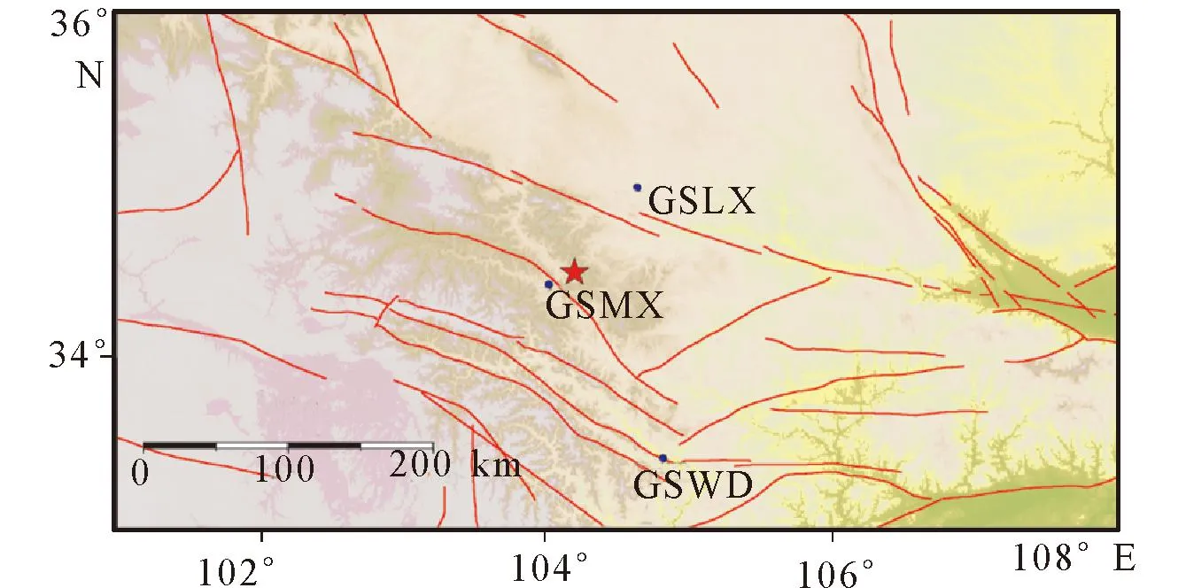
圖1 點位分布圖(圓點表示連續(xù)站,五角表示地震震中) Fig.1 Distribution of the stations (dot indicates continuous station,pentagon indicates earthquake's epicentre)

圖2 三個測站時間序列變化 Fig.2 Time series variation of three stations
本文分析這三個測站在N、E、U三個方向上的坐標時間序列(圖2)。可以看出,從長趨勢來看,三個測站在E方向上的線性較好,變化穩(wěn)定,在N方向上的變化具有一定的周期性,而在U方向上則有明顯的年周期特征;從短趨勢來看,只有距震中最近的GSMX站出現了16 mm左右的永久同震位移,而且僅在水平方向上;其余兩個測站不僅在震前沒有出現明顯的異常變化,在震時也沒有出現同震位移。說明該次地震的同震位移不僅量級較小,而且集中在較小的空間范圍之內。因此從單個測站的坐標時間序列中很難發(fā)現震前的異常情況。
岷縣漳縣地震后,國內外多家機構給出了地震的震源機制解結果(表1),顯示地震主要以逆沖為主,兼具左旋走滑性質。鄭文俊[17-18],許沖[19]等的文章也證實了該結論與調查結果基本一致,同時證實地震破裂的走向與臨潭—宕昌斷裂的走向一致。結合震中周邊連續(xù)站的同震位移可以看出,離震中較近,在臨潭—宕昌斷裂上的GSMX站有較明顯的同震位移,與地震破裂方面相反的GSWD沒有同震位移,同樣,距離較遠的GSLX站也沒有明顯的同震位移,這與地震沿臨潭-宕昌斷裂走向破裂的結論相一致。
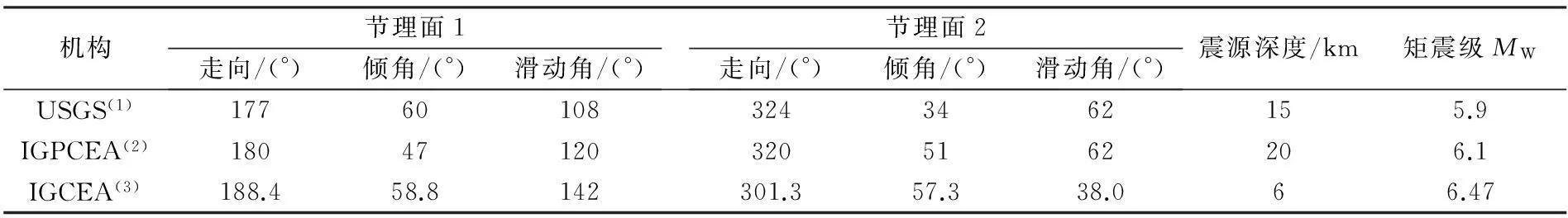
表 1 地震震源機制解結果
注:(1)USGS NEIC(http://www.isc.ac.uk/iscbulletin/search/catalogue)
(2) 中國地震局地球物理研究所(IGPCEA, http://www.cea_igp.ac.cn/tpxw/267408.sthtml)
(3) 中國地震局地質研究所(IGCEA, http://www.eq_igl.ac.cn/admin/upload/files/20130722Dingxi.Pdf)
利用GSMX、GSLX、GSWD這三個站的時間序列,計算由這三個測站圍成的區(qū)域應變變化(圖3)。可以看出,東西向應變主要表現出明顯的線性,除去同震引起的階躍,在震前未發(fā)現明顯的臨震異常;南北向應變具有明顯的年周期與半年周期現象,這與單點時間序列在北方向上存在年周期相對應,在震前也幾乎看不到臨震異常;從北東向剪切來看,除了存在明顯的線性變化外,還存在著一定的周期變化,在震前沒有出現明顯異常,震后也恢復了原來的變化。
3基線時間序列分析
由于基于統(tǒng)一參考框架的GNSS基線長度變化基本不受參考基準的影響,能夠較客觀地直接反映兩站之間的相對運動的動態(tài)變化,所以GNSS基線時間序列分析是提取地殼運動微動態(tài)信息較直接的途徑之一[20]。本文中距離震中較近的三個測站組成了一個包含震中在內的三角網,并且該網跨越了臨潭—宕昌斷裂帶。以GSWD站為參考,統(tǒng)計了GSMX、GSLX兩個測站與其分別形成的基線,試圖從基線長度的變化來分析震前是否有明顯的異常(圖4)。
從圖4可以看出,兩條基線長度的變化具有明顯的周期性,呈現出夏天變長,冬天變短的季節(jié)更替;但在地震前沒有出現明顯的異常,即從基線長度的變化看不出明顯的前兆信息;地震后也沒有出現明顯的異常變化,可見岷縣漳縣地震并沒有引起斷層的明顯活動。

圖3 應變時間序列 Fig.3 Strain time series
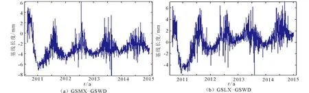
圖4 基線時間序列變化 Fig.4 Time series variation of baseline
另外,本文以GSWD站為參考,統(tǒng)計GSMX、GSLX兩個測站相對于GSWD站的兩條基線在N、E、U三個方向上的變化,從測站相對位置變化的角度分析震前震后的變化(圖5)。

圖5 GSMX、GSLX相對于GSWD坐標在N、E、U方向上的變化 Fig.5 Coordinate change of GSMX、GSLX relative to GSWD in N、E、U directions
由圖5可以看出,GSMX站相對于GSWD站這條基線在三方向上的變化不突出,比較明顯的是地震引起的同震導致E、N方向上的抬升,在震前及震后沒有明顯的異常;而GSLX-GSWD站則沒有明顯的變化,符合變化周期運動。這個結果也驗證了上面基線長度沒有發(fā)生明顯變化這一結果,說明地震前后該地區(qū)斷層沒有出現明顯的異常活動。
此外,本文計算了跨越臨潭-宕昌斷裂帶的長基線時間序列,選擇發(fā)震構造兩側的若干臺站進行分析,一共計算了5條基線(圖6)。

圖6 長基線分布圖 Fig.6 Distribution of long baseline
其中, GSLX(甘肅隴西)—GSMA(甘肅瑪曲),GSLX(甘肅隴西)—GSMX(甘肅岷縣),GSDX(甘肅定西)—GSMA(甘肅瑪曲)三條基線是成穩(wěn)定的擠壓狀態(tài),GSLX(甘肅隴西)—SCSP(四川松潘),GSDX(甘肅定西)—GSWD(甘肅武都)成穩(wěn)定的拉張狀態(tài),具體如圖7所示。GSLX—GSMX由于GSMX站的同震位移引起了階躍;GSLX—SCSP基線在震后的變化是由于SCSP測站時間序列的變化;結合其它基線變化情況可以看出在震前基線沒有明顯的前兆變化,地震引起的基線變化整體來看并不明顯。
4速度場及應變場分析
本文收集了2011、2013年兩期陸態(tài)網流動觀測數據,結合兩年的連續(xù)站觀測數據進行解算。在GAMIT得到單日松弛解的基礎之上,利用QOCA軟件計算去除了3月11日本大震影響的2011—2013年速度場,并利用多核函數法計算應變場信息(圖8)。
圖8(a)為青藏高原東北緣相對于區(qū)域整體無旋轉基準的區(qū)域水平運動結果。從圖中可以看出,該區(qū)北部(阿拉善及附近的祁連構造帶)存在順時針運動的跡象,即運動方向由東側的SW向逐漸變到S部的北西向,運動大小的范圍基本保持在7 mm/a之內,這可能說明了研究區(qū)西部向北的推擠較東部更大。另外,該區(qū)東部由于受到鄂爾多斯塊體的擠壓,東南部西端由北北東向運動隨著向東南地域的縱深其方向也有序的變化,到該區(qū)的東南端其優(yōu)勢運動方向已指向西南;運動大小也發(fā)生了變化,東端約5 mm/a,向西逐漸變小。這與2009—2011年的水平運動場相比[20],東北方向出現了一些明顯的變化,但距離地震較近的地方發(fā)生只在量值上發(fā)生了較小變化,這可能與岷縣漳縣地震的發(fā)生背景有關。研究區(qū)西南地域的運動形態(tài)呈扇形展布,這種展布與物質逐漸向西北和東南兩方向的運移是相輔相成的,而且西南端運動較大,可能與玉樹地震的震后調整有關。

圖7 長基線時間序列圖 Fig.7 Time series of long baseline
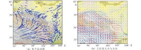
圖8 青藏高原東北緣地區(qū)2011—2013年水平運動場及主應變大小與方向 Fig.8 Horizontal movement field,principal strain and its orientaion in northeastern margin of the Qinghai-Tibetan plateau from 2011 to 2013
圖8(b)為以應變張量形式展現主應變方向和大小的空間分布狀態(tài)。該圖表明區(qū)域主壓應變優(yōu)勢方向為東北—西南向,在空間上雖有變化,但有序性較好。從宏觀上看,自西向東主壓應變的方向為西部的東北—西南向變到東部的近東西向,與早期的結果發(fā)生了一些變化[21-22]。雖然主應變方向上有一定的繼承性,但大小發(fā)生了一些明顯的變化,這與玉樹地震的發(fā)生有一定的關系。就整體數值大小而言,南部的巴彥喀拉塊體形變最大,隨著向北的延伸而逐漸減弱,跨過祁連構造帶則接近于零,說明研究區(qū)的形變具有明顯的分區(qū)特征。
5結論
岷縣漳縣地震前GNSS單站時間序列沒有明顯變化,震前異常不突出;地震引起不同測點不同程度的永久性同震位移,最大值達到16 mm;地震前后基線變化不明顯,未發(fā)現明顯的前兆異常;青藏高原東北緣地區(qū)2011—2013年水平運動清晰有序,相對于2009—2011年的變化較小,地震并未引起運動場的明顯變化,區(qū)域主壓應變優(yōu)勢方向為東北—西南向,最大主壓應變區(qū)呈帶狀分布于研究區(qū)域南部。GNSS測站的坐標變化情況還不能為地震提供明顯的前兆信息,但從運動場的信息可以看出地震還是引起了運動場的一些變化,有待進一步研究。
參考文獻(References)
[1] 嘉世旭,張先康.青藏高原東北緣深地震測深震相研究與地殼細結構[J].地球物理學報,2008,51(5):1431-1443.
Jia S X,Zhang X K.Study on the Crust Phases of Deep Seismic Sounding Experiments and Fine Crust Structures in the Northeast Margin of Tibetan plateau[J].Chinese J Geophys,2008,51(5):1431-1443.(in Chinese)
[2] 張國偉,郭安林,姚安平.中國大陸構造中的西秦嶺—松潘大陸構造結[J].地學前緣,2004,11(3):23-32.
ZHANG Guo-wei,GUO An-lin,YANG An-ping.Western Qinling-Songpan Continental Tectonic Node in China’s Continental Tectonic[J].Earth Science Frontiers,2004,11(3):23-32.(in Chinese)
[3] 王雙緒,張希,張四新,等.青藏高原東北緣現今構造變動與地震活動特征[J].地球學報,2005,26(3):209-216.
WANG Shuang-xu,ZHANG Xi,ZHANG Si-xin,et al.Characteristics of Recent Tectonic Deformation and Seismic Activity in the Northeastern Margin of Tibetan Plateau[J].Acta Geoscientica Sinica,2005,26(3):209-216.(in Chinese)
[4] 崔篤信,王慶良,王文萍.昆侖8. 1級地震對青藏高原東北緣地殼形變場的影響[J].大地測量與地球動力學,2008,28(3):1-8.
CUI Du-xin,WANG Qing-liang,WANG Wen-ping,et al.Effect of KunlunMS8.1 Earthquake on Crustal Deformation in Northeastern Margin of Qinghai-Tibet Plateau[J].Journal of Geodesy and Geomatics,2008,28(3):1-8.(in Chinese)
[5] 楊國華,江在森,張風霜,等.昆侖山8.1級地震對青藏高原東北緣地殼水平形變影響的討論[J].國際地震動態(tài),2007(7):53-60.
YANG Guo-hua,JIANG Zai-sen,ZHANG Feng-shuang,et al.The Effect of Kunlun Mountain inMS8.1 Earthquake to Horizontal Crustal Deformation on the Northeastern Edge of Qinghai-Tibet Block [J].Recent Developments in World Seismology,2007(7):53-60.(in Chinese)
[6] 李金平.青藏高原東北緣地殼形變GPS 監(jiān)測網的建立和精度分析[J].測繪通報,2006,5:11-13.
LI Jin-ping.Establishment and Precision Analysis of Crust Deformation GPS Monitoring Network in Northeastern Margin of the Qinghai-Tibetan Plateau[J].Bulletin of Surveying and Mapping,2006(5):11-13.(in Chinese)
[7] 甘衛(wèi)軍,程朋根,周德敏.青藏高原東北緣主要活動斷裂帶GPS加密觀測及結果分析[J].地震地質,2005,27(2):177-187.
GAN Wei-jun,CHENG Peng-gen,ZHOU De-min.Observation of A GPS Profile Across Main Faults on Northeast Margin of Tibetan Plateau and Data Analysis[J].Seismology and Geology,2005,27(2):177-187.(in Chinese)
[8] 李強,江在森,武艷強.汶川地震震后短期青藏高原東北緣地殼變形特征成因討論[J].地震,2013,33(3):124-132.
LI Qiang,JIANG Zai-sen,WU Yan-qiang,et al.Discussion on the Implications of Short-term Crust Deformation Characteristics in the Northeastern Margin of Tibetan Plateau after the 2008 Wenchuan Earthquake[J].Earthquake,2013,33(3):124-132.(in Chinese)
[9] 張永志,胡斌,陳宏賓.應用GPS 觀測青藏高原東北緣應力場變化[J].長安大學學報:地球科學版,2003,25(4):80-84.
ZHANG Yong-zhi,Hu Bin,Chen Hongbin.Variation of Stress Computed From GPS Measurement in Northeastern Margin of Qinghai—Tibet Plateau China[J].Journal of Chang’an University:Earth Science Edition,2003,25(4):80-84.(in Chinese)
[10] 王雙緒,蔣鋒云,李寧,等.岷縣漳縣6.6級地震前區(qū)域地殼運動變形背景與斷層形變異常特征[J].地震工程學報,2013,35(3):503-512.
WANG Shuang-xu,JIANG Feng-yun,LI Ning,et al.Regional Crustal Movement Background and Cross-fault Deformation Anomaly Characteristics Prior to the Minxian-ZhangxianMS6.6 Earthquake[J].China Earthquake Engineering Journal,2013,35(3):503-512.(in Chinese)
[11] 李桂榮,艾力夏提·玉山,王曉強,等.甘肅岷縣漳縣MS6.6地震前“陸態(tài)網絡”基準站東西分量時序曲線異常特征研究[J].地震工程學報,2013,35(3):542-548.
LI Gui-rong,Ailixiaxti Yushan,WANG Xian-qiang,et al.Study on Abnormal Features in EW Displacement before Minxian-ZhangxianMS6.0 Earthquake in Gansu[J].China Earthquake Engineering Journal,2013,35(3):542-548.(in Chinese)
[12] 楊博,張風霜,韓月萍.球面水平應變場無偏差計算與濾波[J].地震研究,2011,34(1):59-66.
YANG Bo,ZHANG Feng-shuang,HAN Yue-ping.Non-deviation Calculation and Filtering of Spherical Horizontal Stain Field[J].Journal of Seismological Research,2011,34(1):59-66.(in Chinese)
[13] 楊國華,楊博,武艷強,等.應變計算與分析的若干問題及有關偏差的修正[J].大地測量與地球動力學,2010,30(4):59-63.
YANG Guo-hua,YANG Bo,WU Yan-qiang,et al.Several Problems of Strain Calculation and Analysis and Correction of Related Deviation[J].Journal of Geodesy and Geodynamics,2010,30(4):59-63.(in Chinese)
[14] 楊博,張風霜,占偉,等.水平運動場濾波的嘗試及其應變計算[J].大地測量與地球動力學,2010,30(5):106-112.
YANG Bo,ZHANG Feng-shuang,ZHAN Wei,et al.Experiment for Filtering Horizontal Movement Field and Its stain Calculation[J].Journal of Geodesy and Geodynamics,2010,30(5):106-112.(in Chinese)
[15] 楊國華,江在森,武艷強,等.中國大陸整體無凈旋轉基準及其應用[J].大地測量與地球動力學,2005,29(4):6-10.
YANG Guo-hua,JIANG Zai-sen,WU Yan-qiang,et al.No-net-ratation on Crustal Movement of China mainlind and its application[J].Journal of Geodesy and Geodynamics,2005,29(4):6-10.(in Chinese)
[16] 楊國華,韓月萍,楊博.川滇地區(qū)地殼水平運動與變形場的演化特征及其機制討論[J].地震研究,2009,32(3):275-282.
YANG Guo-hua,HAN Yue-ping,YANG Bo.Discussion about the Evolvement Characteristics and the Mechanism of the Crustal Horizontal Movement and Deformation Field in Sichuan—Yunnan Area[J].ournal of Seismological Research,2009,32(3):275-282.(in Chinese)
[17] 鄭文俊,閔偉,何文貴,等. 2013年甘肅岷縣漳縣6.6級地震震害分布特征及發(fā)震構造分析[J].地震地質,2013,35(3):604-615.
ZHENG Wen-jun,MIN Wei,HE Wen-gui,et al.Distribution of the Related Disaster and the Causative Tectonic of the Minxian-ZhangxianMS6.6 Earthquake on July 22,2013,Gansu,China[J].Seismology and Geology,2013,35(3):604-615.(in Chinese)
[18] 鄭文俊,袁道陽,何文貴,等.甘肅東南地區(qū)構造活動與2013年岷縣—漳縣MS6.6級地震孕震機制[J].地球物理學報,2013,56(12):4058-4071.
ZHENG Wen-jun,YUAN Dao-yang,HE Wen-gui,et al.Geometric Pattern and Active Tectonics in Southeastern Gansu Province:Discssion on Seismogenic Mechanism of the Min-xian—ZhangxianMS6.6 Earthquake on July 22,2013[J].Chinese J Geophys[J].2013,56(12):4058-4071.(in Chinese)
[19] 許沖,徐錫偉,鄭文俊,等.2013年甘肅岷縣漳縣6.6級地震觸發(fā)滑坡及其構造分析[J].地震地質,2013,35(3):616-626.
XU Chong,XU Xi-wei,ZHENG Wen-jun,et al.Landslides Triggered by the 2013 Minxian—Zhangxian,Gansu ProvinceMS6.6 Earthquake and its Tectonic Analyses[J].Seismology and Geology,2013,35(3):616-626.(in Chinese)
[20] 楊國華,楊博,占偉,等.GPS資料反映大震前后青藏高原東北緣的水平形變[J].地震研究,2012,35(3):295-302.
YANG Guo-hua,YANG Bo,ZHAN Wei,et al.Horizontal Deformation of the Northeastern Edge of Qinghai—Tibetan Plateau before and after Largre Earthquake Reflected by GNSS Data[J].Journal of Seismological Research,2012,35(3):295-302.(in Chinese)
[21] 楊國華,楊博,占偉,等.玉樹和汶川地震前后區(qū)域水平形變的空間分布[J].地震,2012,36(2):40-51.
YANG Guo-hua,YANG Bo,ZHAN Wei,et al.Spatial Disrtibution of Regional Horizontal Deformation before and after the Yushu and Wenchuan Earthquakes[J].Earthquake, 2012,36(2):40-51.(in Chinese)
[22] 劉志廣,楊博,盧雙印,等.青藏高原中南部近期地殼水平形變[J].大地測量與地球動力學,2013,33(3):16-20.
LIU Zhi-guang,YANG Bo,LU Shuang-yin,et al. Recent Horizontal Crust Deformation in Central and Southern Qinghai-Tibet Plateau[J].Journal of Geodesy and Geodynamics,2013,33(3):16-20.(in Chinese)